Posts

Scripps Collaboration to Optimize Water Management & Supply

The San Diego County Water Authority is partnering with the renowned Scripps Institution of Oceanography at UC San Diego to better predict atmospheric rivers and optimize water management before, during and after California’s ever-changing seasonal storms.

Atmospheric river storms produce 40%-60% of the West Coast’s annual precipitation and are responsible for the majority of flood damage in the region. Predicting and managing this is challenging due to unpredictable and changing snowmelt and rainfall.

To study this, Scripps’ Center for Western Weather and Water Extremes (CW3E) introduced the Water Affiliates Group, which brings together relevant science and water industry expertise to enhance reservoir operations along with California’s changing climate.

New Atmospheric River Scale Aims to Measure Damage Potential of Incoming Rain Storms

Hurricanes have the Saffir-Simpson Scale (Category 5), tornadoes have the Enhanced Fujita Scale (EF-3) but now the West Coast has a storm scale of our own with a recent introduction of a new rating system for atmospheric rivers — the causes of a vast majority of our annual autumn and winter flooding damage.

Scientists Predict Dramatic Increase in Flooding, Drought in California

California may see a 54 percent increase in rainfall variability by the end of this century, according to new research from the lab of Assistant Professor Da Yang, a 2019 Packard Fellow and atmospheric scientist with the University of California, Davis. Writing in the journal Nature Climate Change, Yang and his co-authors predict the entire West Coast will experience greater month-to-month fluctuations in extremely dry and wet weather, especially in California. The lead author is Wenyu Zhou, a postdoctoral researcher in the Lawrence Berkeley National Laboratory where Yang has a dual appointment.

The study explores the Madden-Julian oscillation (MJO), an atmospheric phenomenon that influences rainfall in the tropics and can trigger everything from cyclones over the Indian Ocean to heatwaves, droughts and flooding in the United States.

Atmospheric River, Tropical Downpours and Unseasonably Warm Weather to Kick Off Holiday Week

Wild weather will bear down on the holiday season with a soaking atmospheric river for the West, drenching tropical downpours for the South and soaring temperatures in the East. For most, dreams of a white Christmas will remain just that.

‘The Storm Door is Open,’ Bay Area Weather Officials Warn

On-and-off rain for the better part of a week is expected to continue Tuesday and Wednesday in the Bay Area, but a larger storm will likely swamp the region starting Thursday, officials said.

A weather system from the Northwest and coast is expected to bring rain to areas that have not been affected as much by the recent storm, such as San Jose and Redwood City, according to the National Weather Service.

Is Rain Done In 2019? Is California In A Drought? What To Know As Weather Stays Dry

It’s been warmer than normal. It’s been drier than normal. For most of the region, it hasn’t rained more than a sprinkle or a brief thunderstorm here or there in about six months.

Northern California weather has done a relatively quick 180 in 2019. Heavy rain coming via “atmospheric river” systems drenched the Sacramento Valley, created some flood concerns and filled reservoirs to healthy levels this January through March.

But what spring 2019 had plenty of, fall 2019 has had nearly zilch.

GOES satellite image of the atmospheric river phenomena from March 20, 2018.

California Funds Atmospheric Rivers Research

A better understanding and forecasting of atmospheric rivers could improve flood control and water management in California.

The 2019-20 California state budget includes $9.25 million to pay for research into how the state Department of Water Resources can more accurately track the intensity and landfall locations of atmospheric rivers. About half of the state’s annual rainfall and 90 percent of its flooding come from such events.

“Improved forecasting and monitoring of atmospheric river storms would benefit not only California, but the Southwest, in managing our water supply,” said Kelley Gage, director of water resources for the San Diego County Water Authority. “With better forecasting, water managers could also prepare and plan for flooding events caused by the atmospheric rivers.”
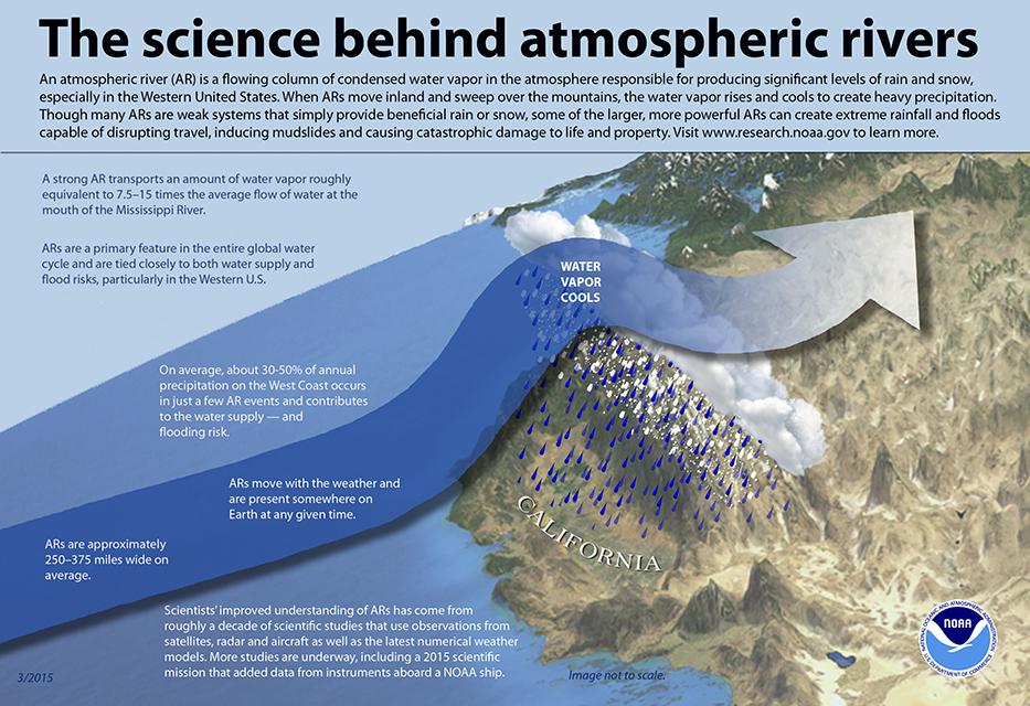
The science behind atmospheric rivers

The science behind atmospheric rivers. Graphic: NOAA

Rivers in the sky

Atmospheric rivers are relatively long, narrow regions in the atmosphere – like rivers in the sky – that transport most of the water vapor outside of the tropics, according to NOAA. When the atmospheric rivers make landfall, they release the water vapor in the form or rain or snow.

“The rivers can stretch from 250 to 370 miles wide and carry a water amount more than 7 times the volume of the Mississippi River,” said Alexi Schnell, water resources specialist with the Water Authority.

The research funds were allocated to the Department of Water Resources to “improve observations, forecasts and decisions in support of atmospheric river precipitation events” as part of the DWR’s Research, Mitigation, and Climate Forecasting Program.

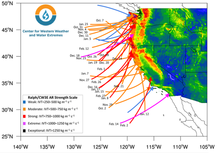
Atmospheric Rivers

Atmospheric Rivers in Water Year 2019. Graphic: Center for Western Weather and Water Extremes

Volatile water resources

A new study led by Scripps Institution of Oceanography at UC San Diego suggests that a new regime of wet and dry extremes is emerging in California. The study shows that the projected increase of extreme precipitation is likely to be caused by streams of moisture in the sky known as atmospheric rivers.

The study was published July 9 in the journal Nature Scientific Reports.

“California already has the most volatile water resources in the country,” according to a news release from Scripps. “Scripps scientists discovered that the state’s precipitation, as it becomes less frequent but preferentially stronger, will vacillate even more wildly between extremes of drought and flooding as a consequence of climate change.”

The federal Bureau of Reclamation, the Southwest Climate Adaptation Science Center, NOAA, the U.S. Geological Survey, and NASA funded the study, “Precipitation regime change in Western North America: The role of Atmospheric Rivers.”

California weather extremes

“As Mediterranean climate regions around the world are becoming more subtropical, the dry season is expanding. California is no exception,” said Alexander Gershunov, a climate scientist at Scripps. “What is exceptional about California is that the heavy precipitation is projected to become more extreme. We knew this from our past work. Now we have identified the mechanism responsible for this bolstering of extremes, and that gives us a more nuanced understanding of what to expect from future hydroclimate and a clearer interpretation of ongoing changes.”
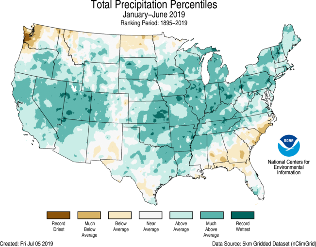
 

Atmospheric Rivers helped California's snowpack in Winter 2018-19.

For the year-to-date 2019, the precipitation total was 19.05 inches, 3.74 inches above average, and the wettest such period in the 125-year record. Graphic: NOAA

Atmospheric Rivers boost snowpack

During the 2018-19 winter, atmospheric river events significantly increased snowpack in the Sierra Nevada and the Rocky Mountains. Both areas are key sources of water supply for the Southwest, including California and San Diego County.

Precipitation in the contiguous U.S. was above average from January to June 2019, according to a NOAA climate report released this week. The report said the 19.05 inches during the six-month period was 3.74 inches above average and the wettest such period in the 125-year record.

The January-to-June 2019 precipitation map showed California’s statewide precipitation was “above average” and “much above average.”

Never Mind Those Earthquakes: Atmospheric Rivers Could Put Sacramento 30 Feet Under Water

The biggest freshwater rivers on Earth don’t flow along the planet’s surface. Instead, they surge and whip through the atmosphere thousands of feet above our heads, carrying 2½ times the amount of water that gushes through the Amazon River at any given time. They’re called atmospheric rivers, or, more aptly, rivers in the sky. These rivers are capable of burying Sacramento under 30 feet of water.

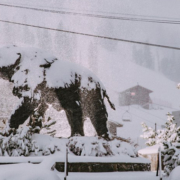
Mammoth Mountain received record snowfall in May 2019. Photo: Mammoth Mountain, Inc. California Reservoirs

California Reservoirs Near Capacity in May

It has been a winter – and spring – for the record books, for California reservoirs and ski resorts. And, it’s not over yet.

Snow has continued to fall throughout May, with several inches or more in the Sierra Nevada and the southern California mountains.

In the lowlands, the City of San Diego has experienced one of its wettest months of May on record. The San Diego National Weather Service reported that Alpine and El Cajon set daily precipitation records on May 23.

The normal rainfall at Lindbergh Field during the water year (October 1 – September 30) averages about 10.3 inches. In the current water year, 12.7 inches of rain has been recorded at Lindbergh Field as of May 23.

May snowfall in the Sierra Nevada

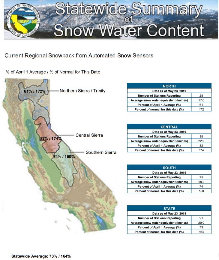
“It’s atypical to see the snowpack increase in May,” said Alexi Schnell, water resources specialist with the San Diego County Water Authority. “The impact of atmospheric river storms helped push snowpack levels in the northern Sierra to 172 percent of normal as of May 23.”

Statewide Summary of Sierra Nevada Snow Water Content

A bountiful year for snow continued into May in the Sierra Nevada. Graphic: California DWR

Record snowfall also allowed many ski areas, from Squaw Alpine to Mammoth Mountain, to extend their ski seasons into late-Spring, with fresh powder in May a bonus for skiers.

A May to remember at Mammoth Mountain

Mammoth Mountain tweeted that it has received 29 inches of snow as of May 23, “officially our snowiest May on record, beating out May 2015.” (Video courtesy of Mammoth Mountain).

Major reservoirs near capacity

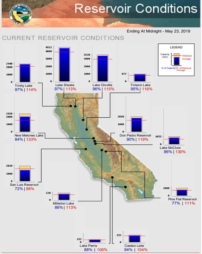
Many of the state’s major reservoirs are near capacity and are significantly above their historical averages as of May 23. Lake Shasta is at 97 percent of capacity and at 113 percent of its historical average.

Most major California reservoirs are near capacity and significantly above historical averages for May 23.

Most major California reservoirs are near capacity and significantly above historical averages for May 23. Graphic: California DWR

Summer is coming

Schnell cautions that this current water year is an exception, and the climatological cycle in California can bring several consecutive years of drought, like the 2015-2017 period, which prompted mandatory water-use reductions.

While the winter and spring has been ‘atypical,’ the summer could set some records too.

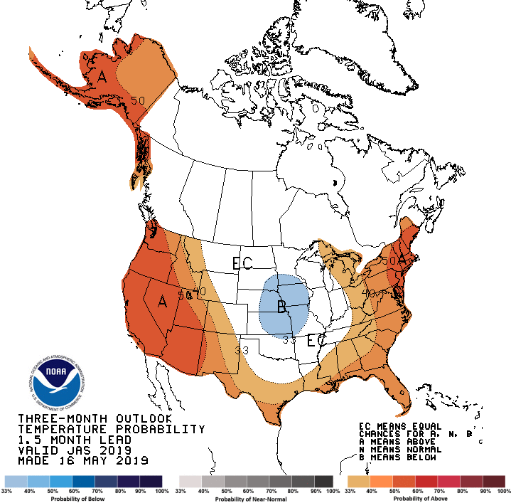
“Looking ahead over the next three months, the National Weather Service forecast shows that there is a greater than 50 percent chance the region will be warmer than normal,” Schnell said.

NWS Climate Prediction Center 3-month temperature outlook

NWS Climate Prediction Center three-month temperature outlook. Graphic: NWS/NOAA

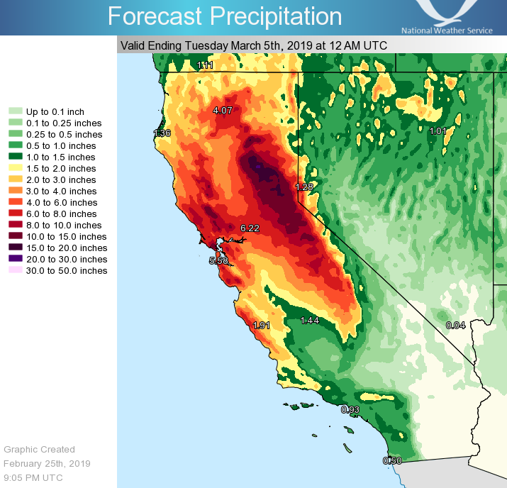
As a result of the atmospheric river weather phenomenon, California has experienced higher than average rainfall in water year 2019. Graphic: National Weather Service

Atmospheric Rivers Benefit State, Regional Water Supply

Atmospheric river events in late January and in February have significantly increased snowpack in the Sierra Nevada and the Rocky Mountains, key sources of water supply for the state and San Diego County.

“We’re thrilled by the amount of precipitation – rain and snow – in San Diego County, the Sierra and the Rockies,” said Dana Friehauf, a resource manager with the San Diego County Water Authority.

The statewide Sierra Nevada snowpack was 151 percent of normal at 104 reporting stations for February 27, according to the California Department of Water Resources. The Rockies have received significant snowfall, which will feed the Colorado River, a source of water supply for the Water Authority. The amount of precipitation in most of the Rocky Mountain region, has ranged from 100 to 150 percent for Water Year 2019 through February 25, according to data from the Natural Resources Conservation Service. The percentage is based on the median between 1981 and 2010.

As a result of the atmospheric river weather phenomenon, California has experienced higher than average rainfall in water year 2019. Graphic: National Weather Service

As a result of the atmospheric river weather phenomenon, California has experienced higher than average rainfall in water year 2019. Graphic: National Weather Service

Record rainfall recorded in San Diego

Locally, a bountiful February has helped make Water Year 2019 one of the wettest on record at Lindbergh Field. Preliminary data from the National Weather Service indicates 10.62 inches of precipitation at the San Diego International Airport, with 3.42 inches coming so far in February 2019.

The Weather Service report issued Feb. 24 also shows that last year at this time, just 1.91 inches of precipitation had been recorded at the airport (for Water Year 2018).

In fact, Water Year 2018 (October 1 – September 30) was the second-driest on record since 1850 at Lindbergh Field, with just 3.3 inches of rain, or 32 percent of the long-term average.

Friehauf reminds San Diegans that even in years such as this, when rainfall is plentiful, that water-use efficiency remains a way of life. For instance, each rainstorm is an opportunity to turn off irrigation systems for days or even weeks at a time. She also suggests residents use rain barrels to collect or “harvest” water that can be used later, when the weather is drier.

Capturing the water from gutters and downspouts also reduces the amount of water flowing into storm drains. Homeowners can get rebates on residential rain barrels. Find details on rain barrel rebates here.