Posts

Precipitation-Snowpack Survey-Sierra Nevada-DWR

Precipitation Below Average in California

Precipitation is below average in California for the current water year. Despite recent storms that increased the statewide Sierra Nevada snowpack to 70% of average to date, the state is experiencing its second consecutive below average year for rain and snow. The water year starts on October 1 and ends September 30.

The Department of Water Resources Feb. 3 conducted the second manual snow survey of the season at Phillips Station. The manual survey recorded 63 inches of snow depth and a snow water equivalent, or SWE, of 17 inches, which is 93% of average for that location, according to the DWR. The SWE measures the amount of water contained in the snowpack and is a key component of DWR’s water supply forecast.

“The recent blast of winter weather was a welcome sight, but it was not enough to offset this winter’s dry start,” said DWR Director Karla Nemeth. “While there is still a chance we will see additional storms in the coming weeks, the Department and other state agencies are preparing for the potential for a second consecutive year of dry conditions.”

 La Niña-Sierra Nevada-snowpack-climate-snow survey

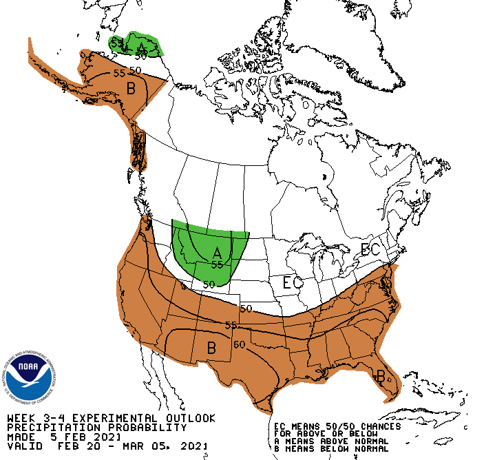
Below normal precipitation is favored throughout most of the southern tier of the United States in late February to early March, according to the National Weather Service Climate Prediction Center. La Niña conditions remain over the Pacific Ocean.

Precipitation below normal

Statewide snow survey measurements reflect those dry conditions. Measurements from DWR’s electronic snow survey stations indicate that statewide the snowpack’s SWE is 12.5 inches, or 70% of the February 3 average, and 45% of the April 1 average. April 1 is typically when California’s snowpack is the deepest and has the highest SWE.

“The recent atmospheric storms have brought rain and snow to the northern Sierra Nevada, but conditions are still well below normal,” said Goldy Herbon, San Diego County Water Authority senior resources specialist.

Following last year’s below average water year, northern California is now experiencing its second straight water year of below average precipitation.

Colorado River Basin

Another source of the state’s water supply, the Colorado River Basin, isn’t faring much better. The water year 2021 precipitation at the end of January for the Colorado River Basin is 66% of normal, according to the U.S. Bureau of Reclamation.

Precipitation totals to date are behind historical averages for two of the main sources of San Diego County’s supply, with two months to go in the winter season but, a couple of atmospheric rivers can change that quickly.

“The San Diego region will have a plentiful and reliable source of water due to actions taken by the Water Authority and its 24 member agencies to diversify the water supply,” said Herbon. “Continuing efforts to expand supply sources, including desalination, water reuse, and recycling, will ensure that the water needs are met for the region’s 3.3 million people and its $245 billion economy.”

Fall 2020 was extremely dry, especially in the Sierra Nevada, and follows last year’s below-average snow and precipitation, according to the DWR. With only a couple months remaining in California’s traditional wet season, DWR officials say Californians should look at ways to reduce water use at home.

snowpack-reservoirs-Snow survey

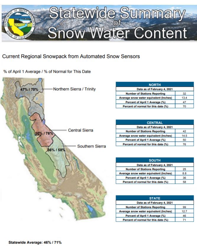
Statewide Sierra Nevada snowpack is 71% of average for February 4, 2021. Graphic: California Department of Water Resources

A Surge From an Atmospheric River Drove California’s Latest Climate Extremes

Flooding rains and record snow in California last week marked another extreme swing of the state’s climate pendulum. The widespread downpours triggered mudslides that damaged homes and roads near some of the huge fire scars from last summer, and also brought some of the water the state will need to end a months-long hot and dry streak and douse a record-setting wildfire season that extended into January.

February 1: Is California Still Heading for a Multi-Year Drought?

This updates a post from December on the likelihood of California entering a second dry year. Normally, a second dry year brings drought operations for California’s overall water system operations.

Today, it is even likelier that California is entering a multi-year drought.

Precipitation conditions have improved somewhat with a nice atmospheric river this last week, but remain 51% of average for this time of year for the Sacramento Valley. (San Joaquin and Tulare basins are 61% and 47% of historical seasonal average precipitation so far.) Snowpack has improved somewhat with very recent storms, but is about as scarce as the precipitation.

California Storm Winds Down After Deluge of Rain and Snow

A drenching storm that brought California much-needed rain in what had been a dry winter wound down Friday after washing out Highway 1 near Big Sur, burying the Sierra Nevada in snow and causing muddy flows from slopes burned bare by wildfires.

The atmospheric river weather system that barreled ashore in Northern California early in the week rolled quickly through Southern California overnight and was moving east before dawn. Remnants unleashed occasional downpours and hail.

Storm System To Drop Heavy Rain, Snow In San Diego County

The third winter storm of the week has arrived in San Diego County, bringing heavy rain to the region Friday along with the possibility of snow in the mountains, according to the National Weather Service.

The “atmospheric river” is making its way east across the county, with the heaviest rainfall expected early Friday morning, then scattered showers into Friday afternoon, forecasters said.

Greater San Diego Could Get 1.5 inches of Rain from Atmospheric River

Greater San Diego could get 1.5 inches of rain from an “atmospheric river” weather system that will flow ashore Thursday night and last through Friday, when it also will leave a few inches of snow on the county’s highest mountain peaks, says the National Weather Service.

What is an Atmospheric River? California has Long History of Intense Rain Storms, Floods

An intense cold front will tap into subtropical moisture and take on atmospheric river characteristics as it moves southeastward through the Central Coast on Wednesday into Thursday.

At this time, between 2 and 4 inches of rain is expected along the Central Coast. However, if the front stalls over a particular area, rainfall amounts will be much higher.

As Storm Sets Up to Pummel Tahoe, Meteorologists Forecast a Future Without Snow

One week, it’s fires; the next, it’s feet upon feet of snow. In the middle of January, high winds and dry conditions sparked wildfires throughout California. Now, an atmospheric river is taking aim at the state with a huge amount of water. In the Sierra Nevada and Lake Tahoe region, forecasters are calling for between three and six feet of snow by the end of this week.

Biggest Storm of the Year is About to Hit Northern California. When to Expect the Worst of It

Clear out the gutters. Plan some extra time for the morning commute Wednesday. And don’t even think about heading up the hill for a few days. The biggest storm of the season is barreling down on Northern California. The Sacramento region could see up to 3 inches of rain this week – perhaps doubling the amount of rain we’ve received for the entire winter season – as an extreme storm arrives Tuesday afternoon. The cold, wet system will bring dangerous winds to the region, localized flooding and up to 80 inches of snow – yes, that’s nearly 7 feet – to the summits on Interstate 80 and Highway 50.

San Diego Scientists Track the Region’s Biggest Rainmakers

San Diego researchers are getting a better understanding of the storm systems that bring the region most of its rain and they are getting that information the old fashion way — from weather balloons. Last March, gray rain-filled skies seemed to dip into the ocean as a storm moved across the region.