Posts

New Research Finds Climate Models Mostly Get It Right

New climate research, which was done mostly in San Diego, finds that a study of land temperatures during the last ice age confirms some widely held thoughts about climate change.

Lead author Alan Seltzer, a paleoclimatologist at the Wood’s Hole Oceanographic Institute, studied ancient water as a way to gain insight into previously unrecorded planetary temperatures.

San Diego County's Climate Future-Atmospheric Rivers-Water Supply

San Diego County’s Climate Future

Climate change and drought will impact San Diego County’s climate future, but regional water supply planning and adaptation measures will ensure a safe, reliable supply for the region.

Water supply strategy was one of the key points participants learned about during a Monday panel discussion, “San Diego County’s Climate Future,” hosted online by the San Diego County Water Authority, Citizens Water Academy, Leaders 20/20 and San Diego Green Drinks.

Panel moderator Kelley Gage, Water Authority Director of Water Resources, kicked off the climate conversation by describing the investments and steps taken by the Water Authority and its 24 member agencies to secure the region’s water future.

Water supply and San Diego County’s climate future

“Since our founding more than 75 years ago, our mission in partnership with our 24 member agencies is to ensure a clean and reliable supply of water for the region,” said Gage. “As part of that mission we’re involved in partnerships like the one that we have today and the research to ensure that we have planned for the impact of climate change in our water supplies.”

Gage said the Water Authority has developed a climate action plan.

“As part of our strategic planning we have developed a climate action plan which is an interdisciplinary effort to promote and coordinate implementation of climate change strategies and related activities across the Water Authority,” said Gage. “We have reached our goals for 2020 and we are on track for our 2030 goals.”

Atmospheric rivers and water management

The Water Authority partnered with the Scripps Institution of Oceanography, Center for Wester Weather and Water Extremes, at UC San Diego in 2020 to better predict atmospheric rivers and improve water management before, during, and after those seasonal storms. The Center and its partners share best practices in forecast-informed reservoir operations, increased research around atmospheric rivers and droughts, and develop strategies for mitigating flood risk and increasing water supply reliability.

Forecast Informed Reservoir Operations

Stored water releases

Marty Ralph, Researcher in Climate, Atmospheric Science & Physical Oceanography at Scripps Institution of Oceanography, and Director of the Center for Western Weather and Water Extremes, opened the panel with information on advanced research around atmospheric rivers.

Atmospheric rivers are long narrow bands of airborne water vapor, providing up to half the annual precipitation and mountain snow that is key to California’s water supply. New research allows reservoir operators to use atmospheric river forecasts to better predict storm events and prevent unnecessary stored water releases.

“This stored water has helped to cope with the third driest year on record for the region,” said Ralph.

Atmospheric Rivers

Atmospheric rivers more “impactful” with climate change

Another Scripps Institution of Oceanography researcher, Alexander “Sasha” Gershunov, said that California receives most the country’s extreme precipitation events due to atmospheric rivers. Low and medium intensity precipitation events are predicted to decrease, while high intensity precipitation events are predicted to increase, especially in California.

“With warming, atmospheric rivers get stronger, wetter, longer, and more impactful, and they also produce more of our annual precipitation total,” said Gershunov. “There are many implications of these changes from water resources management, to wildfires, to debris flows.”

Sasha Extreme Weather Events

San Diego Regional Climate Collaborative

Darbi Berry, Program Manager at the San Diego Regional Climate Collaborative, described projects moving forward in the region to address equity issues related to water availability and pollution. Advancing the Nexus of Water and Equity looks at how different communities are impacted by a changing climate.

Increased variability in rainfall events and the potential for flooding in the San Diego region is a contributing factor to ongoing water quality issues in disadvantaged neighborhoods. One project carried out to address these equity issues is the National City, Paradise Creek project which re-graded a creek that was continuously overflowing and causing flood damage during atmospheric river events.

Nexus of Water and Equity

Watch the San Diego County’s Climate Future presentations by Marty Ralph, Sasha Gershunov, and by Darbi Berry here: bit.ly/3aBVt1Z

CW3E

High Performance Computing Makes a Splash in Water Cycle Science

The San Diego Supercomputer Center and the Scripps Institution of Oceanography, both located at UC San Diego, have forded a stream between high-performance computing and water cycle science.

This summer, SDSC’s petascale Comet supercomputer—which can perform nearly 3 quadrillion operations per second—will conclude formal service as a National Science Foundation resource and transition to exclusive use by Scripps’ Center for Western Weather and Water Extremes. The transition enables CW3E researchers to leverage Comet’s computing capabilities to improve weather and hydrological forecasts with the goal of enhancing the decision-making process associated with reservoir management over California, which could result in increased water supply and reduced flood risk over the region.

Water Authority Applauds Governor’s Targeted Approach to Drought

Board Chair responds to Gov. Newsom’s executive action today

April 21, 2021 – “We applaud Governor Newsom for taking a targeted, flexible, and iterative
approach to drought management that provides support for individual regions that are suffering
from drought while also recognizing regions like San Diego County that have sufficient water
supplies due to three decades of investments in supply reliability. The governor’s Water Portfolio
Strategy aligns with our long-term investments in a diversified water portfolio, desalinated
seawater, conserved water from Imperial County, local water-use efficiency measures, and
increased water storage. Because of those actions and others, our residents have enough water for
2021 and future dry years. We also applaud the efforts of our ratepayers, who have cut per capita
water use by nearly half since 1990.

“In addition, the innovative and resilient supply portfolio created by the Water Authority and its
24 member agencies puts our region in a unique position to provide solutions that can help
California weather this drought and future droughts – for instance, by storing water in Lake
Mead. We look forward to working with the governor and his staff to collaborate on projects and
programs where we can use our assets and experience to help areas that are hit hard by drought
in the face of a changing climate.

“Finally, we are proud to be a founding member of the coalition of water agencies mentioned by
the governor that support the important scientific research being done on climate change by our
own Scripps Institution of Oceanography.”

— Gary Croucher, Board Chair, San Diego County Water Authority

Water Year 2021 Characterized by Persistent Dry Weather and Worsening Drought in California

• Total precipitation has been well below normal throughout much of California during water year (WY) 2021
• In some regions, drier than normal conditions extend back to the start of WY 2020
• Drought has expanded and intensified across the state, and current water storage levels are below normal in many
reservoirs
• Below-normal snowpack in the Sierra Nevada may limit water resource availability as summer approaches
• The abnormally dry conditions were driven by a lack of landfalling atmospheric rivers (ARs) and persistent
ridging/blocking over the Northeast Pacific Ocean
• Drought is expected to continue through spring 2021, thereby increasing the threat of significant wildfire activity in
summer 2021

Opinion: SB 1 Provides Critical Protection for California’s Beloved Coastline

I didn’t see the ocean until I was 18 years old. That late start didn’t stop me from falling in love with the sea, a love I have pursued in earnest ever since I moved to San Diego.

Here in our community, and in communities throughout California, warming waters and rising sea levels threaten both the coast we love and the people and businesses that are located there. Predictions are, that left unchecked, sea level rise will cause billions of dollars in damage in California and disrupt countless lives.

Phillips Station-Mountain Snowpack-Climate Change-DWR Snow Survey

New Study Identifies Mountain Snowpack Most “At-Risk” from Climate Change

As the planet warms, scientists expect that mountain snowpack should melt progressively earlier in the year. However, observations in the U.S. show that as temperatures have risen, snowpack melt is relatively unaffected in some regions while others can experience snowpack melt a month earlier in the year.

This discrepancy in the timing of snowpack disappearance—the date in the spring when all the winter snow has melted—is the focus of new research by scientists at Scripps Institution of Oceanography at the University of California San Diego.

In a new study published March 1 in the journal Nature Climate ChangeScripps Oceanography climate scientists Amato Evan and Ian Eisenman identify regional variations in snowpack melt as temperatures increase, and they present a theory that explains which mountain snowpacks worldwide are most “at-risk” from climate change. The study was funded by NOAA’s Climate Program Office.

Mountain snowpack changing rapidly in coastal regions

Looking at nearly four decades of observations in the Western U.S., the researchers found that as temperatures rise, the timing of snowpack disappearance is changing most rapidly in coastal regions and the south, with smaller changes in the northern interior of the country. This means that snowpack in the Sierra Nevada, the Cascades, and the mountains of southern Arizona is much more vulnerable to rising temperatures than snowpack found in places like the Rockies or the mountains of Utah.

The scientists used these historical observations to create a new model for understanding why the timing of snowpack disappearance differs widely across mountain regions. They theorize that changes in the amount of time that snow can accumulate and the amount of time the surface is covered with snow during the year are the critical reasons why some regions are more vulnerable to snowpack melt than others.

Mountain Snowpack-Climate Change-Scripps Institution of Oceanography

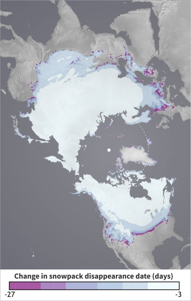
Using a new model, the Scripps researchers theorize that snowpack in coastal regions, the Arctic, and the Western U.S. may be among the most at-risk for premature melt from rising temperatures. Graphic: Courtesy Scripps Institution of Oceanography

Snowpack vulnerable due to increasing temperature

“Global warming isn’t affecting everywhere the same. As you get closer to the ocean or further south in the U.S., the snowpack is more vulnerable, or more at-risk, due to increasing temperature, whereas in the interior of the continent, the snowpack seems much more impervious, or resilient to rising temperatures,” said Evan, lead author of the study. “Our theory tells us why that’s happening, and it’s basically showing that spring is coming a lot earlier in the year if you’re in Oregon, California, Washington, and down south, but not if you’re in Colorado or Utah.”

Applying this theory globally, the researchers found that increasing temperatures would affect the timing of snowpack melt most prominently in the Arctic, the Alps of Europe, and the southern region of South America, with much smaller changes in the northern interiors of Europe and Asia, including the central region of Russia.

Climate Change and snowmelt

To devise the model that led to these findings, Evan and Eisenman analyzed daily snowpack measurements from nearly 400 sites across the Western U.S managed by the Natural Resources Conservation Service Snowpack Telemetry (SNOTEL) network. They looked at SNOTEL data each year from 1982 to 2018 and focused on changes in the date of snowpack disappearance in the spring. They also examined data from the North American Regional Reanalysis (NARR) showing the daily mean surface air temperature and precipitation over the same years for each of these stations.

Using an approach based on physics and mathematics, the model simulates the timing of snowpack accumulation and snowpack melting as a function of temperature. The scientists could then use the model to solve for the key factor that was causing the differences in snowpack warming: time. Specifically, they looked at the amount of time snow can accumulate and the amount of time the surface is covered with snow.

“I was excited by the simplicity of the explanation that we ultimately arrived at,” said Eisenman. “Our theoretical model provides a mechanism to explain why the observed snowmelt dates change so much more at some locations than at others, and it also predicts how snowmelt dates will change in the future under further warming.”

A “shrinking winter” and longer fire season

The model shows that regions with very large swings in temperature between the winter and summer are less susceptible to warming than those where the change in temperature from winter to summer is smaller. The model also shows that regions where the annual mean temperature is closest to 0˚C are less susceptible to early melt. The most susceptible regions are ones where the differences between wintertime and summertime temperatures are small, and where the average temperature is either far above, or even far below 0˚C.

For example, in an interior mountain region of the U.S. like the Colorado Rockies, where the temperature dips below 0°C for about half the year, an increase of 1°C can lead to a quicker melt by a couple of days—not a huge difference.

However, in a coastal region like the Pacific Northwest, the influence of the ocean and thermal regulation helps keep the winter temperatures a bit warmer, meaning there are fewer days below 0°C in which snow can accumulate. The researchers hypothesize that in the region’s Cascade Mountains, a 1°C increase in temperature could result in the snow melting about a month earlier in the season—a dramatic difference.

Arctic “at risk”

One of the most “at-risk” regions is the Arctic, where snow accumulates for nine months each year and takes about three months to melt. The model suggests that 1°C warming there would result in a faster melt by about a week—a significant period of time for one of the fastest warming places on Earth.

This study builds upon previous work done by Scripps scientists since the mid-1990s to map out changes in snowmelt timing and snowpacks across the Western U.S. The authors said that a “shrinking” winter—one that is shorter, warmer, and with less overall precipitation—has adverse societal effects because it contributes to a longer fire season. This could have devastating impacts on already fire-prone regions. In California, faster snowpack melt rates have already made forest management more difficult and provided prime conditions for invasive species like the bark beetle to thrive.

Funding for this work was provided by a NOAA/CPO grant to the University of California.

Landfalling Atmospheric Rivers Increase in First Quarter of Water Year 2021 Over 2020

A Scripps Center for Western Weather and Water Extremes report shows that more atmospheric rivers have made landfall over the U.S. West Coast in the first four months of Water Year 2021 compared to the previous period in 2020.

Atmospheric Rivers-CW3E-Scripps-Rain

Landfalling Atmospheric Rivers Increase in First Quarter of Water Year 2021 Over 2020

A Scripps Center for Western Weather and Water Extremes report shows that more atmospheric rivers have made landfall over the U.S. West Coast in the first four months of Water Year 2021 compared to the previous period in 2020.

The four months of Water Year 2021 experienced a total of 35 landfalling ARs over the U.S. West Coast, six more than the first four months of Water Year 2020, according to the CW3E quarter year summary released February 11.

Key takeaways from the CW3E update on atmospheric rivers

• The first four months of Water Year 2021 experienced a total of 35 landfalling ARs over the U.S. West Coast, 6 more than the first four months of Water Year 2020.
• Water Year 2021 also experienced more than twice as many strong or greater ARs (14) compared to Water Year 2020 (6).
• While Water Year 2021 saw more ARs in its first 4 months compared to Water Year 2020, a large majority of those ARs were
strongest over the Pacific Northwest (Oregon and Washington).
• The average landfall latitude thus far in Water Year 2021 was 45.9°N compared to 43.9°N during the first half of Water Year 2020.
• The lack of landfalling ARs over Southern California and Baja California has resulted in much drier conditions over the southwestern U.S. compared to WY 2020.

CW3E-Atmospheric Rivers-Water Year 2021

The four months of Water Year 2021 experienced a total of 35 landfalling ARs over the U.S. West Coast, six more than the first four months of Water Year 2020. Graphic: Center for Western Weather and Water Extremes

Distribution of Landfalling Atmospheric Rivers over the U.S. West Coast During Water Year 2021: Quarter Year Summary

Atmospheric River-NOAA-WNN-CW3E

A partnership with the San Diego County Water Authority and the Scripps Institution of Oceanography at UC San Diego seeks to optimize water management to better predict atmospheric rivers before, during, and after those seasonal storms.

In August 2020, Scripps Center for Western Weather and Water Extremes (CW3E) launched the Water Affiliates Group, which brings together cutting-edge science and hands-on water industry experience to enhance reservoir operations in light of the changing climate. The Water Authority has a long-running alliance with Scripps and is among six founding water agencies statewide.

CW3E and its partners will share and support best practices in forecast-informed reservoir operations, increase research around atmospheric rivers and droughts, and develop strategies for mitigating flood risk and increasing water supply reliability.

Atmospheric Rivers-CW3E-water supply

The above image, from the EOS article, is a depiction of an atmospheric river, interacting with West Coast mountains and a midlatitude cyclone over the northeast Pacific on 5 February 2015. This image provides an example of approximate locations of associated tropical moisture exports and a warm conveyor belt (WCB). Graphic: Adapted from NOAA/ESRL Physical Sciences Division via CW3E

Scripps Oceanography Gets Share of California Energy Commission Contract to Simulate Climate Change

The California Energy Commission has awarded a $1.5 million contract to three University of California campuses, including UC San Diego, that will work in tandem to better simulate climate change scenarios that can be used by utilities and others to anticipate the effects.