Tag Archive for: Colorado River Basin

More Rain Drenching San Diego County But Local Reservoirs Still Parched

The San Diego region is being drenched by a rare spring storm system, but all that moisture isn’t adding much to the region’s supply of drinking water.

The snow was falling in the San Diego county mountains on Wednesday, pretty heavily in some places.

That comes courtesy of a slow-moving cold storm system coming into the region from the north.

The region’s National Weather Service office called this prolonged six-week run of rain in March and April, pretty rare for the region.

Anza-Borrego Desert Research Center-Sicco Rood-March-2020-WNN water supply

Water Supply Diversification Overcomes Dry Winter

No ‘March Miracle’ for snow and rain in California, but the San Diego County Water Authority has diversified water supply sources to weather the boom-and-bust cycle of California winters.

March brought abundant precipitation throughout California, but not enough to offset a dry February. Most large urban water agencies in the state maintain a reliable water supply in wet and dry years.

“California’s climate variability is why a water resilience portfolio is needed to provide a safe and plentiful water supply,” said Goldy Herbon, Water Authority senior water resources specialist. “Whether a wet or dry year, the Water Authority and its 24 member agencies have successfully diversified water sources to ensure a reliable supply to meet the needs of the region’s 3.3 million people.”

The supply sources include water from the Claude “Bud” Lewis Carlsbad Desalination Plant, where ten workers volunteered to live on-site to keep the water flowing during the coronavirus pandemic.

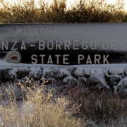
Lindbergh Field has received 9.76 inches of rain – or 108% of normal – from October 1, 2019 – April 2, 2020. Many areas in the San Diego region received snow in March, including the Anza-Borrego Desert State Park.

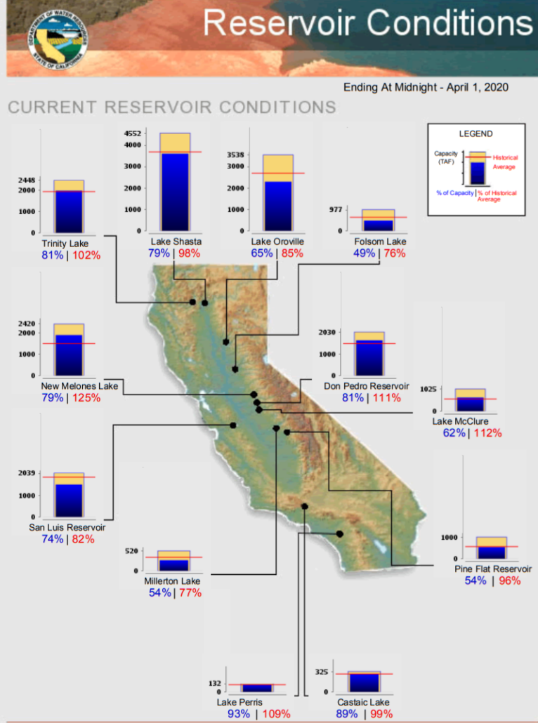
Even with a lackluster winter, the state’s six largest reservoirs hold between 82% and 125% of their historical averages for April 1, according to the California Department of Water Resources. Lake Shasta is 98% of its historical average and is at 79% of capacity.

Major California Reservoirs-April 1 2020-WNN-CA DWR graphic

The Department of Water Resources April 1 conducted the fourth manual snow survey of 2020 at Phillips Station near Lake Tahoe. The manual survey recorded 43.5 inches of snow depth and a snow water equivalent (SWE) of 16.5 inches, which is 66% of the April average for this location.

The SWE measures the amount of water contained in the snowpack, which provides a more accurate forecast of spring runoff. Measurements from the 130 electronic snow sensors, scattered throughout the state, indicate that the statewide snowpack’s water equivalent is 15.2 inches, or 53% of the April average.

Sierra Nevada Snowpack Comparison-NASA satellite image-WNN-April 2020

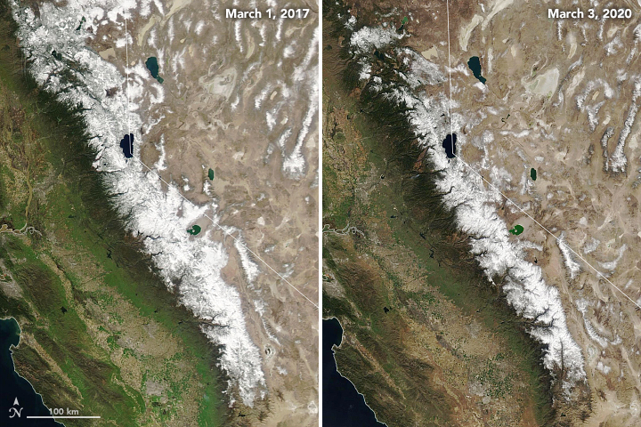
The natural-color satellite images above, acquired by the Moderate Resolution Imaging Spectroradiometer (MODIS) instruments on NASA’s Terra and Aqua satellites, show the area covered by snow in March 2020 compared to March 2017 (a record high year). Graphic: NASA/NASA JPL

“While today’s survey results show our snowpack is better off than it was just last month, they still underscore the need for widespread, wise use of our water supplies,” said DWR Director Karla Nemeth. “California’s climate continues to show extreme unpredictability, and February’s record dryness is a clear example of the extremes associated with climate change.”

On average, the snowpack supplies about 30% of California’s water needs as it melts in the spring and early summer, the state agency reported in news release.

Largest US Dam Removal Stirs Debate Over Coveted West Water

KLAMATH, Calif.  — California’s second-largest river has sustained Native American tribes with plentiful salmon for millennia, provided upstream farmers with irrigation water for generations and served as a haven for retirees who built dream homes along its banks.

With so many demands, the Klamath River has come to symbolize a larger struggle over the American West’s increasingly precious water resources, and who has claim to them.

Now, plans to demolish four hydroelectric dams on the Klamath’s lower reaches — the largest such demolition project in U.S. history — have placed those competing interests in stark relief. Tribes, farmers, homeowners and conservationists all have a stake in the dams’ fate.

Tensions Emerge as a Top Arizona Official Discusses Tribes’ Unresolved Water Claims

Many of Arizona’s Native tribes have long-standing claims to water rights that haven’t yet been settled, and a discussion of efforts to negotiate possible agreements took center stage at a meeting of Gov. Doug Ducey’s water council.

The meeting grew tense after Arizona’s top water official gave a presentation on the status of tribes’ unresolved water claims, and then didn’t allow leaders of four tribes to speak.

Arizona Department of Water Resources Director Tom Buschatzke said he sent letters a week ago to all 22 federally recognized tribes in Arizona inviting them to speak about the issue at upcoming meetings later this year.

‘This System Cannot Be Sustained’

The Colorado River Basin is the setting for some of the most drawn-out and complex water issues in the Western U.S. In 2019, the Colorado River Drought Contingency Plan — a water-conservation agreement between states, tribal nations and the federal government for the basin, now in its 20th year of drought — passed Congress. This year, it goes into effect.

2020 will also see the start of the renegotiation of the Colorado River Interim Guidelines. The guidelines, which regulate the flow of water to users, were created in 2007 without tribal consultation and are set to expire in 2026. The 29 tribal nations in the upper and lower basins hold some of the river’s most senior water rights and control around 20% of its annual flow.

West’s Biggest Reservoir Is Back on the Rise, Thanks to Conservation, Snow

LAS VEGAS—The largest reservoir in the Western U.S., Lake Mead, is rising again after more than a decade of decline, and at least some credit goes to the local National Hockey League team.

“Reality check!” Ryan Reaves, right wing for the Vegas Golden Knights, yells as he body-slams a man through a plate-glass window for excessive lawn watering in a television commercial. “Vegas is enforcing water waste big time.”

Ads like this began airing last year as part of a campaign by the Southern Nevada Water Authority to persuade the more than two million residents of this sprawling desert metropolis to use less water. Using a carrot-and-stick approach, including paying landowners to remove grass and fining for overuse, the agency said it has cut total Colorado River water consumption by 25% over the past two decades, even as the population it serves has grown around 50%.

Lawmakers Angle for a Seat at the Table in Colorado River Drought Negotiations

CHEYENNE – For nearly a century, the Colorado River Compact has practically been seen as scripture for states from Wyoming all the way down to the Mexican border.

The compact – written in the years populations in the American Southwest first began to explode – has been the code by which life along the Colorado River Basin has been granted, a strict allocation of the snowmelt from the highest peaks of the Rocky Mountains to the Arizona desert and the parched reaches of the expansive fields of Southern California.

How Beef Eaters in Cities are Draining Rivers in the American West

It’s not exactly news that the rivers of the western U.S. are in trouble.

For decades, their water has been siphoned off by climate change-fueled heat and an ever-growing human demand for grassy front lawns and long showers. The biggest user of river water by far, though, is agriculture—and new research shows that across the western United States, a third of all consumed water goes to irrigate crops not for human consumption, but that are used to feed beef and dairy cattle. In the Colorado River basin, it’s over 50 percent.

The burgers, steaks, yogurt, and ice cream Americans eat in abundance, the new results show, is directly related to the overuse of river water—leaving the ecosystems and communities that depend on those rivers drastically stressed under even the best of circumstances.

Climate Change Has Stolen More Than a Billion Tons of Water From the West’s Most Vital River

The Colorado River’s average annual flow has declined by nearly 20 percent compared to the last century, and now a new study has identified one of the main culprits: Climate change is causing mountain snowpack to disappear, leading to increased evaporation.

Four recent studies have found that up to half of the drop in the Colorado’s average annual flow since 2000 has been driven by warmer temperatures. Now, two U.S. Geological Survey researchers have concluded that much of this climate-induced decline — amounting to 1.5 billion tons of missing water, equal to the annual water consumption of 10 million Americans — comes from the fact that the region’s snowpack is shrinking and melting earlier. Having less snow to reflect heat from the sun, known as the albedo effect, creates a feedback loop, they say.

Imperial Valley Conservation Efforts Benefit San Diego, Southwest

The San Diego County Water Authority’s Board of Directors visited the Imperial Valley January 30 for a day-long tour that highlighted areas critical to the agency’s Regional Conveyance System Study. Board members approved a study in July 2019, to evaluate a new regional water conveyance system that would deliver water from the Colorado River to San Diego County and provide multiple benefits across the Southwest. The Board will hear results from the first phase of the study this spring before deciding whether to move ahead with Phase B. The tour started in southwestern Imperial County, where the All-American Canal meets the Westside Main Canal, an historic location where, starting in 1919, water from a canal system in Mexico first flowed into the western half of the Imperial Valley.