Colorado River Drought Behind Rural-Urban Tensions in the Centennial State
Western Colorado rancher Bill Fales said he thinks that California will come for Colorado’s water someday soon.

Western Colorado rancher Bill Fales said he thinks that California will come for Colorado’s water someday soon.

Santee homeowners Edie and Tate Thomas created a beautiful landscape with California native plants to save water, beautify their home, and support the region’s wildlife. Their effort won the 2023 Padre Dam Municipal Water District landscape makeover contest.
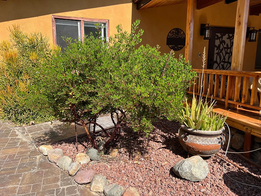
Buried large unglazed clay pots in their yard called ollas, allows watering the plants with minimal water loss. Photo: Padre Dam Municipal Water District
In 2018, the couple began working on their makeover project. Edie Thomas is an architect, and Tate Thomas is a contractor. They took advantage of their building and design skills by creating a topography to capture and preserve the rainwater falling on their yard.
Their landscape is irrigated through underground rock ravines that collect rainwater in a rock-lined underground cistern reservoir which flows water to plants through gravity. They also buried large unglazed clay pots in their yard called ollas, which have above-ground access points to refill them with water. Plants wrap their roots around the porous ollas, which seep water out as needed, watering the plants with minimal water loss.
Edit Thomas advises other homeowners to do the same with their landscape topography.
“I always recommend people visualize a single drop of rainwater falling at the highest point of your landscape,” she said. “Watch where gravity takes that raindrop and plan your landscape around that flow.”
The pair also use drip irrigation about once a month along with occasional hand watering during extended dry periods.
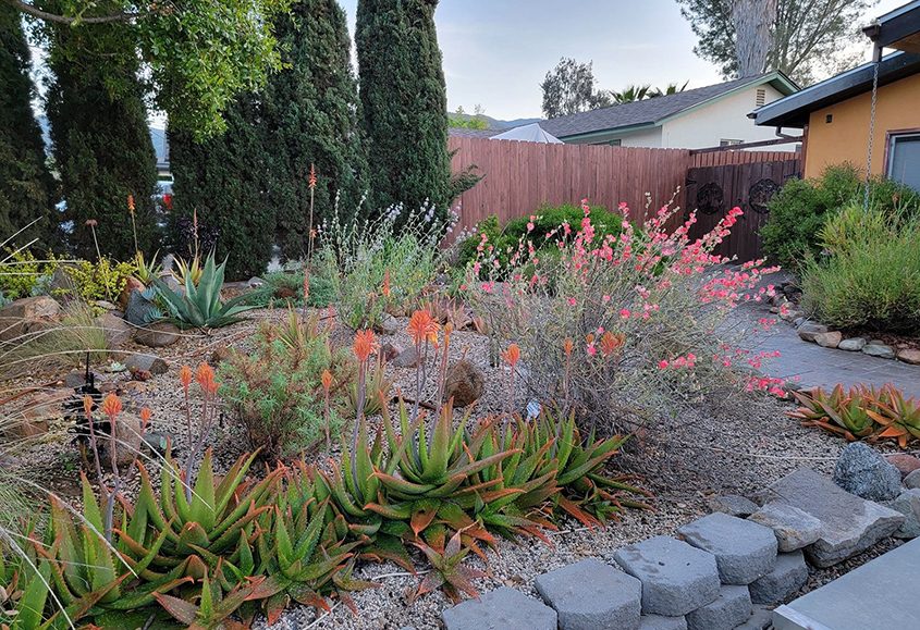
A wide variety of California native plants are featured in the winning landscape design. Photo: Padre Dam Municipal Water District
Long nature walks and information from the California Native Plant Society inspired the Thomas’s to use native plants for most of their landscape, mixing colors and texture to be visually appealing. They have been richly rewarded with an ecosystem of butterflies, caterpillars, bees, birds, and bunnies. They describe their design concept as “playful chaos.”
The sidewalk in front of the garden is designed to be a community space for those walking by. The large California Coastal Live Oak provides shade to the retaining wall, designed as a place to sit and rest. Visitors can browse through books from the couple’s Little Free Library. Water-efficient herbs growing in the planter boxes under the tree are offered to those who pass by.
Edie and Tate Thomas spend most evenings on their patio, enjoying the space and watching their ecosystem thrive. They look forward to watching the plants grow and mature in the coming years and even decades.
“It’s so rewarding to see people come by and rest in the shade or take some rosemary for their dinner,” said Edie Thomas. “I love that we get to give a small square of land back to nature and that our neighbors enjoy it as much as we do.”
(Editor’s note: The Padre Dam Municipal Water District is one of the San Diego County Water Authority’s 24 member agencies that deliver water across the San Diego County region.)
A new study from UC San Diego Scripps Institution of Oceanography researcher emeritus Peter Bromirski uses nearly a century of data to show that the average heights of winter waves along the California coast have increased as climate change has heated up the planet.
A new study from UC San Diego Scripps Institution of Oceanography researcher emeritus Peter Bromirski uses nearly a century of data to show that the average heights of winter waves along the California coast have increased as climate change has heated up the planet.
The study, published August 1 in the Journal of Geophysical Research – Oceans, achieved its extraordinarily long time series by using seismic records dating back to 1931 to infer wave height, a unique but accepted method first developed by Bromirski in 1999. The results, made more robust by their 90 years of statistical power, join a growing body of research that suggests storm activity in the North Pacific Ocean has increased under climate change.
If global warming accelerates, growing winter wave heights could have significant implications for flooding and erosion along California’s coast, which is already threatened by accelerating sea-level rise.
When waves reach shallow coastal waters, some of their energy is reflected back out to sea, Bromirski said. When this reflected wave energy collides with waves approaching the shoreline, their interaction creates a downward pressure signal that is converted into seismic energy at the seafloor. This seismic energy travels inland in the form of seismic waves that can be detected by seismographs. The strength of this seismic signal is directly related to wave height, which allowed him to calculate one from the other.
In using this relationship to infer wave height, Bromirski had to filter out the “noise” of actual earthquakes, which he said is easier than it sounds because earthquakes are typically much shorter in duration than the ocean waves caused by storms.
Bromirski developed this novel way to calculate wave heights out of necessity. Seeing patterns or trends in phenomena such as storm activity or big wave events associated with climate change requires many decades of data, and the buoys that directly measure wave heights along the California coast have only been collecting data since around 1980. Of particular interest to Bromirski were the decades prior to 1970 when global warming began a significant acceleration. If he could get his hands on wave records stretching back several decades before 1970, then he could assess the potential influence of climate change.
Since no direct wave measurements going back that far existed, Bromirski began a search for alternative sources of data in the 1990s. In 1999, he published a paper detailing his method of deriving historic wave heights using modern digital seismic records. In the process, Bromirski learned that UC Berkeley had seismic records going back nearly 70 years at the time. The problem was that these records were all analog — just sheets and sheets of paper covered in the jagged lines of seismograph readings.
To work in the many decades of seismic records held at UC Berkeley to create a long-term wave record using this method, Bromirski needed to digitize the reams of analog seismograms spanning 1931 to 1992 so that he could analyze the dataset as a whole. The process required the enthusiasm of multiple undergraduate students, a special flatbed scanner, and multiple years of intermittent effort to complete.
Finally, with the digitized seismic data spanning 1931-2021 in hand, Bromirski was able to transform those data into wave heights and begin to look for patterns.
The analysis revealed that in the era beginning after 1970, California’s average winter wave height has increased by 13% or about 0.3 meters (one foot) compared to average winter wave height between 1931 and 1969. Bromirski also found that between 1996 and 2016 there were about twice as many storm events that produced waves greater than four meters (13 feet) in height along the California coast compared to the two decades spanning 1949 to 1969.
“After 1970, there is a consistently higher rate of large wave events,” said Bromirski. “It’s not uncommon to have a winter with high wave activity, but those winters occurred less frequently prior to 1970. Now, there are few winters with particularly low wave activity. And the fact that this change coincides with the acceleration of global warming near 1970 is consistent with increased storm activity over the North Pacific resulting from climate change.”
The results echo an increase in wave height in the North Atlantic tied to global warming reported by a 2000 study.
If California’s average winter waves continue to get bigger under climate change, it could amplify the effects of sea-level rise and have significant coastal impacts.
“Waves ride on top of the sea level, which is rising due to climate change,” said Bromirski. “When sea levels are elevated even further during storms, more wave energy can potentially reach vulnerable sea cliffs, flood low-lying regions, or damage coastal infrastructure.”
To see how his results compared with atmospheric patterns over the North Pacific, which typically supplies the California coast with its winter storms and waves, Bromirski looked to see if a semi-permanent wintertime low pressure system located near Alaska’s Aleutian Islands called the Aleutian Low had intensified in the modern era. A more pronounced Aleutian Low typically corresponds to increased storm activity and intensity.
Climate change is contributing to more extreme temperatures, but also larger winter waves in California, according to research led by Scripps Oceanography researcher emeritus Peter Bromirski. 🌊 📈 Learn more about the study published in @JGROceans. ⬇️ https://t.co/lt4OfLotCB
— Scripps Institution of Oceanography (@Scripps_Ocean) August 1, 2023
Per the study, the intensity of the Aleutian Low has generally increased since 1970. “That intensification is a good confirmation that what we are seeing in the wave record derived from seismic data is consistent with increased storm activity,” said Bromirski. “If Pacific storms and the waves they produce keep intensifying as climate change progresses and sea-level rises, it creates a new dimension that needs to be considered in terms of trying to anticipate coastal impacts in California.”
(Editor’s Note: Story by Alex Fox, at UC San Diego Scripps Institution of Oceanography. The San Diego County Water Authority has partnered with the Scripps Institution of Oceanography at UC San Diego to better predict atmospheric rivers and improve water management before, during, and after those seasonal storms.)
For much of the last 23 years, the Colorado River has been ravaged by unrelenting dryness, its reservoirs falling to their lowest levels since they were filled. New research shows that global warming is a major culprit, shrinking the river’s flow and robbing the region of a vast amount of water.
A team of scientists at UCLA estimated that from 2000 to 2021, rising temperatures led to the loss of about 32.5 million acre-feet of water in the Colorado River Basin, more than the entire storage capacity of Lake Mead, the country’s largest reservoir.
The drought-stricken Colorado River is in critical condition. Almost two years ago, the federal government declared the first ever shortage on the river, triggering cuts to water supplies in the Southwest. Today, the river remains unsustainably low. The Colorado is the lifeblood of the region. It waters some of the country’s fastest growing cities, nourishes some of our most fertile fields, and powers $1.4 trillion dollars in annual economic activity. The river runs more than 1,400 miles, from headwaters in the Rockies to its delta in northern Mexico where it ends in a trickle.
Free water use surveys offered through the Metropolitan Water District of Southern California provide both residential and commercial customers with recommendations to improve landscape and indoor water use efficiency. The surveys are available throughout Southern California, including San Diego County.
The San Marcos Unified School District took advantage of the opportunity for water use surveys at 17 of the district’s school sites. It is among the largest single regional customer survey to date.
Austin Black, water conservation specialist for WaterWise Consulting, oversees the audit project.
“We are auditing the irrigation system of all of the schools with more than one acre of landscape area [for this project],” said Austin. “The survey tests all the different irrigation zones, looking at the type of landscape and plant material, and weather factors. We take all that data and calculate potential water savings based on our recommendations.”
Recommendations may include converting to drip irrigation, installing smart controllers, and replacing grass with a WaterWise landscape with a more efficient watering system.
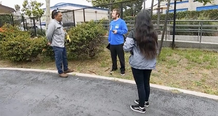
(L to R): San Marcos USD groundskeeper Xavier McCurry, Austin Black, and Arlene Acosta of WaterWise Consulting discuss the water audit. Photo: Vallecitos Water District
Surveyors also adjust existing sprinklers for maximum efficiency and compile a list of repairs and upgrades to improve water use efficiency.
“In our effort to be good stewards of all resources used by the district, the decision to participate was an easy one,” said Ted Norman, SMUSD executive director of maintenance and operations. “We will review all our options and implement as many of the recommendations as we can. It’s a win for everyone.”
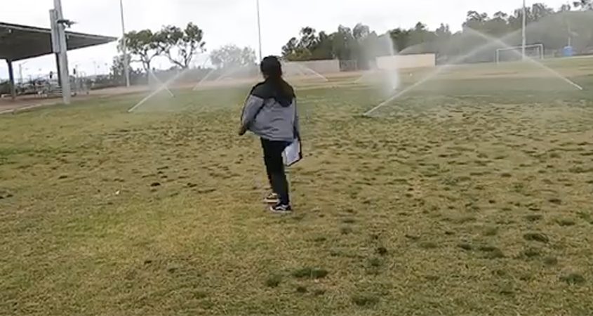
Water Conservation Specialist Arlene Acosta of WaterWise Consulting assesses irrigation coverage at San Marcos Elementary School. Photo: Vallecitos Water District
In one example, the audit report provided to the district for the San Marcos Elementary School estimates that implementing the recommended water-saving measures can reduce landscape water use by approximately 252,000 gallons. Project cost savings are $1,363 annually. If similar savings are achieved at 17 schools, this reflects significant net savings to taxpayers.
“We will submit the reports, and the district can make the changes as they wish,” said Black. “The goal is to create water savings for the entire district and the [water] agency as well.”
MWD can assign a consultant to work with SMUSD and other customers after the audit is completed to help prioritize changes recommended in the survey. The consultant services are free.
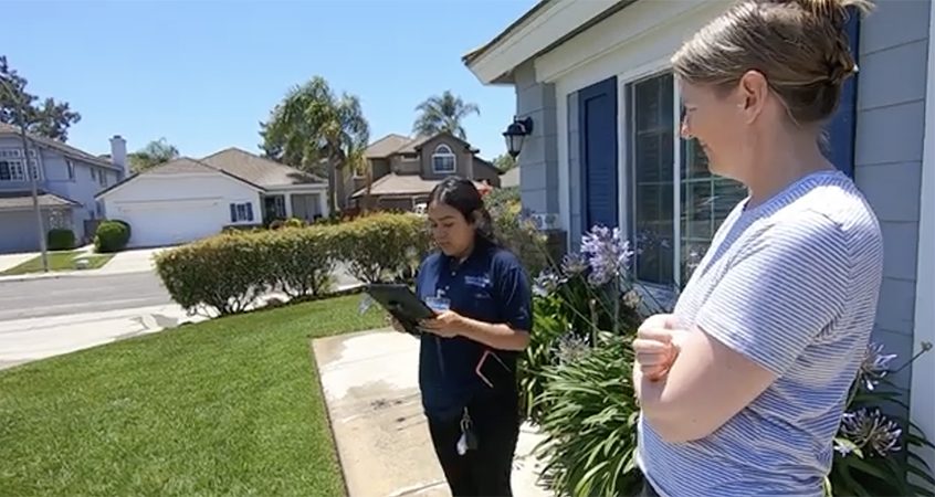
Water Conservation Specialist Arlene Acosta of WaterWise Consulting conducts a residential audit. Photo: Vallecitos Water District
Homeowners can also take advantage of free surveys. Residential surveys look at both indoor and outdoor home water use.
“It’s a comprehensive survey checking for leaks and ways we can make the household more efficient,” said Black.
Along with irrigation improvements, the residential audit reviews the replacement of inefficient plumbing fixtures and other simple adjustments.
Customers of any of the San Diego County Water Authority’s 24 member agencies can visit the website waterefficiencysurvey.com. Enter home address to determine if your residence is located in a qualified area.
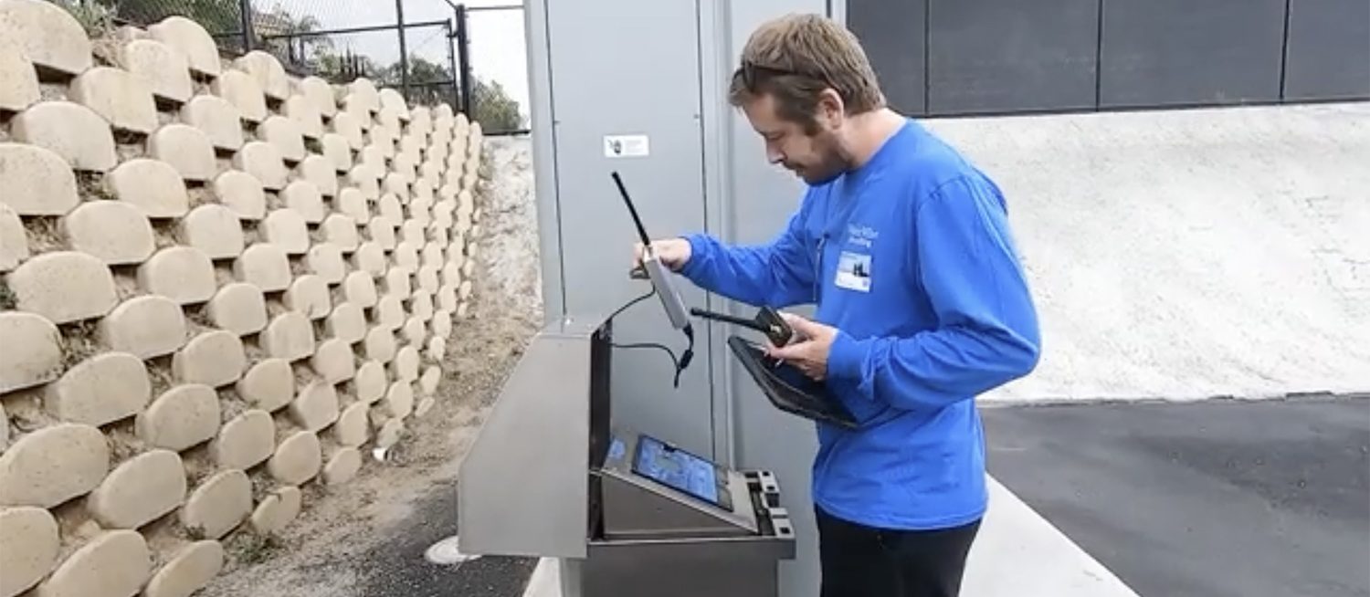
Austin Black with WaterWise Consulting monitors usage during a water audit at San Marcos Elementary School. Photo: Vallecitos Water District
A certified landscape irrigation auditor will schedule a survey and provide written recommendations for qualifying properties. Participants will receive a written report that includes the following:
Surveys are scheduled on a first-come, first-served basis. Applying does not guarantee a survey will be provided. Properties may only receive one survey for the life of the program. After filling out an online application the next step is scheduling a visit from a certified landscape auditor.
San Diego County residents can also take advantage of savings with rebates on a variety of water-saving technologies such as high-efficiency clothes washers and toilets, rain barrels and irrigation nozzles.
(Editor’s note: The Vallecitos Water District is one of the San Diego County Water Authority’s 24 member agencies that deliver water across the San Diego County region.)
Nearly 200 million people in the United States, or 60% of the U.S. population, are under a heat advisory or flood warning or watch and have been since Thursday, according to the National Weather Service.
For nearly a month, millions of people across the American Southwest have sizzled, sweated and sweltered under a heat wave that refuses to let up.
Day after day, residents from Fresno to Phoenix have endured triple-digit temperatures and hot, restless nights that have offered little relief.
Helix Water District received recognition from The Climate Registry as a Water-Energy Leader Gold organization after the district reduced its electric use by 15% and greenhouse gas emissions by 40%.
The Climate Registry is a nonprofit organization that helps companies, governments, and institutions reduce their emissions. Its Water-Energy Nexus Registry is sponsored by the California Environmental Protection Agency and allows utilities and cities to measure, track, and mitigate greenhouse gas emissions associated with California’s water system.

