Widespread rain returns to San Diego County Thursday for a fifth day in a row as yet another atmospheric river impacts our state. Gov. Gavin Newsom has proclaimed a state of emergency throughout California in response to severe winter storms.
https://www.waternewsnetwork.com/wp-content/uploads/2024/04/WNN-Horizontal-White-Blue2.png00Mike Leehttps://www.waternewsnetwork.com/wp-content/uploads/2024/04/WNN-Horizontal-White-Blue2.pngMike Lee2023-01-05 10:13:062023-01-05 10:23:03Strong Pacific Storm Brings Heavy Rain, Wind and Surf to San Diego
A successive series of powerful atmospheric river storms poses a growing threat to California as the ground becomes more saturated, river levels rise and heavy winds threaten the power infrastructure. This week’s storms are expected to dump intense levels of rain in a fairly short period of time. The greatest potential for disaster is in Northern California, which has already been battered by several destructive storms — including one this weekend that caused a deadly levee breach.
https://www.waternewsnetwork.com/wp-content/uploads/2024/04/WNN-Horizontal-White-Blue2.png00Mike Leehttps://www.waternewsnetwork.com/wp-content/uploads/2024/04/WNN-Horizontal-White-Blue2.pngMike Lee2023-01-04 09:54:422023-01-04 09:56:15String of Brutal Atmospheric Rivers Imperils a California Already Weakened by Drought
A team led by Kristen Guirguis, a climate researcher at Scripps Institution of Oceanography at UC San Diego, found evidence that the risk of hazardous weather is increasing in the Southwest.
The researchers investigated the daily relationships among four major modes of weather affecting California. How they interact governs the formation of weather events such as atmospheric rivers capable of bringing torrential rains and Santa Ana winds that can spread devastating wildfires.
“This study suggests that weather patterns are changing in a way that enhances hot, dry Santa Ana winds, while reducing precipitation frequency in the Southwest,” said Guirguis. “These changes in atmospheric circulation are raising the risk of wildfires during California winters.”
Dillard Road is flooded near the Hwy 99 off ramp, located south of Elk Grove, California. Photo credit: Florence Low / California Department of Water Resources.
The basis of the research was an examination of the dominant atmospheric circulation patterns over the North Pacific Ocean, known as Baja-Pacific, Alaskan-Pacific, Canadian-Pacific, and Offshore-California modes. What distinguishes them from each other are the relative positions of ridges and troughs in the atmosphere.
Weather patterns and a warmer atmosphere
The research team identified 16 recurring weather patterns that are created daily as these modes interact with each other. One product of the work was a summary of California weather patterns from 1949 to 2017. The patterns associated with the formation of dry gusty Santa Ana winds that often stoke Southern California fires are becoming more frequent. Patterns associated with what might be considered “normal” rainfall are decreasing in the Southwest thus promoting drought, but patterns associated with extreme precipitation and strong atmospheric river episodes have remained steady over the study period. The researchers noted that while the patterns associated with heavy precipitation and strong atmospheric rivers have not changed in frequency, a warmer atmosphere is capable of holding more water so these storms are becoming more damaging.
Challenges for wildfire and water resource management
The results suggest an increasing probability of compounding environmental hazards during California winters, said the research team. Though winter atmospheric rivers are the antithesis of hot, dry Santa Ana wind conditions, sequences of wildfires followed by strong atmospheric rivers often compound the damage from fires when they trigger flash floods and destructive debris flows from burn scars.
Photo of the Thomas Fire taken from a Santa Barbara beach. Photo credit: Carsten Schertzer / iStock.
“This spells challenges for wildfire and water resource management and provides observational support to our previous results projecting that California will increasingly have to depend on potentially hazardous atmospheric rivers and floodwater for water resource generation in a warming climate,” said study co-author Alexander Gershunov, a Scripps Oceanography climate scientist.
Study authors say this work is helping to inform an experimental subseasonal-to-seasonal (S2S) forecast product being developed at Scripps Oceanography’s Center for Western Weather and Water Extremes (CW3E) that predicts extreme weather in California including atmospheric river landfalls, Santa Ana winds, drought, and heat waves.
The U.S. Department of the Interior via the Bureau of Reclamation and the Southwest Climate Adaptation Science Center, the California Department of Water Resources, and the Regional Integrated Sciences and Assessments (RISA) California—Nevada Climate Applications Program and the International Research Applications Program of the National Oceanic and Atmospheric Administration funded the study. Additional funding was provided by the University of California Office of the President MRPI grant.
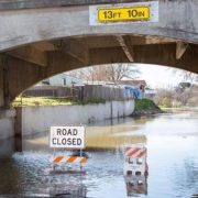
High water levels on the Tuolumne River close River Road in the city of Modesto, California, part of Stanislaus County. Photo credit: Dale Kolke / California Department of Water Resources.
The San Diego County Water Authority has a partnership with the Scripps Institution of Oceanography at UC San Diego to better predict atmospheric rivers and improve water management before, during and after seasonal storms.
(Editors Note: Study co-authors include Benjamin Hatchett of the Desert Research Institute in Nevada; Tamara Shulgina, Michael DeFlorio, Rosana Aguilera, achel Clemesha, Tom Corringham, Luca Delle Monache, and Marty Ralph of CW3E at Scripps Oceanography; Aneesh Subramanian and David Reynolds of the University of Colorado Boulder; Janin Guzman-Morales of the University of California Santa Barbara; and Alex Tardy and Ivory Small of the National Weather Service.)
https://www.waternewsnetwork.com/wp-content/uploads/2022/08/Flooding-primary-photo-UCSD-study.jpg450845Mike Leehttps://www.waternewsnetwork.com/wp-content/uploads/2024/04/WNN-Horizontal-White-Blue2.pngMike Lee2022-08-12 13:16:102022-08-12 13:16:10More Evidence that California Weather is Trending Toward Extremes
Light rain started falling Sunday evening in the Bay Area, as a week of much-needed precipitation was forecast for the parched Northern California landscape.
One to 2 inches of rain is expected to fall across the Bay Area over the next week, and even more could fall across the North Bay as a series of storms dives in from the northwest, said Rick Canepa, meteorologist with the National Weather Service. To the east, parts of the Sierra Nevada could see more than a half-foot of snow by Monday morning.
https://www.waternewsnetwork.com/wp-content/uploads/2024/04/WNN-Horizontal-White-Blue2.png00Chelsea Camposhttps://www.waternewsnetwork.com/wp-content/uploads/2024/04/WNN-Horizontal-White-Blue2.pngChelsea Campos2021-10-18 10:22:282021-10-18 10:52:48Much-needed Rain Finally Falling in the Bay Area; Snow in the Sierra
The weather forecast today calls for sunshine across the state, with barely a cloud on the horizon for the next week or so.
Pour yourself a nice, cool glass of water — and then think about how you’re going to start conserving it.
The lack of rain and snow during what is usually California’s wet season has shrunk the state’s water supply. The Sierra Nevada snowpack, a crucial source of water as it melts over the spring and summer, is currently at 65 percent of normal. Major reservoirs are also low.
https://www.waternewsnetwork.com/wp-content/uploads/2024/04/WNN-Horizontal-White-Blue2.png00Chelsea Camposhttps://www.waternewsnetwork.com/wp-content/uploads/2024/04/WNN-Horizontal-White-Blue2.pngChelsea Campos2021-03-29 10:16:062021-03-29 10:18:41Water Shortages and Fires Loom After a Dry Winter
Flooding rains and record snow in California last week marked another extreme swing of the state’s climate pendulum. The widespread downpours triggered mudslides that damaged homes and roads near some of the huge fire scars from last summer, and also brought some of the water the state will need to end a months-long hot and dry streak and douse a record-setting wildfire season that extended into January.
https://www.waternewsnetwork.com/wp-content/uploads/2024/04/WNN-Horizontal-White-Blue2.png00Mike Leehttps://www.waternewsnetwork.com/wp-content/uploads/2024/04/WNN-Horizontal-White-Blue2.pngMike Lee2021-02-02 10:00:302021-02-02 10:01:22A Surge From an Atmospheric River Drove California’s Latest Climate Extremes
In 2020, Californians endured the hottest August, September and October since 1895. Climate scientists warn the trends are evidence of a warming planet. Rising temperatures combined with less rain and high winds have worsened the chance of extreme fire weather.
The autumn equinox was at 6:30 a.m. PDT on Tuesday, meaning there are nearly equal periods of daylight and darkness. From now until the winter solstice in December, days will gradually get shorter and nights will get longer in the Northern Hemisphere.
https://www.waternewsnetwork.com/wp-content/uploads/2024/04/WNN-Horizontal-White-Blue2.png00Mike Leehttps://www.waternewsnetwork.com/wp-content/uploads/2024/04/WNN-Horizontal-White-Blue2.pngMike Lee2020-09-24 09:57:212020-09-28 11:12:42Fall in Southern California Begins the Race Between Rains and Santa Ana Winds

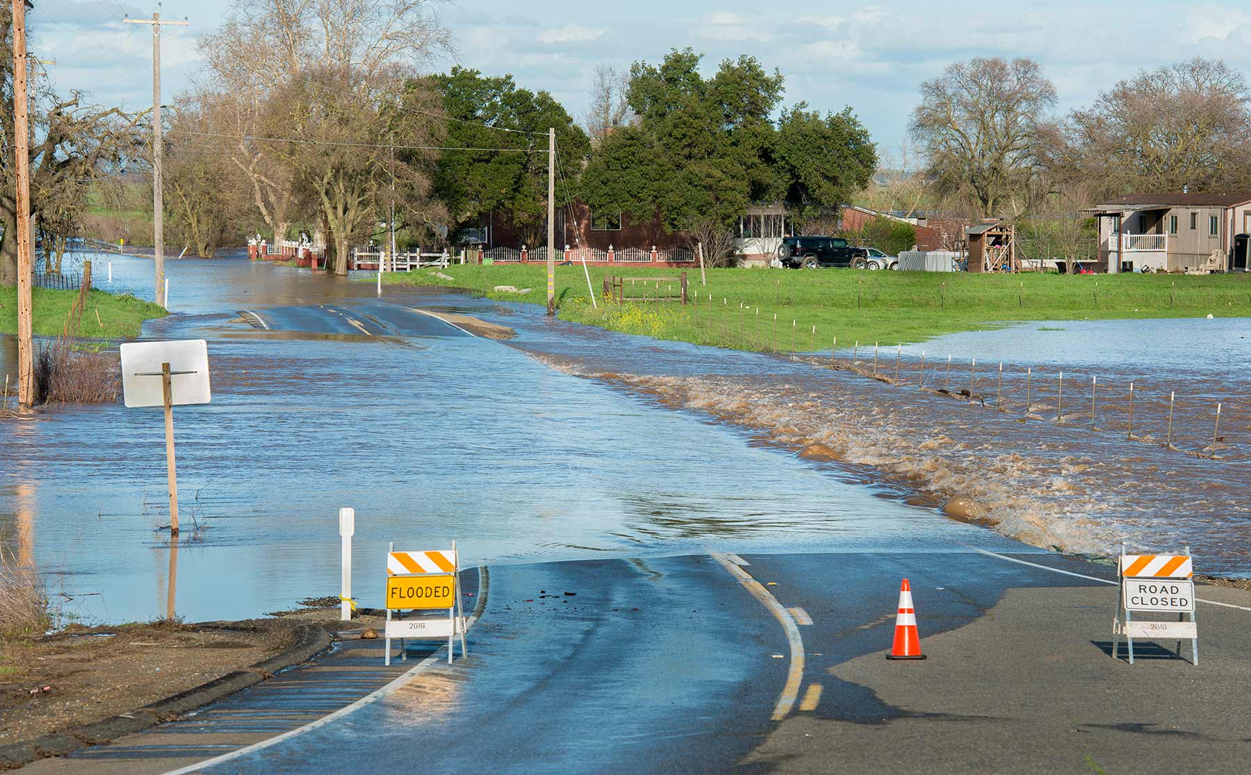 Dillard Road is flooded near the Hwy 99 off ramp, located south of Elk Grove, California. Photo credit: Florence Low / California Department of Water Resources.
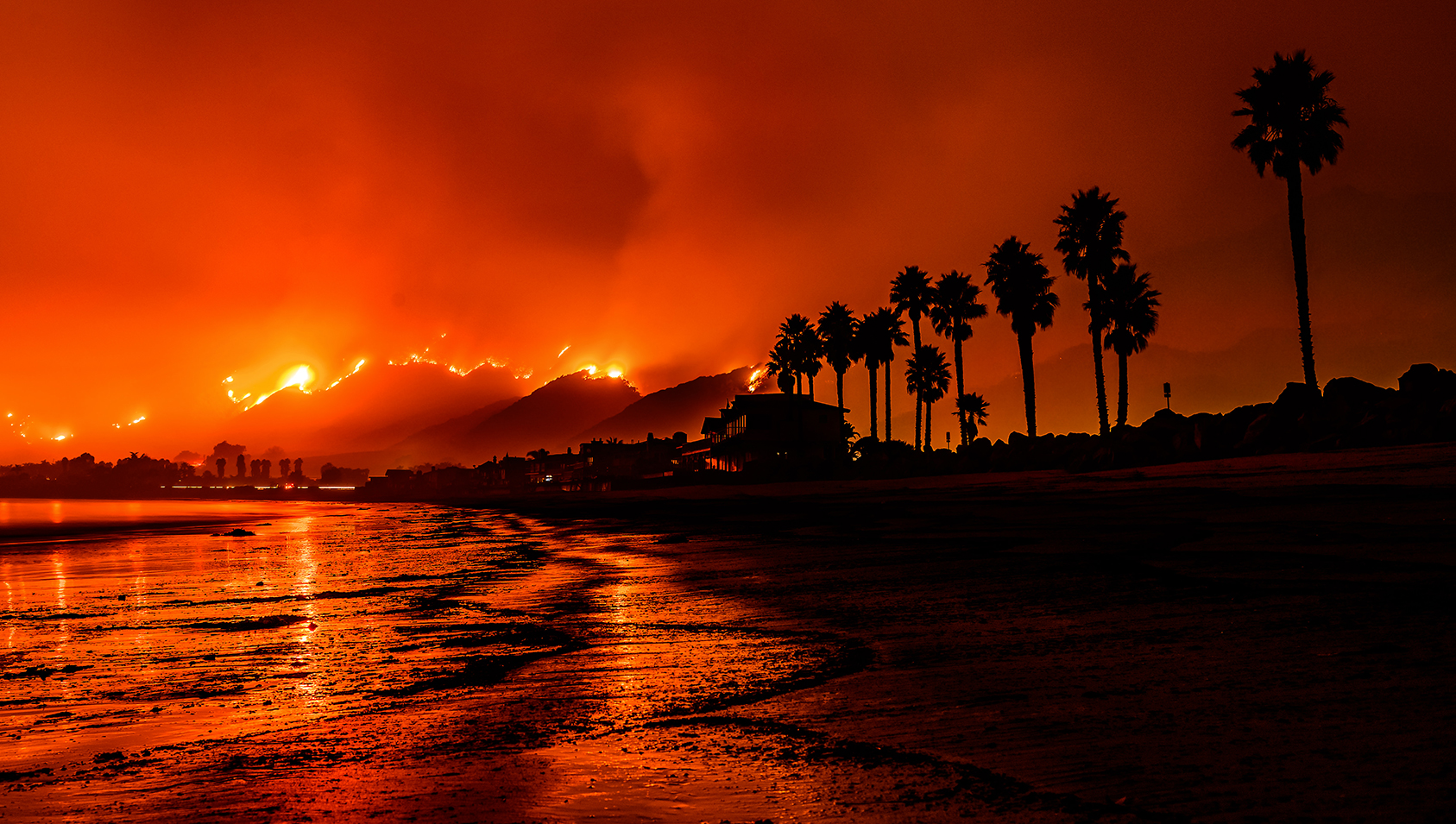 Photo of the Thomas Fire taken from a Santa Barbara beach. Photo credit: Carsten Schertzer / iStock.
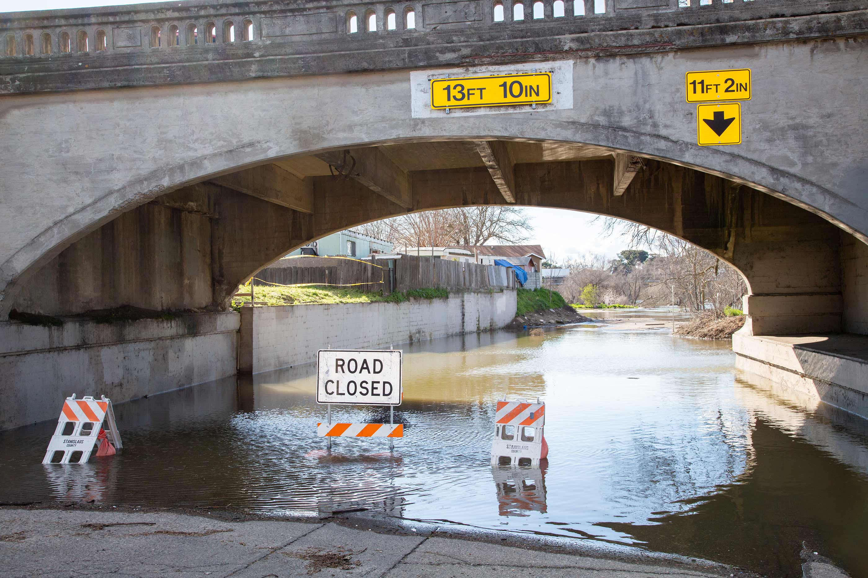 High water levels on the Tuolumne River close River Road in the city of Modesto, California, part of Stanislaus County. Photo credit: Dale Kolke / California Department of Water Resources.
