Posts

El Niño-NOAA-Northern Hemisphere-Winter

El Niño Anticipated to Continue Through the Northern Hemisphere Winter

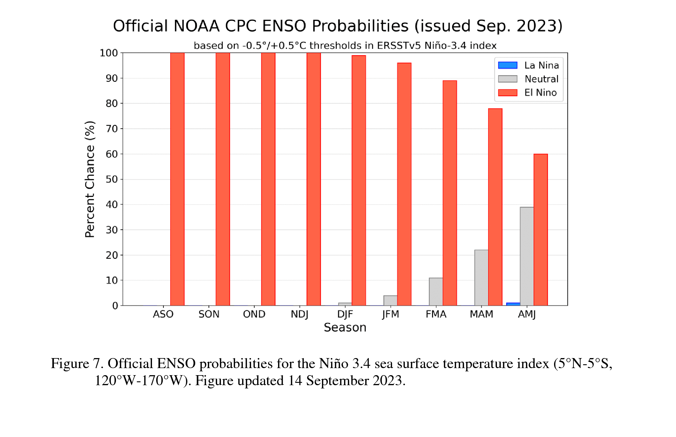
El Niño is anticipated to continue through the Northern Hemisphere winter (with a greater than 95% chance through January – March 2024). An El Niño Advisory remains in effect.

In August, sea surface temperatures (SSTs) were above average across the equatorial Pacific Ocean [Fig. 1], with strengthening in the central and east-central Pacific. All of the latest weekly Niño indices were in excess of +1.0°C: Niño-4 was +1.1°C, Niño-3.4 was +1.6°C, Niño-3 was +2.2°C, and Niño1+2 was +2.9°C [Fig. 2]. Area-averaged subsurface temperatures anomalies increased compared to July [Fig. 3] in association with anomalous warmth in the central and eastern equatorial Pacific Ocean [Fig. 4]. Tropical atmospheric anomalies were also consistent with El Niño. Over the east-central Pacific, low-level winds were anomalously westerly, while upper-level winds were anomalously easterly. Convection was slightly enhanced around the International Date Line, stretching into the eastern Pacific, just north of the equator. Convection was mostly suppressed around Indonesia [Fig. 5]. The equatorial Southern Oscillation Index (SOI) and the traditional station-based SOI were both significantly negative. Collectively, the coupled ocean-atmosphere system reflected El Niño.

El Niño Winter

The most recent IRI plume indicates El Niño will persist through the Northern Hemisphere winter 2023-24 [Fig. 6]. Despite nearly the same ensemble mean amplitude as last month, the shorter forecast horizon means that the odds of at least a “strong” El Niño (≥1.5°C for the November-January seasonal average in Niño-3.4) have increased to 71%. However, a strong El Niño does not necessarily equate to strong impacts locally, with the odds of related climate anomalies often lower than the chances of El Niño itself (e.g., CPC’s seasonal outlooks). In summary, El Niño is anticipated to continue through the Northern Hemisphere winter (with greater than 95% chance through January – March 2024; [Fig. 7]).

Next El Niño update in October

This discussion is a consolidated effort of the National Oceanic and Atmospheric Administration (NOAA), NOAA’s National Weather Service, and their funded institutions. Oceanic and atmospheric conditions are updated weekly on the Climate Prediction Center web site (El Niño/La Niña Current Conditions and Expert Discussions). Additional perspectives and analysis are also available in an ENSO blog. A probabilistic strength forecast is available here. The next ENSO Diagnostics Discussion is scheduled for 12 October 2023.
El Niño

El Niño is anticipated to continue through the Northern Hemisphere winter (with a greater than 95% chance through January – March 2024). An El Niño Advisory remains in effect. Graphic: NOAA

Full discussion on the latest El Niño update from the National Weather Service Climate Prediction Center: www.cpc.ncep.noaa.gov/products/analysis_monitoring/enso_advisory/ensodisc.shtml

 

Dramatic Weather Swings Are Headed to California. Here’s What to Expect in June

The curling of the jet stream — an atmospheric stream of fast-moving air with speeds over 100 mph that travels thousands of miles — over the Pacific Ocean has triggered recent shifts in California’s spring weather patterns. Californians have seen leaps from snowmelt-inducing heat waves in the Sierra Nevada to marine layer clouds that stretch from the Bay Area to Sacramento.

Opinion: California’s Snow Is Melting, and It’s a Beautiful Thing

My fellow Californians often remark that the weather in this state feels like it has been reduced to two seasons, both defined by natural disasters: In summer and fall, huge, intense wildfires rip their way across dry land, while winter and early spring bring intense atmospheric rivers with heavy rainfall, floods and landslides along with winds that take down trees.

6 Common Misconceptions About El Niño and Its Impact on California Weather

After a four-year hiatus, El Niño is widely expected to make a grand reentrance this summer, ushering in the possibility of yet another wet, stormy winter.

“It looks like it’s full steam ahead,” UCLA climate scientist Daniel Swain said in a live YouTube interview last week, in which he placed the likelihood of a strong El Niño event at greater than 50% — even as projections still vary widely.

Opinion: El Niño is Back. What Does That Mean for an Already Overheated California?

During the El Niño of 1983, Californians counted their blessings. The warm Pacific waters sloshing eastward certainly brought heavy spring rains and record snow. But the state largely escaped the flood risks being frantically managed farther east.

California Snowpack Soars to Nearly 200% of Normal

While many areas of California are coping with the destructive impact of relentless rainfall, the news is nothing but good when it comes to the state’s snowpack. As of Monday, California’s snow water equivalent was 199% of normal for the date (January 9), according to the California Department of Water Resources.

California Reservoir Water Levels Before and After Rain

California’s major reservoirs have seen significant gains in water level in recent days after two weeks of exceptionally heavy rain across the state. It comes after months of severe drought in the region, leaving water levels in the state’s most important reservoirs well below their historical average.

Strong Pacific Storm Brings Heavy Rain, Wind and Surf to San Diego

Widespread rain returns to San Diego County Thursday for a fifth day in a row as yet another atmospheric river impacts our state. Gov. Gavin Newsom has proclaimed a state of emergency throughout California in response to severe winter storms.

String of Brutal Atmospheric Rivers Imperils a California Already Weakened by Drought

A successive series of powerful atmospheric river storms poses a growing threat to California as the ground becomes more saturated, river levels rise and heavy winds threaten the power infrastructure. This week’s storms are expected to dump intense levels of rain in a fairly short period of time. The greatest potential for disaster is in Northern California, which has already been battered by several destructive storms — including one this weekend that caused a deadly levee breach.

California weather-extremes-wildlfires-flooding

More Evidence that California Weather is Trending Toward Extremes

A team led by Kristen Guirguis, a climate researcher at Scripps Institution of Oceanography at UC San Diego, found evidence that the risk of hazardous weather is increasing in the Southwest.

The researchers investigated the daily relationships among four major modes of weather affecting California. How they interact governs the formation of weather events such as atmospheric rivers capable of bringing torrential rains and Santa Ana winds that can spread devastating wildfires.

“This study suggests that weather patterns are changing in a way that enhances hot, dry Santa Ana winds, while reducing precipitation frequency in the Southwest,” said Guirguis. “These changes in atmospheric circulation are raising the risk of wildfires during California winters.”

The study, “Winter wet—dry weather patterns driving atmospheric rivers and Santa Ana winds provide evidence for increasing wildfire hazard in California,” was published in the journal Climate Dynamics July 17, 2022.

Flooding in Elk Grove, California.Dillard Road is flooded near the Hwy 99 off ramp, located south of Elk Grove, California. Photo credit: Florence Low / California Department of Water Resources.

The basis of the research was an examination of the dominant atmospheric circulation patterns over the North Pacific Ocean, known as Baja-Pacific, Alaskan-Pacific, Canadian-Pacific, and Offshore-California modes. What distinguishes them from each other are the relative positions of ridges and troughs in the atmosphere.

Weather patterns and a warmer atmosphere

The research team identified 16 recurring weather patterns that are created daily as these modes interact with each other. One product of the work was a summary of California weather patterns from 1949 to 2017. The patterns associated with the formation of dry gusty Santa Ana winds that often stoke Southern California fires are becoming more frequent. Patterns associated with what might be considered “normal” rainfall are decreasing in the Southwest thus promoting drought, but patterns associated with extreme precipitation and strong atmospheric river episodes have remained steady over the study period. The researchers noted that while the patterns associated with heavy precipitation and strong atmospheric rivers have not changed in frequency, a warmer atmosphere is capable of holding more water so these storms are becoming more damaging.

Challenges for wildfire and water resource management

The results suggest an increasing probability of compounding environmental hazards during California winters, said the research team. Though winter atmospheric rivers are the antithesis of hot, dry Santa Ana wind conditions, sequences of wildfires followed by strong atmospheric rivers often compound the damage from fires when they trigger flash floods and destructive debris flows from burn scars.

Photo of the Thomas Fire taken from a Santa Barbara beach. Photo credit: Carsten Schertzer / iStock.

“This spells challenges for wildfire and water resource management and provides observational support to our previous results projecting that California will increasingly have to depend on potentially hazardous atmospheric rivers and floodwater for water resource generation in a warming climate,” said study co-author Alexander Gershunov, a Scripps Oceanography climate scientist.

Study authors say this work is helping to inform an experimental subseasonal-to-seasonal (S2S) forecast product being developed at Scripps Oceanography’s Center for Western Weather and Water Extremes (CW3E) that predicts extreme weather in California including atmospheric river landfalls, Santa Ana winds, drought, and heat waves.

The U.S. Department of the Interior via the Bureau of Reclamation and the Southwest Climate Adaptation Science Center, the California Department of Water Resources, and the Regional Integrated Sciences and Assessments (RISA) California—Nevada Climate Applications Program and the International Research Applications Program of the National Oceanic and Atmospheric Administration funded the study. Additional funding was provided by the University of California Office of the President MRPI grant.

High water levels on the Tuolumne River close River Road in the city of Modesto, California.High water levels on the Tuolumne River close River Road in the city of Modesto, California, part of Stanislaus County. Photo credit: Dale Kolke / California Department of Water Resources.

The San Diego County Water Authority has a partnership with the Scripps Institution of Oceanography at UC San Diego to better predict atmospheric rivers and improve water management before, during and after seasonal storms.

(Editors Note: Study co-authors include Benjamin Hatchett of the Desert Research Institute in Nevada; Tamara Shulgina, Michael DeFlorio, Rosana Aguilera, achel Clemesha, Tom Corringham, Luca Delle Monache, and Marty Ralph of CW3E at Scripps Oceanography; Aneesh Subramanian and David Reynolds of the University of Colorado Boulder; Janin Guzman-Morales of the University of California Santa Barbara; and Alex Tardy and Ivory Small of the National Weather Service.)