San Diego water managers are working with local researchers to understand how atmospheric rivers bring water to the region.
The moisture-laden storm systems bring rain to Southern California, but too much rain can be damaging.
Scripps Institution of Oceanography researchers are working to better understand atmospheric rivers, or ARs, so they can predict when and where the weather systems will hit.
https://www.waternewsnetwork.com/wp-content/uploads/2024/04/WNN-Horizontal-White-Blue2.png00Mike Leehttps://www.waternewsnetwork.com/wp-content/uploads/2024/04/WNN-Horizontal-White-Blue2.pngMike Lee2020-09-02 10:32:562020-09-10 09:19:07San Diego Water Managers Seek Better Rain Forecast Information
The San Diego County Water Authority announced today it is partnering with the Scripps Institution of Oceanography at UC San Diego to better predict atmospheric rivers and improve water management before, during and after those seasonal storms.
https://www.waternewsnetwork.com/wp-content/uploads/2024/04/WNN-Horizontal-White-Blue2.png00Chelsea Camposhttps://www.waternewsnetwork.com/wp-content/uploads/2024/04/WNN-Horizontal-White-Blue2.pngChelsea Campos2020-08-26 10:22:462020-09-03 12:48:12San Diego County Water Authority Partners with Scripps Institution of Oceanography
The San Diego County Water Authority announced Monday it is partnering with the Scripps Institution of Oceanography at UC San Diego to better predict atmospheric rivers and improve water management before, during and after those seasonal storms. This month, Scripps’ Center for Western Weather and Water Extremes launched the Water Affiliates Group, which brings together science and hands-on water industry experience to enhance reservoir operations in light of the changing climate. The water authority has a long-running alliance with Scripps.
https://www.waternewsnetwork.com/wp-content/uploads/2024/04/WNN-Horizontal-White-Blue2.png00Kimberlyn Velasquezhttps://www.waternewsnetwork.com/wp-content/uploads/2024/04/WNN-Horizontal-White-Blue2.pngKimberlyn Velasquez2020-08-25 10:40:592020-08-28 10:27:01San Diego County Water Authority Partners with Scripps Institution of Oceanography
The San Diego County Water Authority is partnering with the Scripps Institution of Oceanography at UC San Diego to better predict atmospheric rivers and improve water management before, during, and after those seasonal storms.
This month, Scripps’ Center for Western Weather and Water Extremes (CW3E) launched the Water Affiliates Group, which brings together cutting-edge science and hands-on water industry experience to enhance reservoir operations in light of the changing climate. The Water Authority has a long-running alliance with Scripps and is among six founding water agencies statewide.
CW3E and its partners will share and support best practices in forecast-informed reservoir operations, increase research around atmospheric rivers and droughts, and develop strategies for mitigating flood risk and increasing water supply reliability.
“This partnership with Scripps Institution of Oceanography underscores our commitment to strategic, science-based decision-making and long-term planning,” said Jim Madaffer, chair of the Water Authority’s Board of Directors. “By supporting advances in forecasting, we can more efficiently and effectively manage water resources both locally and statewide. This ultimately will benefit everyone in California by helping sustain our economy and quality of life.”
Addressing major climate challenges in the arid West
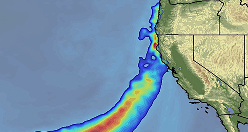
Atmospheric river storms cause 40% to 60% of annual precipitation and most of the flood damage on the West Coast. Graphic: Scripps Institution of Oceanography
Water Authority General Manager Sandra L. Kerl said the collaboration aligns closely with Governor Newsom’s Water Resilience Portfolio, which prioritizes voluntary agreements, smart water storage strategies and coordination of data collection.
“This is a great example of how water agencies are stronger together by addressing major climate challenges that affect everyone across the arid West,” Kerl said. “By combining forces with some of the leading scientists in the world, we will enhance our planning capacity and be ready to adapt to whatever the future brings.”
Atmospheric river storms cause 40% to 60% of annual precipitation and most of the flood damage on the West Coast. Managing reservoirs for both flood control and drinking water supply retention is challenging because 20th-century practices and regulations are decreasingly relevant due to changing patterns for snowmelt and rainfall.
SIO data will help manage water supplies
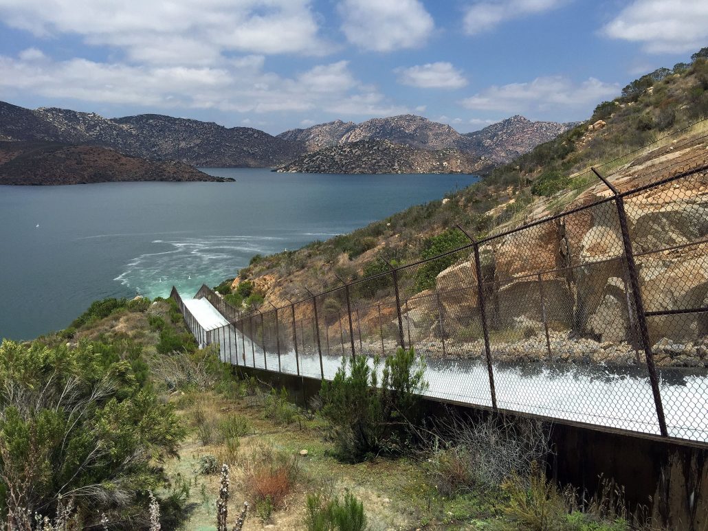
CW3E has numerous tools and technologies that affiliates can use to augment water research and improve on-the-ground decisions of water managers. Photo: San Diego County Water Authority
CW3E is a leader in Forecast Informed Reservoir Operations, which uses data from watershed monitoring and modern weather and water forecasting to help water managers determine the best strategies for retaining or releasing water from reservoirs. CW3E has numerous tools and technologies that affiliates can use to augment water research and improve on-the-ground decisions of water managers. The group’s research covers water supply reliability, flood management, greenhouse gas mitigation, groundwater recharge, public safety, observations, forecasting, decision support, climate outlooks, and hazard assessment.
The Water Authority is working with CW3E to assess how better near-term and long-term precipitation forecasts can improve reservoir planning and operational management in the San Diego region by maximizing local water supplies and the reliability of water resources through a mix of planning processes and real-time decisions.
Joining the Water Authority as founding partners are Sonoma Water, Orange County Water District, Yuba Water Agency, Turlock Irrigation District, and Irvine Ranch Water District.
https://www.waternewsnetwork.com/wp-content/uploads/2020/08/atmospheric-river-NOAA-GOES17-845X450.jpg450845Gayle Falkenthalhttps://www.waternewsnetwork.com/wp-content/uploads/2024/04/WNN-Horizontal-White-Blue2.pngGayle Falkenthal2020-08-24 14:48:492020-08-25 10:42:59Water Authority Joins Scripps Institution of Oceanography to Optimize Water Management
California’s wild weather swings, from pounding rain to drought and from fires to floods, are widely expected to worsen as the climate warms. A new study shows just how severe things might get, and it’s not pretty.
https://www.waternewsnetwork.com/wp-content/uploads/2024/04/WNN-Horizontal-White-Blue2.png00Kimberlyn Velasquezhttps://www.waternewsnetwork.com/wp-content/uploads/2024/04/WNN-Horizontal-White-Blue2.pngKimberlyn Velasquez2020-07-16 10:06:202020-07-21 10:12:53Bigger, Badder Storms Coming In Years Ahead, and California Is Right In Their Path
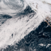
Atmospheric rivers (ARs)—long, sinuous corridors of water vapor in motion in the lower half of Earth’s atmosphere—are a key aspect of California’s cool-season climate. ARs are in many cases pretty unremarkable when they’re out over the open ocean, visible on satellite as a narrow ribbon of cloudiness and (usually) light precipitation. But when these moisture plumes attach themselves to wintertime low pressure systems and make landfall along the California coast, the consequences can be dramatic—prolonged heavy rain and mountain snow often result, along with sometimes powerful winds.
https://www.waternewsnetwork.com/wp-content/uploads/2024/04/WNN-Horizontal-White-Blue2.png00Mike Leehttps://www.waternewsnetwork.com/wp-content/uploads/2024/04/WNN-Horizontal-White-Blue2.pngMike Lee2020-07-16 10:05:282020-07-20 11:31:53Extreme Atmospheric Rivers: What will California’s Strongest Storms Look Like in a Warming Climate?
Precipitation extremes will likely intensify under climate change. However, much uncertainty surrounds intensification of high-magnitude events that are often inadequately resolved by global climate models. In this analysis, we develop a framework involving targeted dynamical downscaling of historical and future extreme precipitation events produced by a large ensemble of a global climate model. This framework is applied to extreme “atmospheric river” storms in California.
https://www.waternewsnetwork.com/wp-content/uploads/2024/04/WNN-Horizontal-White-Blue2.png00Mike Leehttps://www.waternewsnetwork.com/wp-content/uploads/2024/04/WNN-Horizontal-White-Blue2.pngMike Lee2020-07-16 08:26:262020-07-16 09:38:09Future Precipitation Increase from Very High Resolution Ensemble Downscaling of Extreme Atmospheric River Storms in California
California spent 376 weeks in a drought, from December of 2011 until March of 2019. That’s the longest duration of drought we’ve ever seen here in the Golden State. Now a study by Scripps Institution of Oceanography suggests wet and dry extremes in California are likely the result of severe storms called Atmospheric Rivers.
https://www.waternewsnetwork.com/wp-content/uploads/2024/04/WNN-Horizontal-White-Blue2.png00Kimberlyn Velasquezhttps://www.waternewsnetwork.com/wp-content/uploads/2024/04/WNN-Horizontal-White-Blue2.pngKimberlyn Velasquez2020-06-19 10:27:572020-06-24 12:17:56Study Suggests Extreme Weather Conditions in California are a Result of Atmospheric Rivers
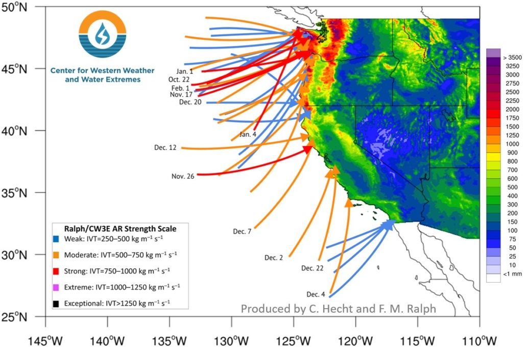
More than three dozen atmospheric rivers made landfall on the West Coast from fall through early spring, but a lack of strong events in California led to the development of drought conditions in parts of the state.
An atmospheric river is a thin, but long plume of moisture in the atmosphere that stretches from the Pacific Ocean tropics or subtropics into higher latitudes. They provide a boost to the rain and snow totals produced by storm systems taking aim at the West Coast, mostly from late fall into early spring. Although these events can bring hazardous impacts, they are also beneficial since they help replenish the water supply in the West.
The Center for Western Weather and Water Extremes at Scripps Institution of Oceanography studies atmospheric rivers and other extreme weather. Graphic: CW3E Scripps/UC San Diego
https://www.waternewsnetwork.com/wp-content/uploads/2024/04/WNN-Horizontal-White-Blue2.png00Mike Leehttps://www.waternewsnetwork.com/wp-content/uploads/2024/04/WNN-Horizontal-White-Blue2.pngMike Lee2020-04-10 10:36:062020-04-13 06:21:58Forty Atmospheric Rivers Have Hit West Coast Since October
Local scientists at Scripps Institution of Oceanography are closely watching a storm system as it moves into Southern California.
Scientists are releasing weather balloons every three hours to study the storm system, classified as an atmospheric river.
“An atmospheric river is just a large amount of moisture that’s associated with the system,” said program analyst Brian Kawzenuk. “An atmospheric river is sort of what it sounds like: it’s a river in the atmosphere.”
The weather balloons will collect a plethora of data including temperature, wind speed, direction and more, allowing scientists to map out a vertical profile of the atmosphere as the system approaches.