California City to Get Nearly Month’s Worth of Rain in Four Days
An approaching storm is expected to soak Southern California this weekend, bringing nearly 2 inches of rain to Los Angeles over four days—nearly the city’s average monthly allotment.
For as long as weather records have been kept, California has been defined by its highly variable climate, with dramatic and sometimes volatile swings between droughts and floods. As human-caused climate change heats up the planet, the state faces even more intense extremes, with increasingly frequent and severe droughts punctuated by stronger and wetter storms.
California is expected to receive more rainfall by Friday from an atmospheric river storm than what Lake Mead in Nevada—the largest reservoir in the U.S.—can hold, meteorologists have said, as the state continues to face the threat of flooding.
All aboard the Pineapple Express this week in California as some coastal ranges could see up to 8 inches of rain before the end of the week, and Los Angeles and San Diego could be in for more monumental flooding.
One reservoir in northern California rose by 5 feet after two atmospheric rivers supplemented the water levels. An atmospheric river began across much of the Pacific Northwest, including Oregon and Northern California, on Friday.
For insight into the numerous atmospheric rivers that brought impressive precipitation accumulations to California this Water Year and how it compares to previous years, the Scripps Institution of Oceanography Center for Western Weather and Water Extremes provides this end of water year 2023 summary.
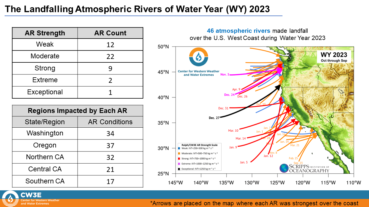
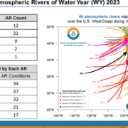
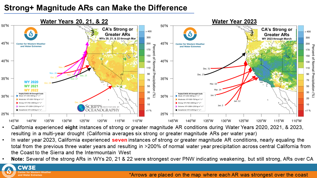
• Water Year 2022 experienced a total of 61 landfalling ARs over the U.S. West Coast, 15 more than Water Year 2023.
• While WY 2022 experienced more ARs, a much larger majority of the ARs only impacted the Pacific Northwest.
• Water Year 2023 was dominated by a more southerly storm track, bringing stronger and more frequent ARs to California compared to the WY 2022
• This variation in storm track and AR distribution resulted in the Pacific Northwest experiencing below normal precipitation and California experiencing well above normal precipitation during WY 2023, a reversal of WY 2022
Analysis by Chad Hecht, Julie Kalansky, & F. Martin Ralph. This analysis is considered experimental.
Legislation signed into law by California Governor Gavin Newsom earlier this year ensures the state has the science and weather forecasting tools it needs for more flexible reservoir operations. The bill, AB 30, makes breakthrough water management technology standard for the California Department of Water Resources.
The legislation was introduced by San Diego Assemblymember Chris Ward and co-sponsored by the Sonoma County Water Agency and the San Diego County Water Authority. The bill was supported by the Water Authority’s partner, UC San Diego’s Scripps Institution of Oceanography.
The strategy is called forecast-informed reservoir operations, or FIRO, and it complements Gov. Newsom’s California Water Supply strategy released in August 2022 calling for more reservoir storage capacity to capture runoff from big storms, often fueled by atmospheric rivers. The governor and Legislature have already provided funding for state water managers to integrate the strategy.
(Editor’s Note: The San Diego County Water Authority has partnered with the Scripps Institution of Oceanography at UC San Diego to better predict atmospheric rivers and improve water management before, during, and after those seasonal storms.)
Legislation signed into law by California Governor Gavin Newsom ensures the state has the science and weather forecasting tools it needs for more flexible reservoir operations. The bill, AB 30, makes breakthrough water management technology standard for the California Department of Water Resources.
The legislation was introduced by San Diego Assemblymember Chris Ward and co-sponsored by the Sonoma County Water Agency and the San Diego County Water Authority. The bill was supported by the Water Authority’s partner, UC San Diego’s Scripps Institution of Oceanography.
The strategy is called forecast-informed reservoir operations, or FIRO, and it complements Gov. Newsom’s California Water Supply strategy released in August 2022 calling for more reservoir storage capacity to capture runoff from big storms, often fueled by atmospheric rivers. The governor and Legislature have already provided funding for state water managers to integrate the strategy.
“We thank Assemblymember Chris Ward for his leadership and vision in supporting next-gen water management and flood reduction efforts that will benefit residents statewide,” said Mel Katz, chair of the San Diego County Water Authority Board of Directors. “The legislation provides an innovative approach to help San Diego County and California thrive in the changing climate.”
Forecast-informed reservoir operations use weather predictions to advise dam operators about how much water to retain or release from reservoirs, enhancing their ability to handle whatever nature serves up while retaining as much water as possible in storage.
Many reservoirs in the West are strictly regulated based on historical averages of winter storms and spring runoff. Under existing rules, the highly variable rainfall from year to year is not directly considered. Complicating the problem, many current guidelines and practices were developed before satellites, radar and advanced numerical models significantly improved weather forecasts.
To address these challenges, researchers at Scripps Institution of Oceanography and elsewhere developed tools that provide weather forecasters with reliable notice of atmospheric rivers a week in advance. Advancing this research could have taken decades, but sophisticated prediction products have evolved in less than 10 years with funding by the San Diego County Water Authority and other water agencies statewide, along with state and federal support.
The Water Authority has partnered with SIO and the Scripps Center for Western Weather and Water Extremes at UC San Diego, to share and support best practices in FIRO, to increase research around atmospheric rivers and droughts, and develop strategies for mitigating flood risk and increasing water supply reliability.
Legislation signed into law by California Governor Gavin Newsom ensures the state has the science and weather forecasting tools it needs for more flexible reservoir operations. The bill, AB 30, makes breakthrough water management technology standard for the California Department of Water Resources.
The legislation was introduced by San Diego Assemblymember Chris Ward and co-sponsored by the Sonoma County Water Agency and the San Diego County Water Authority. The bill was supported by the Water Authority’s partner, UC San Diego’s Scripps Institution of Oceanography.
The strategy is called forecast-informed reservoir operations, or FIRO, and it complements Gov. Newsom’s California Water Supply strategy released in August 2022 calling for more reservoir storage capacity to capture runoff from big storms, often fueled by atmospheric rivers. The governor and Legislature have already provided funding for state water managers to integrate the strategy.
“We thank Assemblymember Chris Ward for his leadership and vision in supporting next-gen water management and flood reduction efforts that will benefit residents statewide,” said Mel Katz, chair of the San Diego County Water Authority Board of Directors. “The legislation provides an innovative approach to help San Diego County and California thrive in the changing climate.”
Forecast-informed reservoir operations use weather predictions to advise dam operators about how much water to retain or release from reservoirs, enhancing their ability to handle whatever nature serves up while retaining as much water as possible in storage.
Many reservoirs in the West are strictly regulated based on historical averages of winter storms and spring runoff. Under existing rules, the highly variable rainfall from year to year is not directly considered. Complicating the problem, many current guidelines and practices were developed before satellites, radar and advanced numerical models significantly improved weather forecasts.
To address these challenges, researchers at Scripps Institution of Oceanography and elsewhere developed tools that provide weather forecasters with reliable notice of atmospheric rivers a week in advance. Advancing this research could have taken decades, but sophisticated prediction products have evolved in less than 10 years with funding by the San Diego County Water Authority and other water agencies statewide, along with state and federal support.
The Water Authority has partnered with SIO and the Scripps Center for Western Weather and Water Extremes at UC San Diego, to share and support best practices in FIRO, to increase research around atmospheric rivers and droughts, and develop strategies for mitigating flood risk and increasing water supply reliability
The 2022–2023 snow season started off relatively active across the West, with a few modest storms bringing snow accumulations to the mountains in early November.
By the start of December, snow water equivalent (SWE) across much of the region was above normal. Starting in early December, several storm cycles brought moisture-laden families of atmospheric rivers to the West Coast. Most of the landfalls occurred in California. The strongest series of storms occurred steadily from December 27 through January 17.
By the end of January, SNOTEL sites across much of the Sierra Nevada, Great Basin, Utah, Arizona, and western Colorado were at >150% of normal SWE. Unlike the 2021–2022 water year, in which snowfall was abundant early in winter but scarce after early January, the storm train continued with another series of strong storms across the West from late February through mid-March.
By April 1, snowpack was above normal across nearly the entire West, with few areas of snow drought. In some parts of the Sierra Nevada, Great Basin, Utah, Arizona, and western Colorado, SWE reached 200%–300% of normal and, in certain locations, set records. The northern Pacific Northwest and northwestern Montana was on the periphery of the storm track during most of winter. In these areas, snow drought developed as snowmelt began, and summer drought conditions are developing or seem likely to develop.
During the past winter, unlike many recent years, anomalously cold temperatures were persistent and widespread. November through March temperatures were among the lowest third of all years since 1895 across much of the West. Temperatures in parts of California, Nevada, Oregon, and Idaho were among the coldest ten percent. Impacts of the cold temperatures included an unusual proportion of precipitation falling as snow compared to rain, snow persisting at lower elevations for longer than usual, and little mid-winter snow melt at higher elevations.
April brought a drying and warming trend to the Southwest and above-normal precipitation and cooler temperatures to Oregon and Washington, reducing some of the snowpack deficits in the Cascade Range. However, the cool and wet conditions in the Pacific Northwest were short-lived. Throughout May and into early June, temperatures across the Pacific Northwest and northern Rocky Mountains were above normal, with record warmth in parts of northern Oregon, Washington, northern Idaho, and northwestern Montana. The warm temperatures combined with relatively dry conditions have led to rapid snow loss across the region, and snow has melted one to three weeks early at many SNOTEL stations (70 sites in Oregon, Washington, Idaho, and Montana melted out more than a week early).
May snowmelt reached record highs across many western regions, not just the Pacific Northwest. However, in terms of drought development, the early snowmelt was only problematic for parts of the Pacific Northwest and northern Rocky Mountains, where snowpack at the beginning of May was near normal or below normal (unlike the near-record snowpack in the Sierra Nevada, Utah, and western Colorado). The rapid snow loss, low winter precipitation, and forecasted below-normal summer runoff have renewed concerns about drought in the Pacific Northwest, with abnormal dryness (D0) and moderate drought (D1) reappearing in portions of western Washington and Oregon over the past three weeks.
Currently, snowpack persists at higher elevations throughout the West and remains remarkably deep for mid-June in parts of the Sierra Nevada and southern Cascade Range. A few notable locations include Leavitt Lake in the central Sierra Nevada, with 92 inches of SWE remaining as of June 12; Lower Lassen Peak in the southern Cascade Range, with 82 inches of SWE remaining; and Mount Rose Ski Area near Lake Tahoe, with 43 inches of SWE remaining.
For California, the Great Basin, and the Colorado River Basin, the cool, wet, and snowy year brought major drought relief after three consecutive dry years. Observed water year runoff in these regions was above normal through early June, and the forecasts indicate above-normal flows persisting throughout summer.
Major reservoirs, with the exception of Lakes Powell and Mead, have already filled or are expected to fill by the end of summer. This year was still beneficial for Lakes Powell and Mead, the two largest reservoirs in the country, but it will take much more than one wet year to refill these reservoirs after over 20 years of falling water levels. The June 12th update from the U.S. Bureau of Reclamation indicated that Lake Powell was at 37% of capacity and Lake Mead was at 31% of capacity, with forecasted April–July inflows into Powell at 167% of normal.
(Editor’s Note: NIDIS and its partners launched this snow drought effort in 2018 to provide data, maps, and tools for monitoring snow drought and its impacts as well as communicating the status of snow drought across the United States, including Alaska. Thank you to our partners for your continued support of this effort and review of these updates. For more information contact: Daniel McEvoy, Western Regional Climate Center, Amanda Sheffield, NOAA/NIDIS California-Nevada Regional Drought Information Coordinator, and Britt Parker, NOAA/NIDIS Pacific Northwest Regional Drought Information Coordinator: www.drought.gov/drought-status-updates/water-year-2023-snow-drought-conditions-summary-and-impacts-west-2023-06-15)