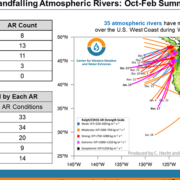
A Scripps Center for Western Weather and Water Extremes report shows that more atmospheric rivers have made landfall over the U.S. West Coast in the first four months of Water Year 2021 compared to the previous period in 2020.
The four months of Water Year 2021 experienced a total of 35 landfalling ARs over the U.S. West Coast, six more than the first four months of Water Year 2020, according to the CW3E quarter year summary released February 11.
Key takeaways from the CW3E update on atmospheric rivers
• The first four months of Water Year 2021 experienced a total of 35 landfalling ARs over the U.S. West Coast, 6 more than the first four months of Water Year 2020.
• Water Year 2021 also experienced more than twice as many strong or greater ARs (14) compared to Water Year 2020 (6).
• While Water Year 2021 saw more ARs in its first 4 months compared to Water Year 2020, a large majority of those ARs were
strongest over the Pacific Northwest (Oregon and Washington).
• The average landfall latitude thus far in Water Year 2021 was 45.9°N compared to 43.9°N during the first half of Water Year 2020.
• The lack of landfalling ARs over Southern California and Baja California has resulted in much drier conditions over the southwestern U.S. compared to WY 2020.
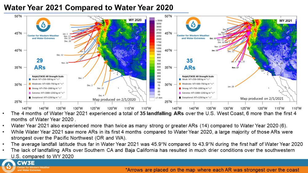
The four months of Water Year 2021 experienced a total of 35 landfalling ARs over the U.S. West Coast, six more than the first four months of Water Year 2020. Graphic: Center for Western Weather and Water Extremes
Distribution of Landfalling Atmospheric Rivers over the U.S. West Coast During Water Year 2021: Quarter Year Summary
A partnership with the San Diego County Water Authority and the Scripps Institution of Oceanography at UC San Diego seeks to optimize water management to better predict atmospheric rivers before, during, and after those seasonal storms.
In August 2020, Scripps Center for Western Weather and Water Extremes (CW3E) launched the Water Affiliates Group, which brings together cutting-edge science and hands-on water industry experience to enhance reservoir operations in light of the changing climate. The Water Authority has a long-running alliance with Scripps and is among six founding water agencies statewide.
CW3E and its partners will share and support best practices in forecast-informed reservoir operations, increase research around atmospheric rivers and droughts, and develop strategies for mitigating flood risk and increasing water supply reliability.
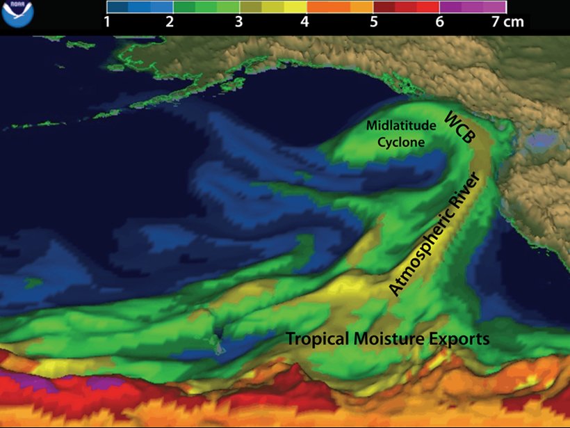
The above image, from the EOS article, is a depiction of an atmospheric river, interacting with West Coast mountains and a midlatitude cyclone over the northeast Pacific on 5 February 2015. This image provides an example of approximate locations of associated tropical moisture exports and a warm conveyor belt (WCB). Graphic: Adapted from NOAA/ESRL Physical Sciences Division via CW3E