For decades, Californians have depended on the reliable appearance of spring and summer snowmelt to provide nearly a third of the state’s supply of water. But as the state gets drier, and as wildfires climb to ever-higher elevations, that precious snow is melting faster and earlier than in years past — even in the middle of winter.
https://www.waternewsnetwork.com/wp-content/uploads/2024/04/WNN-Horizontal-White-Blue2.png00Mike Leehttps://www.waternewsnetwork.com/wp-content/uploads/2024/04/WNN-Horizontal-White-Blue2.pngMike Lee2023-02-14 09:57:552023-02-14 10:00:38California’s Snowpack Is Melting Faster Than Ever, Leaving Less Available Water
Wildfires, drought, extreme heat and other effects of climate change are rapidly accelerating and compounding in California, according to a report from state scientists.
The fourth edition of “Indicators of Climate Change in California,” released Tuesday, paints a stark picture of the escalating climate crisis and documents how global reliance on fossil fuels has had wide-ranging effects on the state’s weather, water and residents.
https://www.waternewsnetwork.com/wp-content/uploads/2024/04/WNN-Horizontal-White-Blue2.png00Mike Leehttps://www.waternewsnetwork.com/wp-content/uploads/2024/04/WNN-Horizontal-White-Blue2.pngMike Lee2022-11-02 10:18:012022-11-02 10:22:47Climate Change is Rapidly Accelerating in California, State Report Says
When Stephanie Kampf visited one of her wildfire test plots near Colorado’s Joe Wright Reservoir in June of 2021, the charred remains of what had been a cool, shady spruce and fir forest before the Cameron Peak Fire incinerated it nearly took her breath away.
Californians sweated it out amid a record-breaking heat wave entering its 10th day Friday that has helped fuel deadly wildfires and pushed energy supplies to the brink of daily power outages.
https://www.waternewsnetwork.com/wp-content/uploads/2024/04/WNN-Horizontal-White-Blue2.png00Mike Leehttps://www.waternewsnetwork.com/wp-content/uploads/2024/04/WNN-Horizontal-White-Blue2.pngMike Lee2022-09-09 10:27:322022-09-09 10:31:25California: Drought, Record Heat, Fires and Now Maybe Floods
As California grapples with drought, a record heat wave and persistent wildfires, one state agency is turning to the beaver in its battle against climate change.
The large rodents, according to researchers, are resourceful engineers capable of increasing water storage and creating natural firebreaks with their dams.
https://www.waternewsnetwork.com/wp-content/uploads/2024/04/WNN-Horizontal-White-Blue2.png00Gayle Falkenthalhttps://www.waternewsnetwork.com/wp-content/uploads/2024/04/WNN-Horizontal-White-Blue2.pngGayle Falkenthal2022-09-07 09:36:132022-09-07 09:36:13When It Comes to Fighting Climate Change, California Says Consider the Beaver
In the foothills of the Rocky Mountains, buzzing chainsaws interrupt the serenity. Crews are hustling to remove charred trees and other debris that have been washing down the mountainsides in the wake of the largest wildfire in New Mexico’s recorded history, choking rivers and streams.
Heavy equipment operators are moving boulders dislodged by the daily torrential summer rains that have followed the flames.
https://www.waternewsnetwork.com/wp-content/uploads/2024/04/WNN-Horizontal-White-Blue2.png00Gayle Falkenthalhttps://www.waternewsnetwork.com/wp-content/uploads/2024/04/WNN-Horizontal-White-Blue2.pngGayle Falkenthal2022-08-23 10:09:462022-08-23 10:16:31NM City, Victim of Government Burn, Now Faces Water Shortage
A team led by Kristen Guirguis, a climate researcher at Scripps Institution of Oceanography at UC San Diego, found evidence that the risk of hazardous weather is increasing in the Southwest.
The researchers investigated the daily relationships among four major modes of weather affecting California. How they interact governs the formation of weather events such as atmospheric rivers capable of bringing torrential rains and Santa Ana winds that can spread devastating wildfires.
“This study suggests that weather patterns are changing in a way that enhances hot, dry Santa Ana winds, while reducing precipitation frequency in the Southwest,” said Guirguis. “These changes in atmospheric circulation are raising the risk of wildfires during California winters.”
https://www.waternewsnetwork.com/wp-content/uploads/2024/04/WNN-Horizontal-White-Blue2.png00Mike Leehttps://www.waternewsnetwork.com/wp-content/uploads/2024/04/WNN-Horizontal-White-Blue2.pngMike Lee2022-08-15 11:14:102022-08-15 11:16:51More Evidence that California Weather is Trending Toward Extremes
A team led by Kristen Guirguis, a climate researcher at Scripps Institution of Oceanography at UC San Diego, found evidence that the risk of hazardous weather is increasing in the Southwest.
The researchers investigated the daily relationships among four major modes of weather affecting California. How they interact governs the formation of weather events such as atmospheric rivers capable of bringing torrential rains and Santa Ana winds that can spread devastating wildfires.
“This study suggests that weather patterns are changing in a way that enhances hot, dry Santa Ana winds, while reducing precipitation frequency in the Southwest,” said Guirguis. “These changes in atmospheric circulation are raising the risk of wildfires during California winters.”
Dillard Road is flooded near the Hwy 99 off ramp, located south of Elk Grove, California. Photo credit: Florence Low / California Department of Water Resources.
The basis of the research was an examination of the dominant atmospheric circulation patterns over the North Pacific Ocean, known as Baja-Pacific, Alaskan-Pacific, Canadian-Pacific, and Offshore-California modes. What distinguishes them from each other are the relative positions of ridges and troughs in the atmosphere.
Weather patterns and a warmer atmosphere
The research team identified 16 recurring weather patterns that are created daily as these modes interact with each other. One product of the work was a summary of California weather patterns from 1949 to 2017. The patterns associated with the formation of dry gusty Santa Ana winds that often stoke Southern California fires are becoming more frequent. Patterns associated with what might be considered “normal” rainfall are decreasing in the Southwest thus promoting drought, but patterns associated with extreme precipitation and strong atmospheric river episodes have remained steady over the study period. The researchers noted that while the patterns associated with heavy precipitation and strong atmospheric rivers have not changed in frequency, a warmer atmosphere is capable of holding more water so these storms are becoming more damaging.
Challenges for wildfire and water resource management
The results suggest an increasing probability of compounding environmental hazards during California winters, said the research team. Though winter atmospheric rivers are the antithesis of hot, dry Santa Ana wind conditions, sequences of wildfires followed by strong atmospheric rivers often compound the damage from fires when they trigger flash floods and destructive debris flows from burn scars.
Photo of the Thomas Fire taken from a Santa Barbara beach. Photo credit: Carsten Schertzer / iStock.
“This spells challenges for wildfire and water resource management and provides observational support to our previous results projecting that California will increasingly have to depend on potentially hazardous atmospheric rivers and floodwater for water resource generation in a warming climate,” said study co-author Alexander Gershunov, a Scripps Oceanography climate scientist.
Study authors say this work is helping to inform an experimental subseasonal-to-seasonal (S2S) forecast product being developed at Scripps Oceanography’s Center for Western Weather and Water Extremes (CW3E) that predicts extreme weather in California including atmospheric river landfalls, Santa Ana winds, drought, and heat waves.
The U.S. Department of the Interior via the Bureau of Reclamation and the Southwest Climate Adaptation Science Center, the California Department of Water Resources, and the Regional Integrated Sciences and Assessments (RISA) California—Nevada Climate Applications Program and the International Research Applications Program of the National Oceanic and Atmospheric Administration funded the study. Additional funding was provided by the University of California Office of the President MRPI grant.
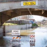
High water levels on the Tuolumne River close River Road in the city of Modesto, California, part of Stanislaus County. Photo credit: Dale Kolke / California Department of Water Resources.
The San Diego County Water Authority has a partnership with the Scripps Institution of Oceanography at UC San Diego to better predict atmospheric rivers and improve water management before, during and after seasonal storms.
(Editors Note: Study co-authors include Benjamin Hatchett of the Desert Research Institute in Nevada; Tamara Shulgina, Michael DeFlorio, Rosana Aguilera, achel Clemesha, Tom Corringham, Luca Delle Monache, and Marty Ralph of CW3E at Scripps Oceanography; Aneesh Subramanian and David Reynolds of the University of Colorado Boulder; Janin Guzman-Morales of the University of California Santa Barbara; and Alex Tardy and Ivory Small of the National Weather Service.)
https://www.waternewsnetwork.com/wp-content/uploads/2022/08/Flooding-primary-photo-UCSD-study.jpg450845Mike Leehttps://www.waternewsnetwork.com/wp-content/uploads/2024/04/WNN-Horizontal-White-Blue2.pngMike Lee2022-08-12 13:16:102022-08-12 13:16:10More Evidence that California Weather is Trending Toward Extremes
As the drought punishing California drags on, water is a top — and growing — worry for residents of our parched state, outpacing wildfires and climate change, according to a new poll about environmental issues.
With reservoirs and snowpack shrinking, Californians listed the state’s water supply as their number one environmental worry, with 68% of adults saying it’s a big problem — up from 63% a year ago.
https://www.waternewsnetwork.com/wp-content/uploads/2024/04/WNN-Horizontal-White-Blue2.png00Mike Leehttps://www.waternewsnetwork.com/wp-content/uploads/2024/04/WNN-Horizontal-White-Blue2.pngMike Lee2022-07-28 09:23:032022-07-28 09:27:02Water Woes Are Biggest Worry for Californians as Drought Drags On
About 200 miles north of Sacramento, the artificial reservoir — formed by a dam on the Sacramento River — is ringed by quiet beaches that offer a cool respite from triple-digit heat. The views of Mt. Shasta are spectacular. When I visited last week, I saw double-crested cormorants, ospreys and great blue herons soaring over the water and ducklings swimming with their mother.

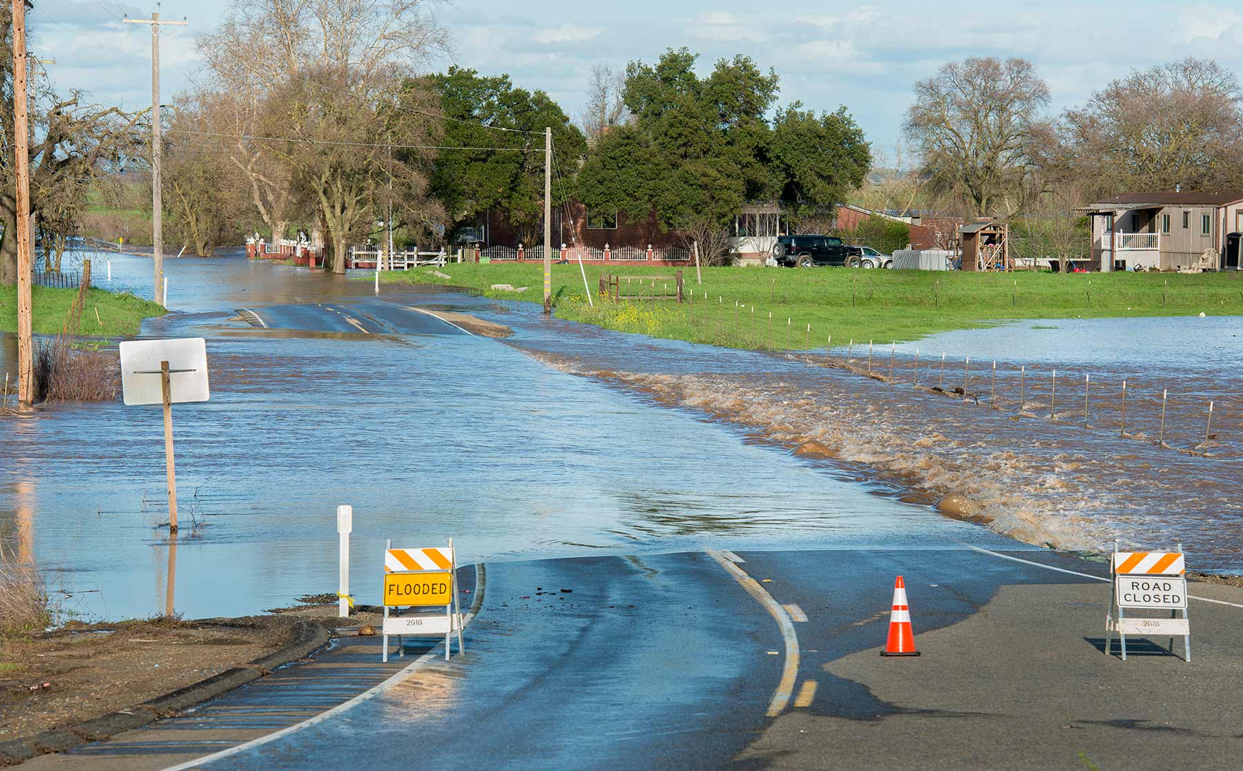 Dillard Road is flooded near the Hwy 99 off ramp, located south of Elk Grove, California. Photo credit: Florence Low / California Department of Water Resources.
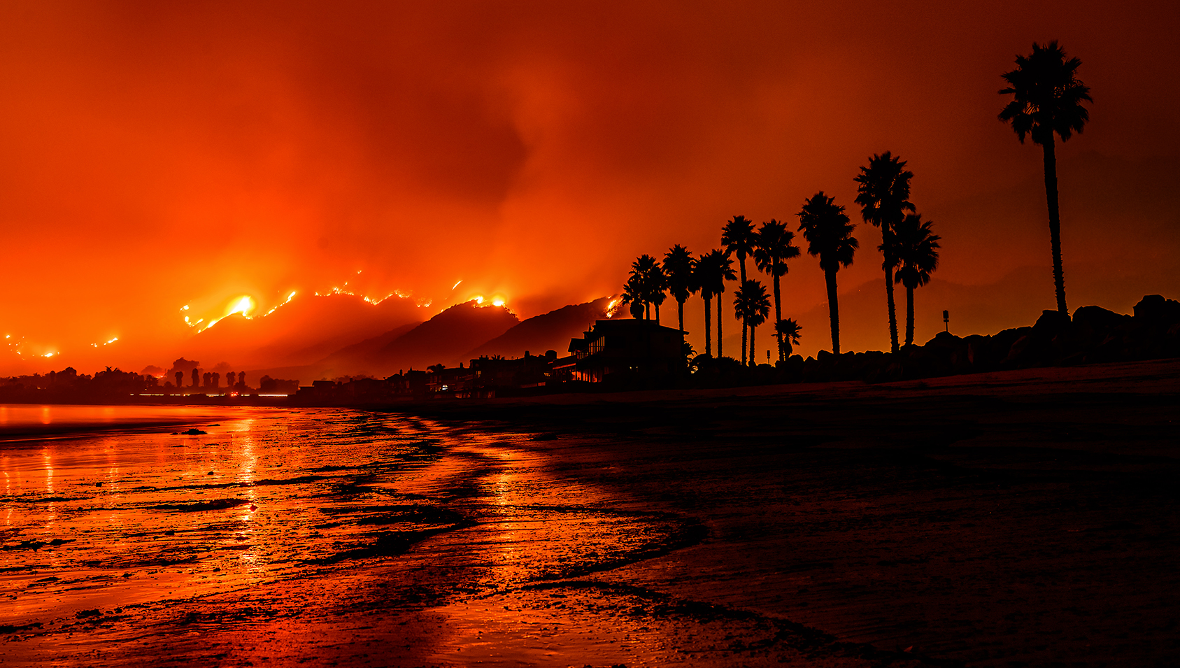 Photo of the Thomas Fire taken from a Santa Barbara beach. Photo credit: Carsten Schertzer / iStock.
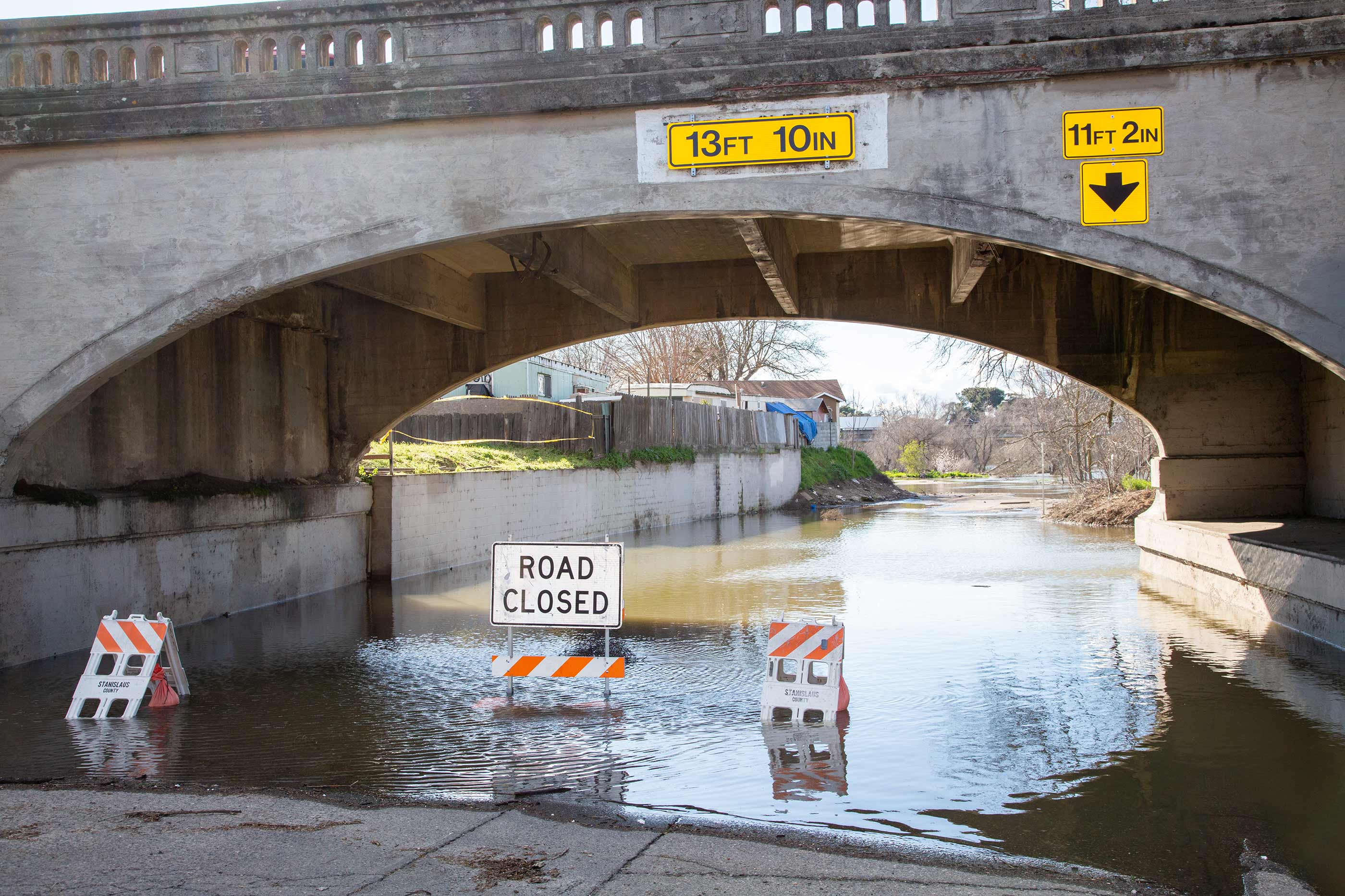 High water levels on the Tuolumne River close River Road in the city of Modesto, California, part of Stanislaus County. Photo credit: Dale Kolke / California Department of Water Resources.
