Tag Archive for: Weather

Before And After: See California’s Monster Snow Year By Satellite

A rolling conveyor belt of storms this winter has left the Sierra Nevada blanketed in a thick layer of snow. The year started modestly, with the snowpack measuring around 70 percent of average on the first of the year. A robust January and February has brought the snowpack up to around 145 percent of normal for this time of year. April 1 typically marks the peak of Sierra snowpack accumulation and the start of the spring runoff. Move the sliders below to view the terrain before and after snowstorms.

Rain, Heavy Snow Expected With Latest Storm In San Diego County

A low-pressure system is expected to reach San Diego County Wednesday, bringing precipitation and the possibility of heavy snowfall in the mountains, according to the National Weather Service. Frigid temperatures this morning prompted the NWS to issue a frost advisory that will last until 9 a.m. in parts of the inland valleys and deserts, including Escondido, Poway, San Marcos, Santee and Borrego Springs. The advisory indicates a likelihood of temperatures dropping to upper-20s to low-30s.

Storms Cause Millions Of Dollars In Damage To California Highways

Recent debris flows and flooding in the San Jacinto and San Bernardino mountains have caused extensive damage to Southern California roadways, requiring some highways to be closed for months as crews work on repairs that will cost at least $14 million. Last week’s series of storms, including a moisture-packed atmospheric river that slammed the state, has brought consistent rainfall to California, dumping 18 trillion gallons of rain — nearly half the volume of Lake Tahoe.

Rare L.A. Mega-Storm Could Overwhelm Dam And Flood Dozens Of Cities, Experts Say

Scientists call it California’s “other big one,” and they say it could cause three times as much damage as a major earthquake ripping along the San Andreas Fault. Although it might sound absurd to those who still recall five years of withering drought and mandatory water restrictions, researchers and engineers warn that California may be due for rain of biblical proportions — or what experts call an ARkStorm.

Monster Storm Pummels California, Prompting Evacuations Amid Mudslides And Flooding

A fierce winter storm packed with subtropical moisture continued its destructive path across California on Thursday, triggering widespread flooding that prompted evacuations and unleashing a mudslide that sent one home sliding into another in Marin County. Southern Marin fire officials said the mudslide dislodged the home from its foundation and pushed it down a hill before it slammed into another residence shortly before 3 a.m.

Record-Breaking Storm Causes Flooding Countywide, Delays Air Traffic; 7 School Districts Cancel Friday Classes

A Pacific storm supercharged by moisture from the subtropics slammed San Diego County on Thursday, flooding streets, snapping trees, closing schools, causing rock slides and delaying commercial airline traffic. The “atmospheric river” streamed ashore from east of Hawaii and dropped more than 10 inches of rain on Palomar Mountain, more than 6 inches in Julian and close to 3.5 inches in Oceanside. The system produced one of wettest winter days in decades, breaking daily rainfall records in seven communities, including Palomar. The mountain received 10.10 inches, snapping the record of 9.58 inches, set on Feb. 14, 1991. Ramona got 4.05 inches, nearly 2 inches higher than a record set in 1995.

Storm Drops 5.5 Inches Of Rain On Palomar, Floods Part Of Fashion Valley, And Buffets Jets With High Winds

A big plume of moisture from the sub-tropics has dropped nearly 6 inches of rain on Palomar Mountain, caused flooding in the Fashion Valley Mall area, and generated strong winds that are shaking commercial jets during takeoffs and landings at San Diego International Airport. Through 6 a.m. Thursday, the winds had hit 37 mph at the airport, 48 mph at Scripps Pier and 69 mph on Palomar Mountain. SeaWord will remained closed throughout the day. The storm intensified before dawn and is unleashing heavy rain countywide, causing hazardous driving and bringing a regional flood advisory that will be in effect until 10:30 p.m.

A snow-covered Sierra Nevada Mountain peak to the northwest from the Phillips Station meadow season. Photo: Dale Kolke / California Department of Water Resources snowmelt

Report: Shorter Winters Could Impact Snowpack and Water Supply

New research shows shorter periods of winter weather are altering snowpack melt times, with potentially significant implications for water management and wildfires.

Associate Professor Amato Evan at UC San Diego’s Scripps Institution of Oceanography analyzed snowpack data from 1982 through 2017, publishing his analysis in the December Journal of Applied Meteorology and Climatology, and presenting his findings at the American Geophysical Union Fall Meeting in Washington, D.C.

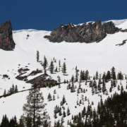
Evan found no decline in snowfall totals overall, but he discovered snow in mountainous regions is disappearing earlier in the year – in line with earlier projections and modeling. California and other western states rely heavily on snowfall and snowpack for water. When the snowpack melts, it fills reservoirs, a vital resource for cities and farms.

If snowmelt occurs more quickly than normal, it could result in reservoirs filling earlier in the winter or spring. If that dynamic isn’t managed correctly, it could result in losing water supply when the reservoirs overflow. Evan noted California would be among the most-affected states.

Investments buffer San Diego region

Three decades of investments to diversify the San Diego region’s water supply sources with seawater desalination, recycled water and other supplies have lessened the local impact of snowpack variations, said Dana Friehauf, water resources manager for the San Diego County Water Authority. The San Diego region relies on snowmelt in the Rockies and the Sierra Nevada, along with a variety of local water resources. In addition, the Water Authority has expanded local water storage by raising San Vicente Dam and more than doubling the reservoir’s capacity. That allows the region to hold more imported supplies during wet years to prepare for dry ones.

“By increasing water-use efficiency and investing in drought-resilient supplies and local storage, the San Diego region is less susceptible to changes in snowmelt,” said Friehauf. “But climatic shifts likely will be an important factor in water management across the West for years to come.”

Researcher observes winter weather declines

Evan used data for his research collected from a network of over 400 snow telemetry sensors across the western U.S. The sensors compress and expand as snow falls and melts, measuring the weight of the snowpack throughout the season. Evan developed a mathematical expression he could apply to the observations which can identify trends in snowpack variations over the course of the winter season.

Evan found two key changes in mountain snowpack consistent across the western U.S. First, warmer fall and spring seasons are “squeezing” winters, making them shorter from a weather perspective.

Second, higher elevations are showing snowpack characteristics normally found at lower altitudes, with a gradual build up and gradual decline. This translates into less snow and earlier melts. While this has been shown in climate model simulations, the Scripps study is the first time it has been observed. Evan’s findings are consistent with numerous other methods of measuring changes in the seasons.

“The power of this work was the ability to examine how and why snowpack is changing throughout the year,” Evan said in a Scripps news release. “In terms of freshwater in the West, the total amount of snow we receive during the year is important, but how long into the spring that snow stays frozen up in the mountains is also critical.”

The Scripps research was supported by funding from the Climate Program Office at the National Oceanic and Atmospheric Administration.

Storm Will Plant A Wet One On San Diego This Valentine’s Day

Not to take the romance out of Valentine’s Day, but this year a sturdy umbrella might be a better gift than chocolate or flowers. The National Weather Service says a huge, warm plume of moisture from the sub-tropics will arrive in San Diego County and drench a region that’s already squishy from earlier storms. The system will begin spreading rain late Wednesday. But the core will hit on Thursday — Valentine’s Day — when the moisture rides up the side of local mountains, condenses, and unleashes heavy rain. Its called orographic lift.

Midweek California Storm To Bury Sierra Nevada Under Yards Of Snow, Bring Flooding Risk

One of the more potent storms of the winter will hit California with heavy rain, excessive mountain snow and gusty winds from Tuesday night to Thursday night. The worst of the storm is forecast to focus on Central and Northern California with a heightened threat of flooding, mudslides, erosion, power outages and avalanches and road-closing snowfall in the mountains.