Last winter was a bountiful one in terms of water supply for California, but it’s still too early to tell whether 2020 will be as generous.
The 2018-19 winter was one for the record books, with above-average precipitation. Snow continued to fall in late-spring, with several inches or more in the Sierra Nevada and the Southern California mountains.
Ski seasons were extended into May and June, delighting skiers and resort operators.
The snowfall, and a boost from late-season storms, increased the northern Sierra snowpack in May 2019, which was “atypical,” according to Alexi Schnell, water resources specialist with the San Diego County Water Authority.
The statewide Sierra Nevada snowpack was 164% of normal, with the northern Sierra at 172% of normal on May 23, 2019.
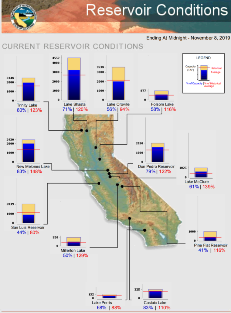
Most major California reservoirs are above their historical averages as of November 8, 2019. (Graphic: California DWR)
Water Year 2020 begins with robust reservoir storage
The 2019 water year (October 1 – September 30) pushed snowpack levels well-above average and swelled major reservoirs to above-average. There were more than 30 atmospheric rivers, with many making landfall in Northern California. The state’s snowpack on April 1 was 175% of average.
The California Department of Water Resources said that makes a great start to 2020.
“We start the new water year in a good place,” said Karla Nemeth, director of the DWR. “However, we all know too well that California’s weather and precipitation are highly variable. What we have today could be gone tomorrow.”
Above average rainfall in San Diego
While the biggest gains in precipitation over the past year were in Northern California, the San Diego region also benefited. Water Year 2019 ended with the region at 125% of average rainfall at Lindbergh Field. The rainfall helped increase supplies in regional reservoirs.
Schnell cautioned that the climatological cycle in California can bring several consecutive years of drought, like the 2015-17 period, which prompted mandatory water-use reductions statewide.
Above-average temperatures in California in 2019
NOAA reported on November 6 that California experienced above-average to much-above-average temperatures from January through October 2019. The average U.S. temperature during that same period was 55.5°F, (0.5 of a degree above 20th-century average) “ranking in the warmest third of the record,” according to NOAA.
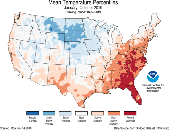
NOAA reported that California has had above-to much-above-average temperatures from January to October 2019. (Graphic: NOAA)
Scripps Institution of Oceanography’s Center for Western Weather and Water Extremes, or CW3E, just released an analysis that calculated the odds of water year 2020 reaching 100% of water year normal precipitation totals. The odds range from 20 to 40% of the Southwest reaching 100% of water year normal precipitation.
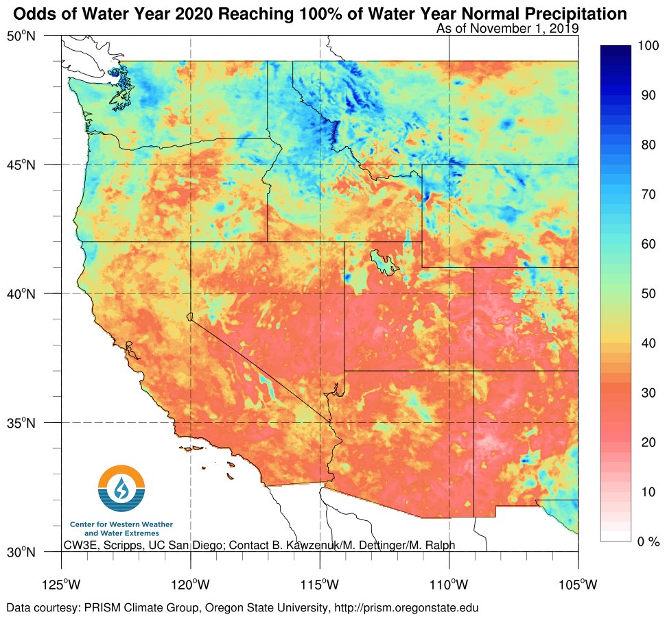
Odds of reaching normal precipitation for Water Year 2020. (Graphic: CW3E, Scripps, UC San Diego)
National Weather Service seasonal outlook for precipitation
The three-month seasonal precipitation outlook for November-December-January by the National Weather Service Climate Prediction Center shows below-normal to normal precipitation in Central to Northern California and equal chances of below, near- or above-normal in southern California and much of the Southwest.
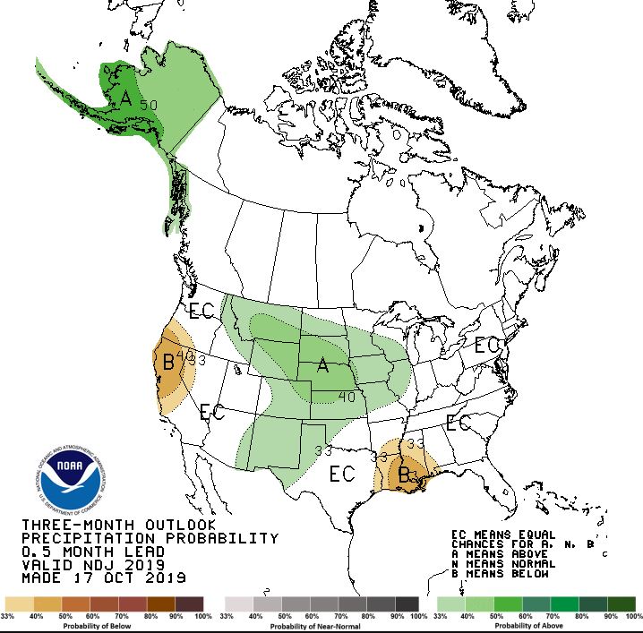
The November-December-January precipitation outlook from the National Weather Service. (Graphic: NWS/NOAA)
“There will always be fluctuations based on weather and other factors, but the San Diego region continues to embrace water-use efficiency,” said Schnell. “The Water Authority and its 24 member agencies continue to increase San Diego County’s water supply reliability through supply diversification to provide a safe, reliable water supply to the region.”