Posts

Opinion: California Must Modernize its Water System to Avoid Extremes of Drought to Flood

Most of California exists under dueling states of emergency. Since February, storms have caused emergency-level flooding and damage in 47 of the state’s 58 counties, yet most of California only recently exited a drought emergency.

One rainy season can’t supplant years of drought, but images of flooded cities and towns — and the injuries and deaths caused by these disasters — are made more painful when we hear that our state is running out of water nevertheless. The question that water managers and state policymakers must address is how to adapt our water system to eliminate the dual states of emergency.

After 14 Atmospheric Rivers, How Full Are California’s Reservoirs?

As wet weather has continued to impact California, some reservoirs across the state are being managed with scheduled releases of water to prevent flooding, according to the California Department of Water Resources.

After 14 atmospheric rivers hit back-to-back this winter, reservoirs began filling quickly. Though most of the major reservoirs aren’t full yet, several are significantly higher than they have been historically. This is especially true in Central California at the Don Pedro, Camanche and Oroville reservoirs, KTLA sister station KRON reports.

January Storms Leave L.A. County Flood-Control Dams at Risk of Overflowing

Now that the shock of a series of January storms has worn off, Los Angeles County officials face a herculean chore: Five reservoirs along south-facing San Gabriel Mountain slopes are filled with so much debris and soupy mud that they pose a flood risk to the communities below.

Opinion: Feds Should Focus on Natural Solutions in Flood Preparation

Our country faces a flood crisis. More people and places are at risk, with climate-induced flooding threatening widespread social, environmental and economic impacts.

We need a holistic approach to reduce flood risk now. The U.S. Army Corps of Engineers has focused on building levees, spillways and hardened infrastructure to address episodic storm events. But, by focusing solely on storm surge, they leave millions exposed to chronic flooding from sea level rise, tides and extreme rainfall.

Corps of Engineers Considers Nature-Based Flood Control

The U.S. Army Corps of Engineers is known for damming rivers and building levees to keep waterways at bay. But a new initiative seeks natural flood control solutions as climate change brings increasingly frequent and severe weather events that test the limits of concrete and steel.

It only makes sense to use Mother Nature’s flood defenses as one of the tools to combat destruction from intense rains in the middle of the country and storms and sea level rise on the coasts, says Todd Bridges, who heads the Corps Engineering with Nature initiative.

Water Resilience Projects Receive Nearly $84 Million from DWR

The California Department of Water Resources has announced the latest funding awards for several water resilience projects throughout the state. A total of $83.9 million grant funding has been issued to communities in San Diego, San Joaquin, Sacramento, Sierra and Central Coast regions. The funding is aimed at supporting projects to address infrastructure needs, depleted groundwater levels, flood control issues, and other water issues of critical importance.

Most Major California Dams Lack Emergency Plans. ‘High-Risk Issue,’ State Auditor Says

The vast majority of California’s major dams aren’t adequately prepared for an emergency.

Three years after the near-disaster at Oroville Dam, only 22 state-regulated dams have finalized emergency plans — out of 650 major dams that are required by law to have plans in place — according to a report issued Thursday by State Auditor Elaine Howle.

City of San Diego May Release Water from Lake Hodges in Coming Months

The city of San Diego may release water from Lake Hodges reservoir into San Dieguito River in coming months if heavy rain raises the water level above the maximum permitted.

For safety reasons, the California Division of Safety of Dams has determined that the water level should not be above 295 feet, which is 20 feet below the spillway elevation. If the water nears that level when rain is forecast, city officials will likely open valves at the dam for a controlled release of some of the water. The released water will enter San Dieguito River and eventually the Pacific Ocean.

Can a New Approach to Managing California Reservoirs Save Water and Still Protect Against Floods?

Many of California’s watersheds are notoriously flashy – swerving from below-average flows to jarring flood conditions in quick order. The state needs all the water it can get from storms, but current flood management guidelines require reservoirs to dump water each winter to make space for flood flows that may not come. However, new tools and operating methods could lead the way to a redefined system that improves both water supply and flood protection capabilities.

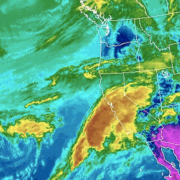
GOES satellite image of the atmospheric river phenomena from March 20, 2018.

California Funds Atmospheric Rivers Research

A better understanding and forecasting of atmospheric rivers could improve flood control and water management in California.

The 2019-20 California state budget includes $9.25 million to pay for research into how the state Department of Water Resources can more accurately track the intensity and landfall locations of atmospheric rivers. About half of the state’s annual rainfall and 90 percent of its flooding come from such events.

“Improved forecasting and monitoring of atmospheric river storms would benefit not only California, but the Southwest, in managing our water supply,” said Kelley Gage, director of water resources for the San Diego County Water Authority. “With better forecasting, water managers could also prepare and plan for flooding events caused by the atmospheric rivers.”
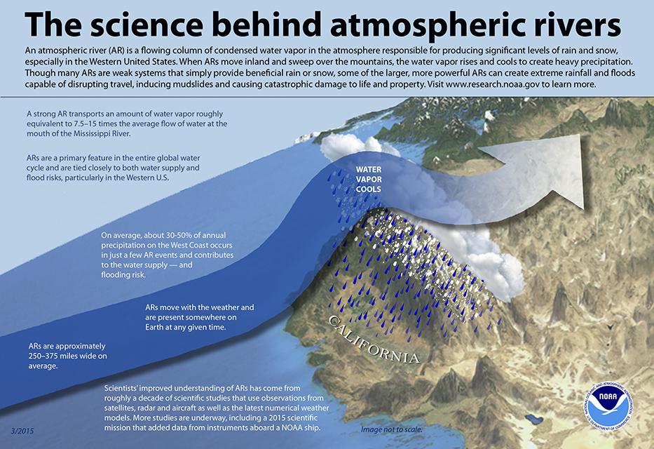
The science behind atmospheric rivers

The science behind atmospheric rivers. Graphic: NOAA

Rivers in the sky

Atmospheric rivers are relatively long, narrow regions in the atmosphere – like rivers in the sky – that transport most of the water vapor outside of the tropics, according to NOAA. When the atmospheric rivers make landfall, they release the water vapor in the form or rain or snow.

“The rivers can stretch from 250 to 370 miles wide and carry a water amount more than 7 times the volume of the Mississippi River,” said Alexi Schnell, water resources specialist with the Water Authority.

The research funds were allocated to the Department of Water Resources to “improve observations, forecasts and decisions in support of atmospheric river precipitation events” as part of the DWR’s Research, Mitigation, and Climate Forecasting Program.

Atmospheric Rivers

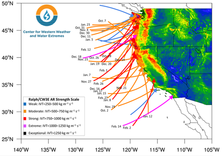
Atmospheric Rivers in Water Year 2019. Graphic: Center for Western Weather and Water Extremes

Volatile water resources

A new study led by Scripps Institution of Oceanography at UC San Diego suggests that a new regime of wet and dry extremes is emerging in California. The study shows that the projected increase of extreme precipitation is likely to be caused by streams of moisture in the sky known as atmospheric rivers.

The study was published July 9 in the journal Nature Scientific Reports.

“California already has the most volatile water resources in the country,” according to a news release from Scripps. “Scripps scientists discovered that the state’s precipitation, as it becomes less frequent but preferentially stronger, will vacillate even more wildly between extremes of drought and flooding as a consequence of climate change.”

The federal Bureau of Reclamation, the Southwest Climate Adaptation Science Center, NOAA, the U.S. Geological Survey, and NASA funded the study, “Precipitation regime change in Western North America: The role of Atmospheric Rivers.”

California weather extremes

“As Mediterranean climate regions around the world are becoming more subtropical, the dry season is expanding. California is no exception,” said Alexander Gershunov, a climate scientist at Scripps. “What is exceptional about California is that the heavy precipitation is projected to become more extreme. We knew this from our past work. Now we have identified the mechanism responsible for this bolstering of extremes, and that gives us a more nuanced understanding of what to expect from future hydroclimate and a clearer interpretation of ongoing changes.”
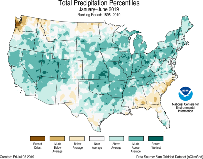
 

Atmospheric Rivers helped California's snowpack in Winter 2018-19.

For the year-to-date 2019, the precipitation total was 19.05 inches, 3.74 inches above average, and the wettest such period in the 125-year record. Graphic: NOAA

Atmospheric Rivers boost snowpack

During the 2018-19 winter, atmospheric river events significantly increased snowpack in the Sierra Nevada and the Rocky Mountains. Both areas are key sources of water supply for the Southwest, including California and San Diego County.

Precipitation in the contiguous U.S. was above average from January to June 2019, according to a NOAA climate report released this week. The report said the 19.05 inches during the six-month period was 3.74 inches above average and the wettest such period in the 125-year record.

The January-to-June 2019 precipitation map showed California’s statewide precipitation was “above average” and “much above average.”