Posts

The West’s Winter Is Off To A Dry Start, Raising Concerns For The Nation’s Largest Reservoirs

Even as winter arrived in the East this week, with treacherous snow and an impending Arctic cold snap, much of the West and its major river basins are still entrenched in warm and dry conditions. It’s a sluggish start to what should be the region’s wet season and is raising concerns about the future of the water supplies that depend on it.

Why a Triple-Dip La Niña Could Be Bad News for California

A rare triple-dip La Niña is looking increasingly likely for the Northern Hemisphere. The latest outlook by NOAA’s Climate Prediction Center, released Thursday, indicates there’s a 62% to 66% chance the current La Niña climate condition will persist through fall and early winter.

If that happens, it’ll be the third La Niña winter in a row – a rare phenomenon we’ve only seen twice since 1950. A third consecutive La Niña year would likely have a major impact on California.

February Could Be the Make-Or-Break Month for California’s Drought

California is nearing that make-or-break point to pick up some rain and snow totals. January has turned out to be a total bust for big storms, continuing that winter whiplash of wet to dry weather.

Almost all the gains we’ve made reducing the severity of our two-year drought came from storms in October and December. In October, those gains were from one big atmospheric river sitting over the state for days. December saw multiple storms ending in a record setting snowiest month for the Sierra.

Why This Viral Map Isn’t the Best Indicator of California Drought

With a parade of storms sweeping California in December, the federal government’s US Drought map has shown severe drought conditions fade across the state in recent weeks, and on the most recent map released Thursday, “exceptional drought” — the most extreme level of drought — completely disappeared from the map.

The map quickly went viral on Reddit, but Jeanine Jones, the drought manager for the California Department of Water Resources, cautioned that the map isn’t an accurate depiction of the overall picture in the state and said that the drought is far from over.

Satellite Images Show Mount Shasta’s Transformation After an Exceptionally Dry Summer

After one of its driest summers in years, satellite images show that Mount Shasta is blanketed in its signature snow once again after December storms swept across Northern California.

The images show the mountain nearly entirely devoid of snow in early September, after a very hot summer for the region compounded the lack of snowpack after two severely dry winters, dissipating the snowpack earlier than normal. Just four months later, the mountain appeared transformed, covered in snow once again.

La Niña: Is California Heading Into Another Dry Winter?

You may have seen it on social media or heard it while talking to a friend: This is a La Niña year, so California won’t get any rain this winter and the severe drought is only going to get worse. Right?

Maybe not. Although that’s a common belief, it’s not supported by past history. The reality is that a lot depends on where you live.


California’s Unusually Dry Winter Could be the New Normal, According to Decades of Data

As Californians can tell by the already beige hills, the early fire weather warnings and the dusty umbrellas sitting deep inside closets, it’s been drier than usual this winter.

And according to decades worth of precipitation data, that’s the new normal.

Water Shortages and Fires Loom After a Dry Winter

Good morning.

The weather forecast today calls for sunshine across the state, with barely a cloud on the horizon for the next week or so.

Pour yourself a nice, cool glass of water — and then think about how you’re going to start conserving it.

The lack of rain and snow during what is usually California’s wet season has shrunk the state’s water supply. The Sierra Nevada snowpack, a crucial source of water as it melts over the spring and summer, is currently at 65 percent of normal. Major reservoirs are also low.

Anza-Borrego Desert Research Center-Sicco Rood-March-2020-WNN water supply

Water Supply Diversification Overcomes Dry Winter

No ‘March Miracle’ for snow and rain in California, but the San Diego County Water Authority has diversified water supply sources to weather the boom-and-bust cycle of California winters.

March brought abundant precipitation throughout California, but not enough to offset a dry February. Most large urban water agencies in the state maintain a reliable water supply in wet and dry years.

“California’s climate variability is why a water resilience portfolio is needed to provide a safe and plentiful water supply,” said Goldy Herbon, Water Authority senior water resources specialist. “Whether a wet or dry year, the Water Authority and its 24 member agencies have successfully diversified water sources to ensure a reliable supply to meet the needs of the region’s 3.3 million people.”

The supply sources include water from the Claude “Bud” Lewis Carlsbad Desalination Plant, where ten workers volunteered to live on-site to keep the water flowing during the coronavirus pandemic.

Lindbergh Field has received 9.76 inches of rain – or 108% of normal – from October 1, 2019 – April 2, 2020. Many areas in the San Diego region received snow in March, including the Anza-Borrego Desert State Park.

Even with a lackluster winter, the state’s six largest reservoirs hold between 82% and 125% of their historical averages for April 1, according to the California Department of Water Resources. Lake Shasta is 98% of its historical average and is at 79% of capacity.
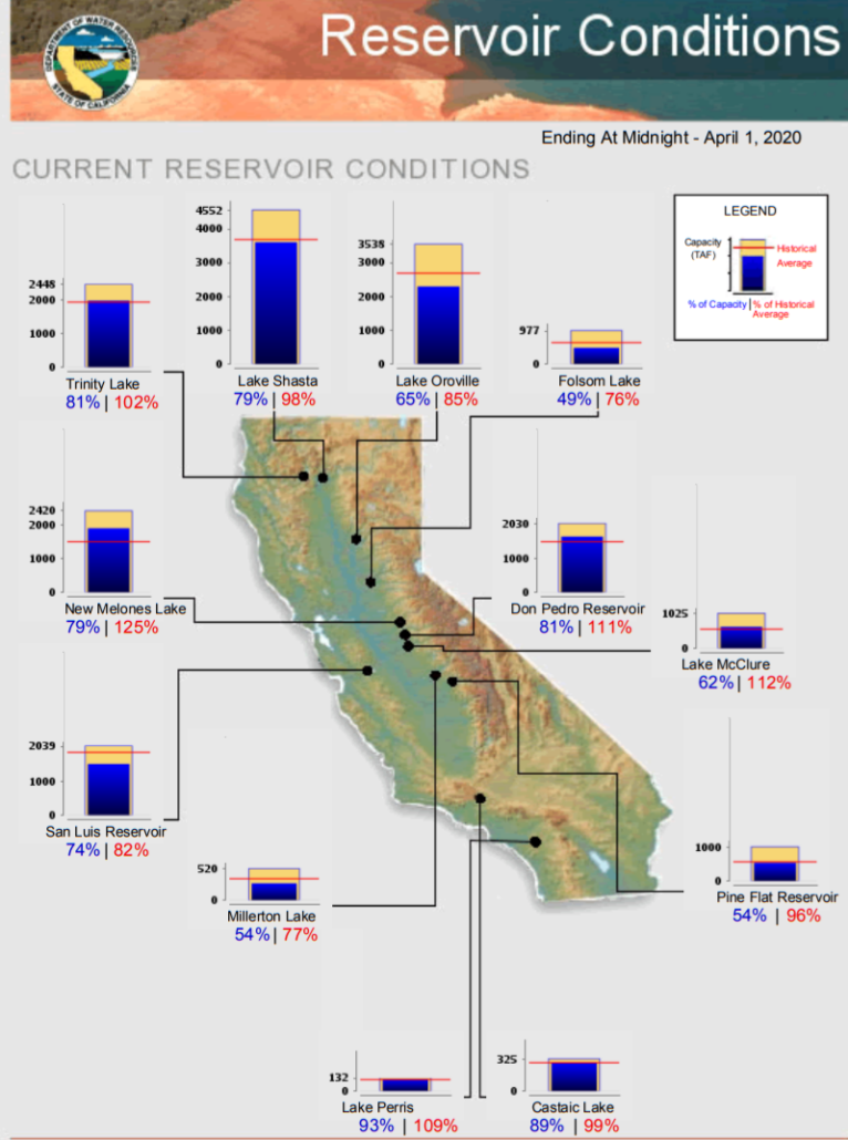
Major California Reservoirs-April 1 2020-WNN-CA DWR graphic

The Department of Water Resources April 1 conducted the fourth manual snow survey of 2020 at Phillips Station near Lake Tahoe. The manual survey recorded 43.5 inches of snow depth and a snow water equivalent (SWE) of 16.5 inches, which is 66% of the April average for this location.

The SWE measures the amount of water contained in the snowpack, which provides a more accurate forecast of spring runoff. Measurements from the 130 electronic snow sensors, scattered throughout the state, indicate that the statewide snowpack’s water equivalent is 15.2 inches, or 53% of the April average.
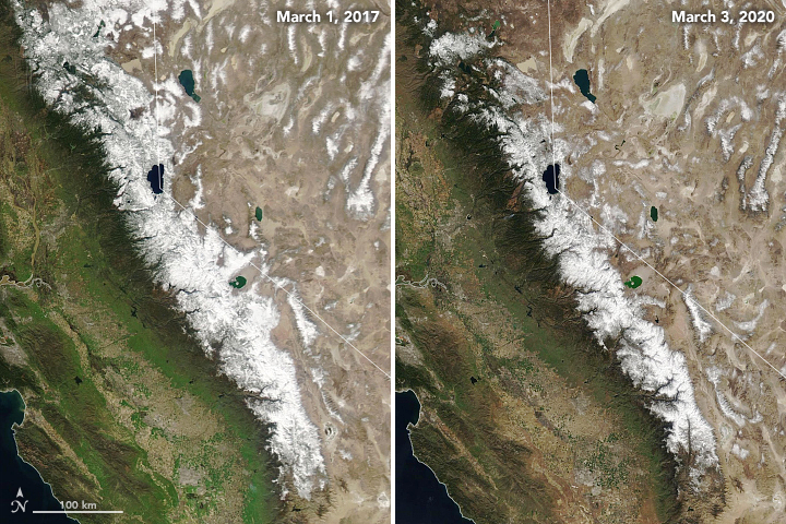
Sierra Nevada Snowpack Comparison-NASA satellite image-WNN-April 2020

The natural-color satellite images above, acquired by the Moderate Resolution Imaging Spectroradiometer (MODIS) instruments on NASA’s Terra and Aqua satellites, show the area covered by snow in March 2020 compared to March 2017 (a record high year). Graphic: NASA/NASA JPL

“While today’s survey results show our snowpack is better off than it was just last month, they still underscore the need for widespread, wise use of our water supplies,” said DWR Director Karla Nemeth. “California’s climate continues to show extreme unpredictability, and February’s record dryness is a clear example of the extremes associated with climate change.”

On average, the snowpack supplies about 30% of California’s water needs as it melts in the spring and early summer, the state agency reported in news release.

New Water Year Brings Uncertainty

Monday marked the beginning of the 2019 water year. Experts say it’s hard to know what this year will bring – considering the state’s significant weather variability on a year-to-year basis – but steps are being taken to prepare in spite of the uncertainty. “It’s been relatively dry so far this past water year, but it’s no indication of what kind of year we are going to have in Water Year 2018-19,” said Mike Inamine, executive director of the Sutter Butte Flood Control Agency.