Atmospheric rivers can wreak havoc on the West Coast. These “rivers in the sky” stream enormous amounts of moisture from the tropics to western North America — double the flow of the Amazon River, on average. This moisture can produce downpours that cause widespread flood damage. From 1978 to 2017, this damage amounted to $1.1 billion per year according to a 2022 study. But atmospheric rivers are also crucial for life in California.
An expanded Atmospheric River Reconnaissance program began last month as a result of the unexpected “bomb cyclone” in October 2021 that hit North America’s West Coast, followed by another atmospheric river less than a month later that caused severe flooding in Washington.
“Climatologically, November and December can bring some of the worst floods for that part of the world,” said research meteorologist Marty Ralph, director of the Center for Western Weather and Water Extremes (CW3E) at UC San Diego’s Scripps Institution of Oceanography. Ralph leads the AR Recon program, along with Vijay Tallapragada, Ph.D., Senior Scientist at NOAA’s Environmental Modeling Center, in partnership with the U.S. Army Corps of Engineers, the California Dept. of Water Resources, NOAA Office of Marine and Aviation Operations, and the U.S. Air Force Reserve 53rd Weather Reconnaissance Squadron “Hurricane Hunters.”
https://www.waternewsnetwork.com/wp-content/uploads/2024/04/WNN-Horizontal-White-Blue2.png00Mike Leehttps://www.waternewsnetwork.com/wp-content/uploads/2024/04/WNN-Horizontal-White-Blue2.pngMike Lee2022-12-07 10:21:562022-12-07 14:36:22Atmospheric River Reconnaissance Flight Season Gets an Early Start This Winter
Two atmospheric rivers (ARs) are forecast to make landfall along the US West Coast on 9 Dec and 12 Dec. The first AR is forecast to bring a short period of AR 1 conditions (based on the Ralph et al. 2019 AR Scale) to coastal Southern Oregon. The deterministic GFS and ECMWF have drastically different solutions for a developing area of low-pressure associated with the second AR, making it difficult to pinpoint the timing, IVT intensity, and landfall location.
https://www.waternewsnetwork.com/wp-content/uploads/2024/04/WNN-Horizontal-White-Blue2.png00Mike Leehttps://www.waternewsnetwork.com/wp-content/uploads/2024/04/WNN-Horizontal-White-Blue2.pngMike Lee2022-12-06 10:54:542022-12-06 10:56:46Potential for Multiple Atmospheric Rivers to Impact the US West Coast During the Next 7 Days
A team led by Kristen Guirguis, a climate researcher at Scripps Institution of Oceanography at UC San Diego, found evidence that the risk of hazardous weather is increasing in the Southwest.
The researchers investigated the daily relationships among four major modes of weather affecting California. How they interact governs the formation of weather events such as atmospheric rivers capable of bringing torrential rains and Santa Ana winds that can spread devastating wildfires.
“This study suggests that weather patterns are changing in a way that enhances hot, dry Santa Ana winds, while reducing precipitation frequency in the Southwest,” said Guirguis. “These changes in atmospheric circulation are raising the risk of wildfires during California winters.”
Dillard Road is flooded near the Hwy 99 off ramp, located south of Elk Grove, California. Photo credit: Florence Low / California Department of Water Resources.
The basis of the research was an examination of the dominant atmospheric circulation patterns over the North Pacific Ocean, known as Baja-Pacific, Alaskan-Pacific, Canadian-Pacific, and Offshore-California modes. What distinguishes them from each other are the relative positions of ridges and troughs in the atmosphere.
Weather patterns and a warmer atmosphere
The research team identified 16 recurring weather patterns that are created daily as these modes interact with each other. One product of the work was a summary of California weather patterns from 1949 to 2017. The patterns associated with the formation of dry gusty Santa Ana winds that often stoke Southern California fires are becoming more frequent. Patterns associated with what might be considered “normal” rainfall are decreasing in the Southwest thus promoting drought, but patterns associated with extreme precipitation and strong atmospheric river episodes have remained steady over the study period. The researchers noted that while the patterns associated with heavy precipitation and strong atmospheric rivers have not changed in frequency, a warmer atmosphere is capable of holding more water so these storms are becoming more damaging.
Challenges for wildfire and water resource management
The results suggest an increasing probability of compounding environmental hazards during California winters, said the research team. Though winter atmospheric rivers are the antithesis of hot, dry Santa Ana wind conditions, sequences of wildfires followed by strong atmospheric rivers often compound the damage from fires when they trigger flash floods and destructive debris flows from burn scars.
Photo of the Thomas Fire taken from a Santa Barbara beach. Photo credit: Carsten Schertzer / iStock.
“This spells challenges for wildfire and water resource management and provides observational support to our previous results projecting that California will increasingly have to depend on potentially hazardous atmospheric rivers and floodwater for water resource generation in a warming climate,” said study co-author Alexander Gershunov, a Scripps Oceanography climate scientist.
Study authors say this work is helping to inform an experimental subseasonal-to-seasonal (S2S) forecast product being developed at Scripps Oceanography’s Center for Western Weather and Water Extremes (CW3E) that predicts extreme weather in California including atmospheric river landfalls, Santa Ana winds, drought, and heat waves.
The U.S. Department of the Interior via the Bureau of Reclamation and the Southwest Climate Adaptation Science Center, the California Department of Water Resources, and the Regional Integrated Sciences and Assessments (RISA) California—Nevada Climate Applications Program and the International Research Applications Program of the National Oceanic and Atmospheric Administration funded the study. Additional funding was provided by the University of California Office of the President MRPI grant.
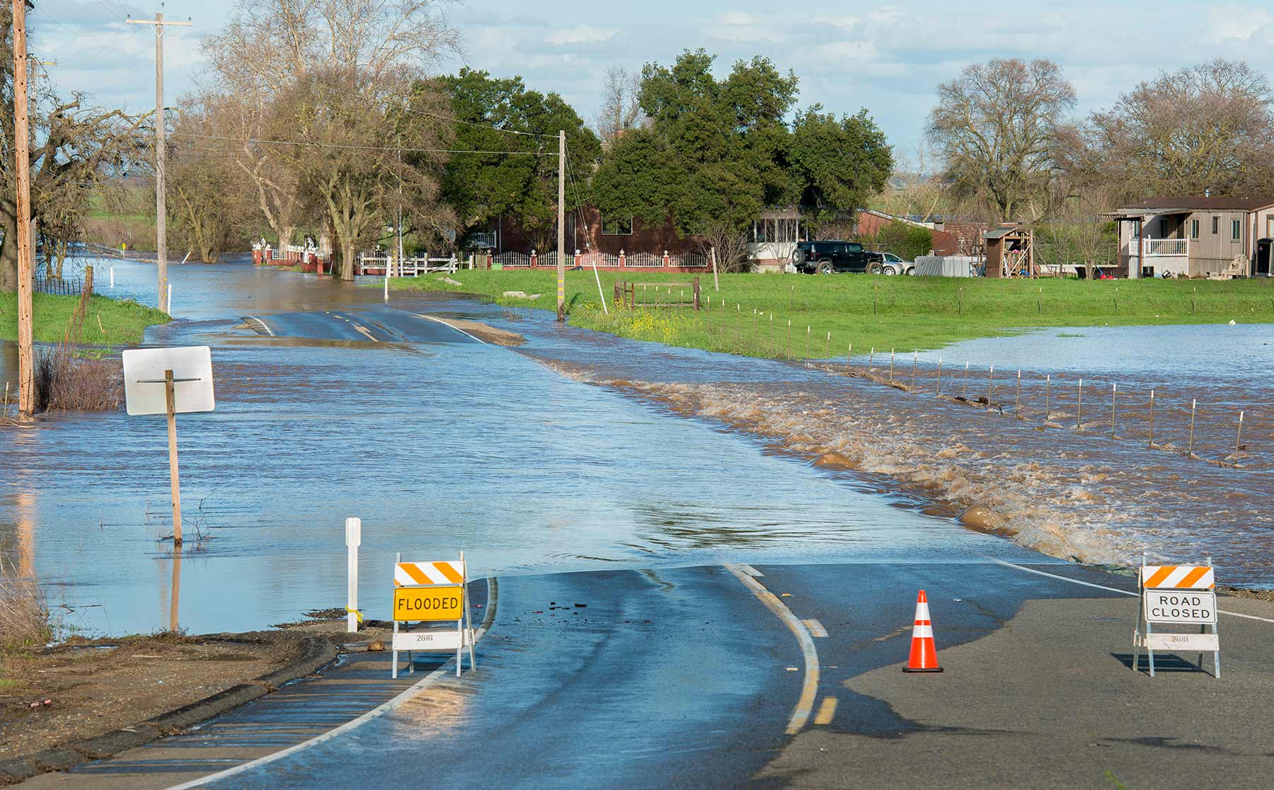
High water levels on the Tuolumne River close River Road in the city of Modesto, California, part of Stanislaus County. Photo credit: Dale Kolke / California Department of Water Resources.
The San Diego County Water Authority has a partnership with the Scripps Institution of Oceanography at UC San Diego to better predict atmospheric rivers and improve water management before, during and after seasonal storms.
(Editors Note: Study co-authors include Benjamin Hatchett of the Desert Research Institute in Nevada; Tamara Shulgina, Michael DeFlorio, Rosana Aguilera, achel Clemesha, Tom Corringham, Luca Delle Monache, and Marty Ralph of CW3E at Scripps Oceanography; Aneesh Subramanian and David Reynolds of the University of Colorado Boulder; Janin Guzman-Morales of the University of California Santa Barbara; and Alex Tardy and Ivory Small of the National Weather Service.)
https://www.waternewsnetwork.com/wp-content/uploads/2022/08/Flooding-primary-photo-UCSD-study.jpg450845Mike Leehttps://www.waternewsnetwork.com/wp-content/uploads/2024/04/WNN-Horizontal-White-Blue2.pngMike Lee2022-08-12 13:16:102022-08-12 13:16:10More Evidence that California Weather is Trending Toward Extremes
A team led by Kristen Guirguis, a climate researcher at Scripps Institution of Oceanography at UC San Diego, found evidence that the risk of hazardous weather is increasing in the Southwest.
The researchers investigated the daily relationships among four major modes of weather affecting California. How they interact governs the formation of weather events such as atmospheric rivers capable of bringing torrential rains and Santa Ana winds that can spread devastating wildfires.
https://www.waternewsnetwork.com/wp-content/uploads/2024/04/WNN-Horizontal-White-Blue2.png00Mike Leehttps://www.waternewsnetwork.com/wp-content/uploads/2024/04/WNN-Horizontal-White-Blue2.pngMike Lee2022-08-11 09:57:152022-08-11 10:01:39More Evidence That California Weather is Trending Toward Extremes
California as a whole continues to be in its third year of drought, but earlier in the water year, it had a strong chance to see a normal water year. After a strong atmospheric river arrived in October, the first month of the 2021-2022 water year. Forecast models from the Center for Western Weather and Water Extremes, showed the Sacramento region as having about an 80% chance of meeting an average water year.
https://www.waternewsnetwork.com/wp-content/uploads/2024/04/WNN-Horizontal-White-Blue2.png00Mike Leehttps://www.waternewsnetwork.com/wp-content/uploads/2024/04/WNN-Horizontal-White-Blue2.pngMike Lee2022-07-15 10:19:042022-07-15 10:27:07How Much Rainfall Has Sacramento Actually Got This Year?
While the state of California is in its third year of drought, the Sacramento City Council has approved the sale of up to $5 million worth of water from the Sacramento and American Rivers.
Carlos Eliason, spokesperson for the City of Sacramento Department of Utilities, said there is about 16,500 acre feet of surface water on our rivers. The city council approved to drop the 10,000 acre feet of input, or about 3.26 billion gallons of water, and divert it to state contractors and the Santa Clara Valley Water District.
https://www.waternewsnetwork.com/wp-content/uploads/2024/04/WNN-Horizontal-White-Blue2.png00Mike Leehttps://www.waternewsnetwork.com/wp-content/uploads/2024/04/WNN-Horizontal-White-Blue2.pngMike Lee2022-06-03 10:05:372022-06-03 13:27:51Sacramento City Council Approves Water Sale for Up to $5 Million
Dry heat is already being felt at the beginning of May, and without rain, the drought continues across all of California.
Experts said California is in its third consecutive year of drought.
This week, some of the top water experts in the state were in Sacramento to think of solutions. Experts talked about the ongoing dry hydrology – the idea that this dry climate will be consistent up and down the state for the foreseeable future.
https://www.waternewsnetwork.com/wp-content/uploads/2024/04/WNN-Horizontal-White-Blue2.png00Mike Leehttps://www.waternewsnetwork.com/wp-content/uploads/2024/04/WNN-Horizontal-White-Blue2.pngMike Lee2022-05-05 10:19:562022-05-05 10:21:31Dozens of Water Agencies Meet to Discuss Drought
Few landfalling atmospheric rivers in the current water year have reached California, now in the third year of a statewide drought.
The latest update from the Center for Western Weather and Water Extremes, Scripps Institution of Oceanography at UC San Diego, shows that Water Year 2022 started strong in October, but weaker storms did not ease dry conditions.
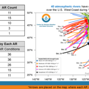
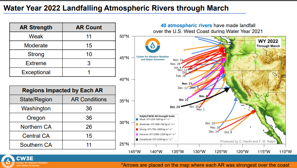
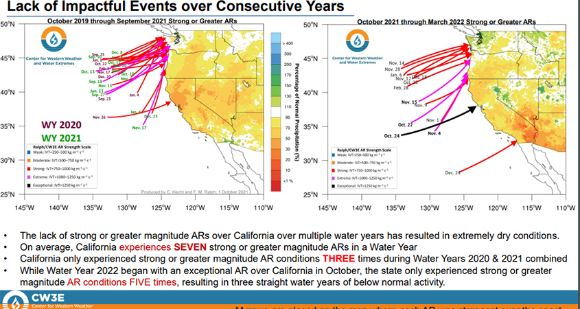
Landfalling atmospheric rivers
The CW3E report, Distribution of Landfalling Atmospheric Rivers over the U.S. West Coast During Water Year 2022: Summary Through March, was published April 7.
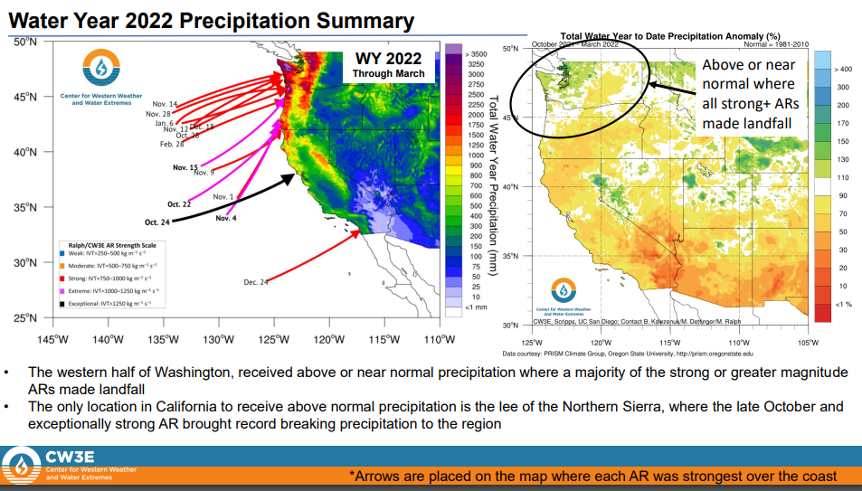
“While Water Year 2022 began with an exceptional AR over California in October, the state only experienced strong or greater magnitude AR conditions FIVE times, resulting in three straight water years of below normal activity,” according the report.
The report shows that the “lack of impactful events over consecutive years” – water year 2021 and water year 2020, combined with the current water year, has resulted in three straight years of below normal activity. Bottom line: If California hoped strong atmospheric rivers would end the current drought this water year, that’s not happening, at least so far. And the two previous years were a bust, creating extremely dry conditions across the state.
CW3E and Water Authority partnership
The San Diego County Water Authority partnered with the Scripps Institution of Oceanography, Center for Western Weather and Water Extremes, at UC San Diego in 2020 to better predict atmospheric rivers and improve water management before, during, and after those seasonal storms. The Center and its partners share best practices in forecast-informed reservoir operations, increased research around atmospheric rivers and droughts, and develop strategies for mitigating flood risk and increasing water supply reliability.
“Through our partnership with CW3E and the AR forecasting tools they’ve developed, it better prepares us in management of our water resources using regional storage,” said Jeff Stephenson, Water Resources Manager with the San Diego County Water Authority, in 2021. “This storage, in conjunction with developing multiple water supply sources in the San Diego region, has prepared us for years when rainfall levels are below normal in the region.”

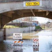
 Dillard Road is flooded near the Hwy 99 off ramp, located south of Elk Grove, California. Photo credit: Florence Low / California Department of Water Resources.
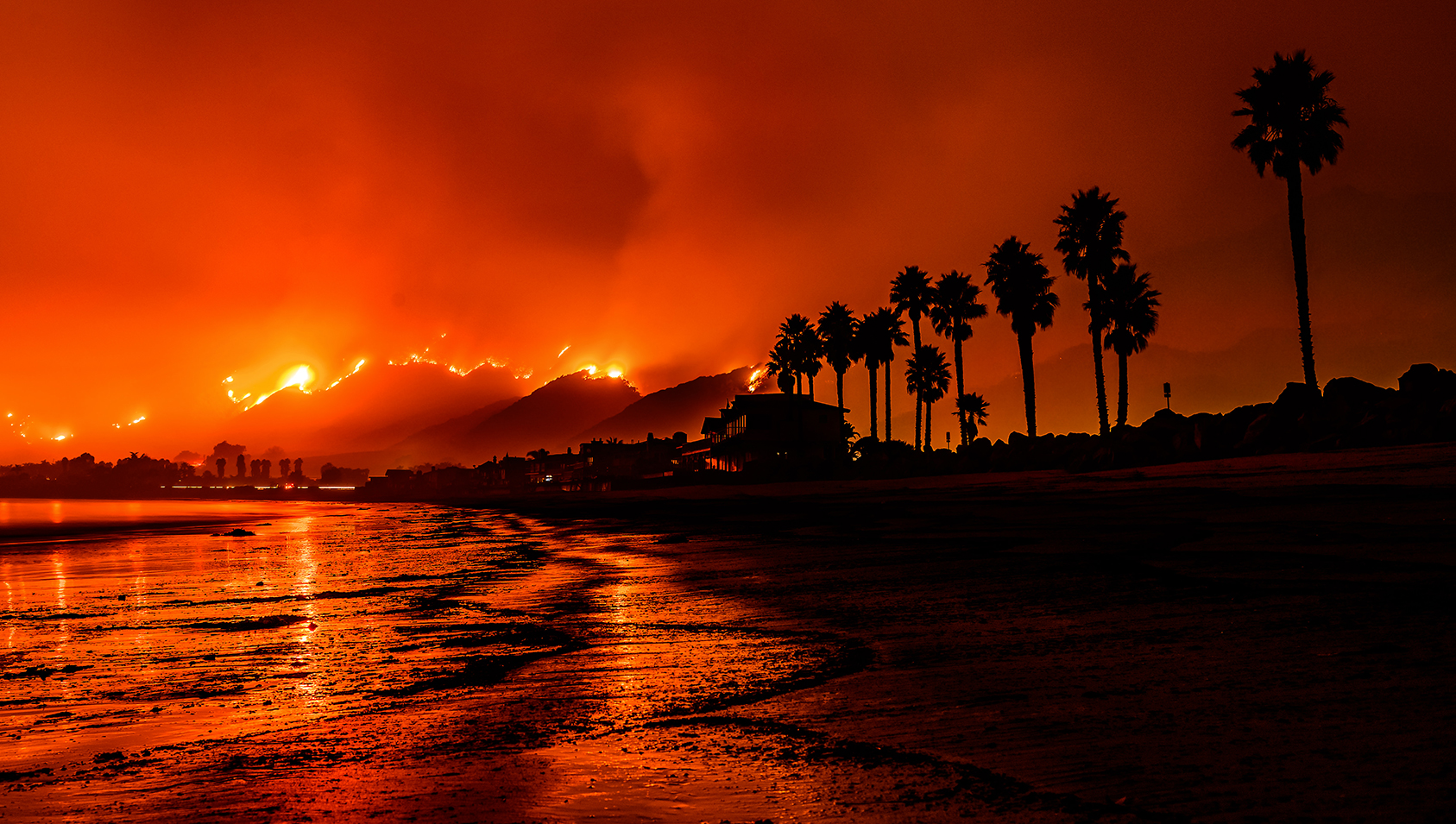 Photo of the Thomas Fire taken from a Santa Barbara beach. Photo credit: Carsten Schertzer / iStock.
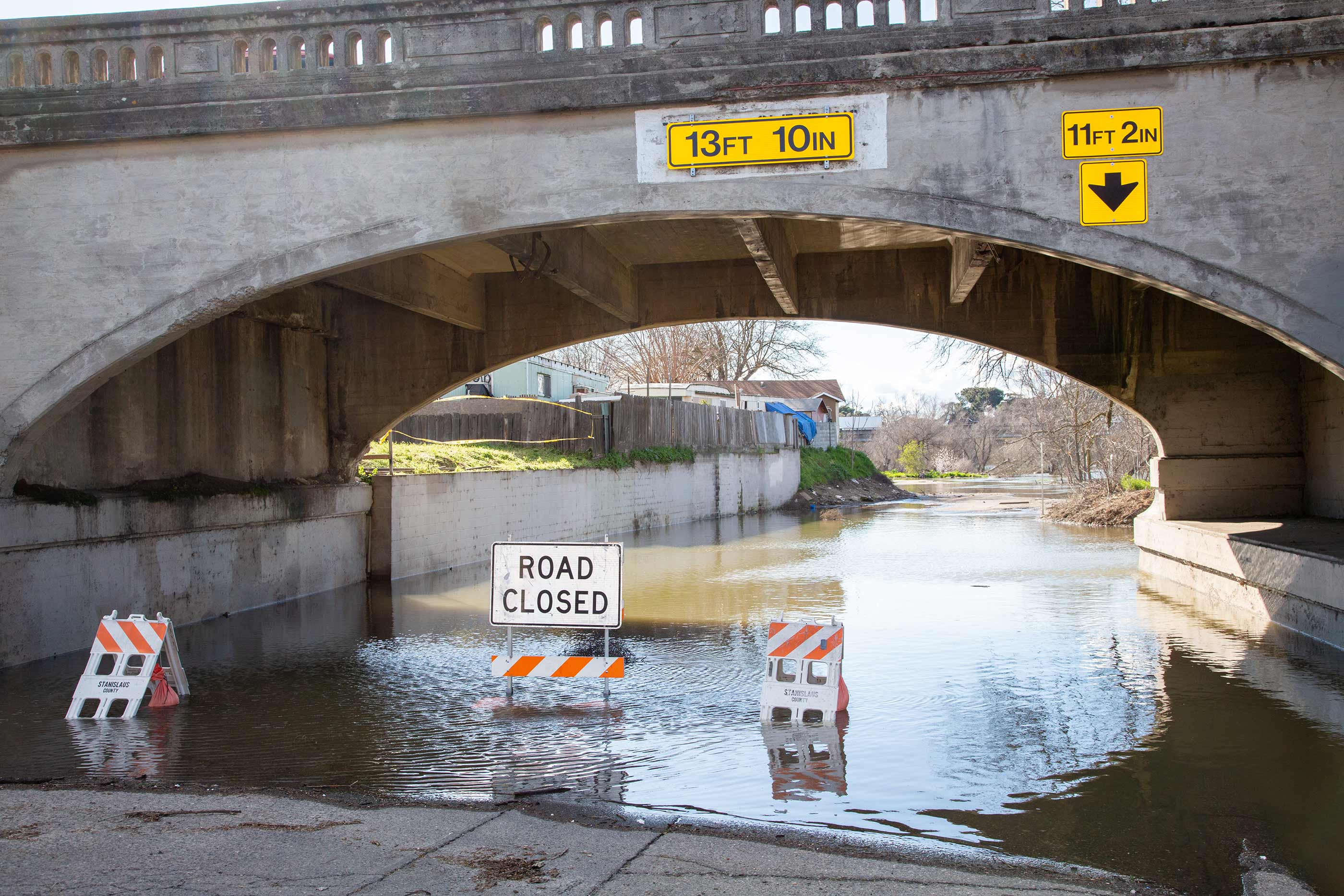 High water levels on the Tuolumne River close River Road in the city of Modesto, California, part of Stanislaus County. Photo credit: Dale Kolke / California Department of Water Resources.