Tag Archive for: Atmospheric Rivers

FIRO-Scripps-Law-Water Management

New California Law Taps Science to Improve Water Management

Legislation signed into law by California Governor Gavin Newsom ensures the state has the science and weather forecasting tools it needs for more flexible reservoir operations. The bill, AB 30, makes breakthrough water management technology standard for the California Department of Water Resources.

The legislation was introduced by San Diego Assemblymember Chris Ward and co-sponsored by the Sonoma County Water Agency and the San Diego County Water Authority. The bill was supported by the Water Authority’s partner, UC San Diego’s Scripps Institution of Oceanography.

The strategy is called forecast-informed reservoir operations, or FIRO, and it complements Gov. Newsom’s California Water Supply strategy released in August 2022 calling for more reservoir storage capacity to capture runoff from big storms, often fueled by atmospheric rivers. The governor and Legislature have already provided funding for state water managers to integrate the strategy.

FIRO-Science-water management

Diagram illustrating the FIRO process to develop an adaptive water control manual. Graphic courtesy Scripps Institution of Oceanography Center for Western Weather and Water Extremes

FIRO-Scripps-Law-Water Management

New California Law Taps Science to Improve Water Management

Legislation signed into law by California Governor Gavin Newsom ensures the state has the science and weather forecasting tools it needs for more flexible reservoir operations. The bill, AB 30, makes breakthrough water management technology standard for the California Department of Water Resources.

The legislation was introduced by San Diego Assemblymember Chris Ward and co-sponsored by the Sonoma County Water Agency and the San Diego County Water Authority. The bill was supported by the Water Authority’s partner, UC San Diego’s Scripps Institution of Oceanography.

Forecast-Informed Reservoir Operations strategy will help deal with drought and flood

The strategy is called forecast-informed reservoir operations, or FIRO, and it complements Gov. Newsom’s California Water Supply strategy released in August 2022 calling for more reservoir storage capacity to capture runoff from big storms, often fueled by atmospheric rivers. The governor and Legislature have already provided funding for state water managers to integrate the strategy.

“We thank Assemblymember Chris Ward for his leadership and vision in supporting next-gen water management and flood reduction efforts that will benefit residents statewide,” said Mel Katz, chair of the San Diego County Water Authority Board of Directors. “The legislation provides an innovative approach to help San Diego County and California thrive in the changing climate.”

Forecast-informed reservoir operations use weather predictions to advise dam operators about how much water to retain or release from reservoirs, enhancing their ability to handle whatever nature serves up while retaining as much water as possible in storage.

FIRO-Science-water management

Diagram illustrating the FIRO process to develop an adaptive water control manual. Graphic courtesy Scripps Institution of Oceanography Center for Western Weather and Water Extremes

Many reservoirs in the West are strictly regulated based on historical averages of winter storms and spring runoff. Under existing rules, the highly variable rainfall from year to year is not directly considered. Complicating the problem, many current guidelines and practices were developed before satellites, radar and advanced numerical models significantly improved weather forecasts.

To address these challenges, researchers at Scripps Institution of Oceanography and elsewhere developed tools that provide weather forecasters with reliable notice of atmospheric rivers a week in advance. Advancing this research could have taken decades, but sophisticated prediction products have evolved in less than 10 years with funding by the San Diego County Water Authority and other water agencies statewide, along with state and federal support.

The Water Authority has partnered with SIO and the Scripps Center for Western Weather and Water Extremes at UC San Diego, to share and support best practices in FIRO, to increase research around atmospheric rivers and droughts, and develop strategies for mitigating flood risk and increasing water supply reliability.

San Diego County Water Authority And its 24 Member Agencies

New California Law Taps Science to Improve Water Management

Legislation signed into law by California Governor Gavin Newsom ensures the state has the science and weather forecasting tools it needs for more flexible reservoir operations. The bill, AB 30, makes breakthrough water management technology standard for the California Department of Water Resources.

The legislation was introduced by San Diego Assemblymember Chris Ward and co-sponsored by the Sonoma County Water Agency and the San Diego County Water Authority. The bill was supported by the Water Authority’s partner, UC San Diego’s Scripps Institution of Oceanography.

The strategy is called forecast-informed reservoir operations, or FIRO, and it complements Gov. Newsom’s California Water Supply strategy released in August 2022 calling for more reservoir storage capacity to capture runoff from big storms, often fueled by atmospheric rivers. The governor and Legislature have already provided funding for state water managers to integrate the strategy.

“We thank Assemblymember Chris Ward for his leadership and vision in supporting next-gen water management and flood reduction efforts that will benefit residents statewide,” said Mel Katz, chair of the San Diego County Water Authority Board of Directors. “The legislation provides an innovative approach to help San Diego County and California thrive in the changing climate.”

Forecast-informed reservoir operations use weather predictions to advise dam operators about how much water to retain or release from reservoirs, enhancing their ability to handle whatever nature serves up while retaining as much water as possible in storage.

Many reservoirs in the West are strictly regulated based on historical averages of winter storms and spring runoff. Under existing rules, the highly variable rainfall from year to year is not directly considered. Complicating the problem, many current guidelines and practices were developed before satellites, radar and advanced numerical models significantly improved weather forecasts.

To address these challenges, researchers at Scripps Institution of Oceanography and elsewhere developed tools that provide weather forecasters with reliable notice of atmospheric rivers a week in advance. Advancing this research could have taken decades, but sophisticated prediction products have evolved in less than 10 years with funding by the San Diego County Water Authority and other water agencies statewide, along with state and federal support.

The Water Authority has partnered with SIO and the Scripps Center for Western Weather and Water Extremes at UC San Diego, to share and support best practices in FIRO, to increase research around atmospheric rivers and droughts, and develop strategies for mitigating flood risk and increasing water supply reliability

drought relief-snowpack-West-NIDIS winter update

This Year’s Snow Season Wipes Away Drought in Much of the West

The 2022–2023 snow season started off relatively active across the West, with a few modest storms bringing snow accumulations to the mountains in early November.

By the start of December, snow water equivalent (SWE) across much of the region was above normal. Starting in early December, several storm cycles brought moisture-laden families of atmospheric rivers to the West Coast. Most of the landfalls occurred in California. The strongest series of storms occurred steadily from December 27 through January 17.

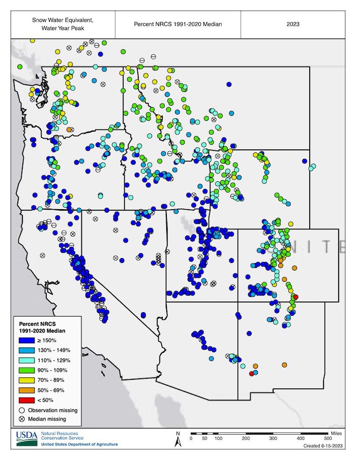
By the end of January, SNOTEL sites across much of the Sierra Nevada, Great Basin, Utah, Arizona, and western Colorado were at >150% of normal SWE. Unlike the 2021–2022 water year, in which snowfall was abundant early in winter but scarce after early January, the storm train continued with another series of strong storms across the West from late February through mid-March.

By April 1, snowpack was above normal across nearly the entire West, with few areas of snow drought. In some parts of the Sierra Nevada, Great Basin, Utah, Arizona, and western Colorado, SWE reached 200%–300% of normal and, in certain locations, set records. The northern Pacific Northwest and northwestern Montana was on the periphery of the storm track during most of winter. In these areas, snow drought developed as snowmelt began, and summer drought conditions are developing or seem likely to develop.

Key Points

  • An above-normal start to winter precipitation in the West—with the exception of the Pacific Northwest—accelerated when a series of 9 atmospheric rivers over a 3 week period brought significant amounts of rain and snow. The precipitation pattern this year was unlike that of last year, when the fire hose of storms shut off in January.
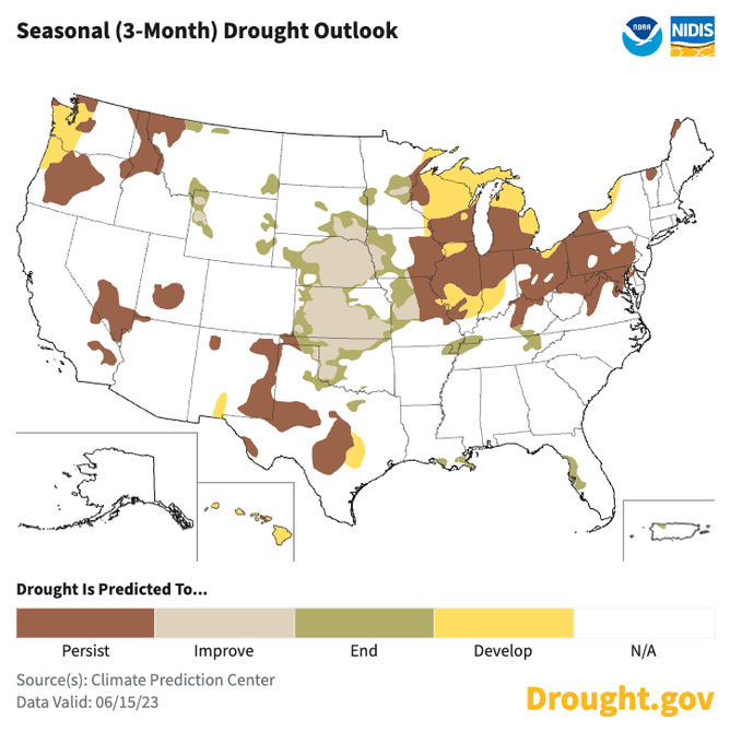
  • In the Sierra Nevada, Great Basin, and Colorado River Basin, the cool, wet, and snowy year brought major drought relief. As of mid-June, observed water year runoff has been above normal, and forecasts indicate that above-normal summer flows will persist.
  • Higher-elevation snowpack across the West remains, and is remarkably deep for mid-June in parts of the Sierra Nevada and southern Cascades.
  • Persistent and widespread anomalously cold winter temperatures, which have not occurred in recent years, aided snowpack development.
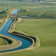
  • Lakes Powell and Mead, the two largest reservoirs in the country, have benefited this year, but it will take much more than one wet year to refill them after over 20 years of decreasing water levels.
  • Rapid snowmelt and early melt out have been problematic in parts of the Pacific Northwest. Abnormal dryness (D0) and moderate drought (D1) reappeared in Washington and Oregon over the past three weeks.
  • El Niño conditions have developed and are expected to gradually strengthen into winter. A stronger El Niño means global temperature, precipitation, and other patterns are more likely to reflect the expected El Niño impacts, such as wetter conditions in the southern U.S. and warmer conditions in the northern U.S. Historically, impacts from the transition to El Niño begin to be felt in early fall.

Abnormally cold temperatures persistent and widespread in winter 2022-23

During the past winter, unlike many recent years, anomalously cold temperatures were persistent and widespread. November through March temperatures were among the lowest third of all years since 1895 across much of the West. Temperatures in parts of California, Nevada, Oregon, and Idaho were among the coldest ten percent. Impacts of the cold temperatures included an unusual proportion of precipitation falling as snow compared to rain, snow persisting at lower elevations for longer than usual, and little mid-winter snow melt at higher elevations.

Drying and warming trend in April

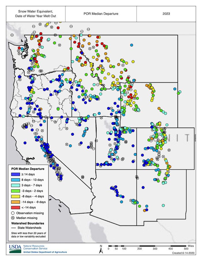
April brought a drying and warming trend to the Southwest and above-normal precipitation and cooler temperatures to Oregon and Washington, reducing some of the snowpack deficits in the Cascade Range. However, the cool and wet conditions in the Pacific Northwest were short-lived. Throughout May and into early June, temperatures across the Pacific Northwest and northern Rocky Mountains were above normal, with record warmth in parts of northern Oregon, Washington, northern Idaho, and northwestern Montana. The warm temperatures combined with relatively dry conditions have led to rapid snow loss across the region, and snow has melted one to three weeks early at many SNOTEL stations (70 sites in Oregon, Washington, Idaho, and Montana melted out more than a week early).

May snowmelt

May snowmelt reached record highs across many western regions, not just the Pacific Northwest. However, in terms of drought development, the early snowmelt was only problematic for parts of the Pacific Northwest and northern Rocky Mountains, where snowpack at the beginning of May was near normal or below normal (unlike the near-record snowpack in the Sierra Nevada, Utah, and western Colorado). The rapid snow loss, low winter precipitation, and forecasted below-normal summer runoff have renewed concerns about drought in the Pacific Northwest, with abnormal dryness (D0) and moderate drought (D1) reappearing in portions of western Washington and Oregon over the past three weeks.

Snowpack “remarkably deep” for mid-June

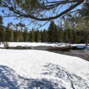
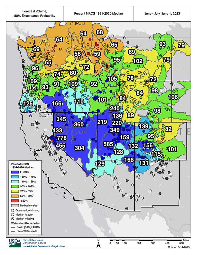
Currently, snowpack persists at higher elevations throughout the West and remains remarkably deep for mid-June in parts of the Sierra Nevada and southern Cascade Range. A few notable locations include Leavitt Lake in the central Sierra Nevada, with 92 inches of SWE remaining as of June 12; Lower Lassen Peak in the southern Cascade Range, with 82 inches of SWE remaining; and Mount Rose Ski Area near Lake Tahoe, with 43 inches of SWE remaining.

Drought relief in California and Colorado River Basin

For California, the Great Basin, and the Colorado River Basin, the cool, wet, and snowy year brought major drought relief after three consecutive dry years. Observed water year runoff in these regions was above normal through early June, and the forecasts indicate above-normal flows persisting throughout summer.

Lake Powell and Lake Mead

Major reservoirs, with the exception of Lakes Powell and Mead, have already filled or are expected to fill by the end of summer. This year was still beneficial for Lakes Powell and Mead, the two largest reservoirs in the country, but it will take much more than one wet year to refill these reservoirs after over 20 years of falling water levels. The June 12th update from the U.S. Bureau of Reclamation indicated that Lake Powell was at 37% of capacity and Lake Mead was at 31% of capacity, with forecasted April–July inflows into Powell at 167% of normal.

(Editor’s Note: NIDIS and its partners launched this snow drought effort in 2018 to provide data, maps, and tools for monitoring snow drought and its impacts as well as communicating the status of snow drought across the United States, including Alaska. Thank you to our partners for your continued support of this effort and review of these updates. For more information contact: Daniel McEvoy, Western Regional Climate Center, Amanda Sheffield, NOAA/NIDIS California-Nevada Regional Drought Information Coordinator, and Britt Parker, NOAA/NIDIS Pacific Northwest Regional Drought Information Coordinator: www.drought.gov/drought-status-updates/water-year-2023-snow-drought-conditions-summary-and-impacts-west-2023-06-15)

California snowlines-Scripps Institution of Oceanography-study-Climate Change

California Snowlines On Track To Be 1,600 Feet Higher by Century’s End

This winter produced record snowfall in California, but a new study suggests the state should expect gradually declining snowpacks, even if punctuated with occasional epic snowfalls, in the future.

An analysis by Tamara Shulgina, Alexander Gershunov, and other climate scientists at UC San Diego’s Scripps Institution of Oceanography suggest that in the face of unabated global warming, the snowlines marking where rainfall turns to snow have been rising significantly over the past 70 years. Projections by the researchers suggest the trend will continue with snowlines rising hundreds of meters higher by the second half of this century.

California snowlines and lower-elevation ski resorts

In the high Southern Sierra Nevada range, for instance, snowlines are projected to rise by more than 500 meters (1,600 feet) and even more when the mountains get precipitation from atmospheric rivers, jets of water vapor that are becoming an increasingly potent source of the state’s water supply.

“In an average year, the snowpack will be increasingly confined to the peak of winter and to the highest elevations,” the study says.

Diminished snowfall is a consequence of a changing climate in which places like California will get an increasing portion of their winter precipitation as rain instead of snow. The authors said this study and related research suggest water resource managers will need to adapt to a feast-or-famine future. California’s water supply will arrive less through the gradual melt of mountain snowpack that gets the state through hot summers and more via bursts of rain and runoff delivered by atmospheric rivers, which are boosted by warming and are associated with higher snowlines than other storms.

Warmer summers

Such events will further complicate the balancing act between protecting people and infrastructure from winter flooding and ensuring enough water supply during warmer summers.

“This work adds insight into the climate change narrative of more rain and less snow,” said California Department of Water Resources Climatologist Mike Anderson. “DWR appreciates our partnership with Scripps to help water managers develop, refine, and implement adaptation efforts as the world continues to warm and climate change impacts are realized.”

The study, funded by the U.S. Bureau of Reclamation and the DWR, appears in the journal Climate Dynamics today.

“This is the longest and most detailed account of snow accumulation in California,” said Gershunov, “resolving individual storms over 70 years of observed weather combined with projections out to 2100.”

Climate change impacts to ski industry

The authors make note of what this could mean for ski resorts around the state if climate change progresses unabated. For example, Mammoth Mountain, at an elevation between 2,400 and 3,300 meters (7,900 – 11,000 feet), is projected to receive 28 percent less snowfall in the latter half of the century. Lower elevation ski resorts such as Palisades and Northstar, both near Lake Tahoe, span elevational ranges of around 1,900 and 2,700 meters (6,200 – 8,900 feet). They are projected to lose more than 70 percent of their snow accumulation in an average winter.

“Snowlines will keep lifting”

“Observations and future climate projections show that already rising snowlines will keep lifting,” said Gershunov. “Epic winters will still be possible, though, and unprecedented snowfalls will ironically become more likely due to wetter atmospheric rivers, but they will be increasingly confined to the peak of winter and to the highest elevations of the Southern Sierra Nevada.”

Study co-authors include Kristen Guirguis, Daniel Cayan, David Pierce, Michael Dettinger, and F. Martin Ralph of Scripps Oceanography, Benjamin Hatchett of the Desert Research Institute of Reno, Nev., Aneesh Subramanian of University of Colorado at Boulder, Steven Margulis and Yiwen Fang of UCLA, and Michael L. Anderson of the California Department of Water Resources.

(Editor’s Note: Story by Robert Monroe, at UC San Diego Scripps Institution of Oceanography. The San Diego County Water Authority has partnered with the Scripps Institution of Oceanography at UC San Diego to better predict atmospheric rivers and improve water management before, during, and after those seasonal storms.)

California Faces Rapid Snowmelt From Heat Wave; Flood Fears in Yosemite, Elsewhere

After weeks of uncertainty, forecasters say an incoming California heat wave will trigger rapid snowmelt on the slopes of the Sierra Nevada and cause more flooding in portions of the San Joaquin and Owens valleys this week.

Temperatures in Central California are forecast to climb into the high 80s and mid-90s beginning Wednesday and into the weekend, with the potential for some areas to approach daily records.

California to Squander Record Rains, Snowpack in Deluge of Regulations, GOP Lawmakers Say

California’s Central Valley constitutes 1 percent of the agricultural land in the United States yet it harvests nearly a quarter of the nation’s farmed products.

The 50-mile wide, 450-mile-long breadbasket is irrigated by an intricate series of river impoundments and canals that are regulated by federal and state agencies.

Trillions of Gallons Have Soaked California. Is This the State’s Wettest Winter Ever?

A colossal amount of rain and snow has fallen on California over the past few months from a dozen atmospheric rivers: more than 78 trillion gallons of water and counting.

It’s not the wettest year the Golden State has ever seen, but it is a massive amount of water in a state that has been beset by drought for several years. The number of gallons is according to data from the National Weather Service that was compiled by meteorologist Ryan Maue.

Supply Allocation-Central Valley Project-Bureau of Reclamation

Reclamation Increases Central Valley Project 2023 Water Supply Allocations

The Bureau of Reclamation March 28, announced an increase in Central Valley Project 2023 water supply allocations. After below average precipitation in February, Reclamation announced a conservative initial water supply allocation for the CVP on Feb. 22. Additional atmospheric river systems have since boosted hydrological conditions and storage volumes, allowing for a more robust water supply allocation.

Since making initial allocations last month, Shasta Reservoir, the cornerstone of the Central Valley Project, has increased from 59% to 81%, and San Luis Reservoir, the largest reservoir south-of-Delta, from 64% to 97%. Record-breaking snowpack conditions currently exist in the Southern Sierra coupled with significant snowpack in the Central Sierra and Northern Sierra/Trinity.

2023 Central Valley Project supply allocations increased

Based on current hydrology and forecasting, Reclamation is announcing the following increases to CVP water supply allocations:

North-of-Delta Contractors

  • Irrigation water service and repayment contractors north-of-Delta are increased to 80% from 35% of their contract total.
  • Municipal and industrial water service and repayment contractors north-of-Delta are increased to 100% from 75% of their historic use.

South-of-Delta Contractors

  • Irrigation water service and repayment contractors south-of-Delta are increased to 80% from 35% of their contract total.
  • M&I water service and repayment contractors south-of-Delta are increased to 100% from 75% of their historical use.

Friant Division Contractors

  • Friant Division contractors’ water supply is delivered from Millerton Reservoir on the upper San Joaquin River and categorized by Class 1 and Class 2. The first 800,000 acre-feet of available water supply is considered Class 1; Class 2 is considered the next amount of available water supply up to 1.4 million acre-feet. Class 1 remains at 100% and Class 2 was previously increased from 20% to 70% on March 7.

Friant Dam is currently being operated for flood control purposes; as long as these conditions exist contractors are able to take delivery of all available water from Friant Dam to the maximum extent of their respective contracts.

All other CVP water supply allocations remain the same as noted in the Feb. 22 announcement.

As the water year progresses, changes in hydrology, actions that impact operations, and opportunities to deliver additional water will influence future allocations. Reclamation will continue to monitor hydrology and may adjust basin-specific allocations if conditions warrant an update. Water supply updates and past year’s allocations are posted on Reclamation California-Great Basin Region’s website.

Why is California’s Snowpack So High?

In California, the snowpack is at some of the highest levels in recorded history.

The state’s snowpack accumulates in the Sierra Nevada—a mountain range that stretches for 400 miles from Northern California southward to the Great Basin. The snowpack, which melts into the state’s reservoirs, provides about a third of California’s total water supply.