The United Nations Climate Conference, called COP28, begins on Thursday in Dubai and students and faculty from UC San Diego (UCSD) will be there.
The UN climate conference is a global meeting of politicians and scientists that have a strong bearing on the fight against global warming. It’s where the Paris Agreement was adopted in 2015.
https://www.waternewsnetwork.com/wp-content/uploads/2024/04/WNN-Horizontal-White-Blue2.png00Chelsea Camposhttps://www.waternewsnetwork.com/wp-content/uploads/2024/04/WNN-Horizontal-White-Blue2.pngChelsea Campos2023-11-29 08:20:182023-11-29 08:28:46UC San Diego, Scripps Oceanography Sends Delegation to Cop28, the UN Climate Conference
The University of California San Diego has received two five-year National Science Foundation (NSF) grants totaling $6.6 million to fund research hubs in Southern California and Puerto Rico.
https://www.waternewsnetwork.com/wp-content/uploads/2024/04/WNN-Horizontal-White-Blue2.png00Mike Leehttps://www.waternewsnetwork.com/wp-content/uploads/2024/04/WNN-Horizontal-White-Blue2.pngMike Lee2022-10-26 10:08:062022-10-26 10:16:37UC San Diego Launches Two Projects on the Impact of Climate Change on Coastlines and People
A research team at Scripps Institution of Oceanography at UC San Diego has found that flood damages triggered by atmospheric river storms may triple from $1 billion a year to over $3 billion a year by the end of the century unless action is taken to reduce global greenhouse gas emissions.
https://www.waternewsnetwork.com/wp-content/uploads/2024/04/WNN-Horizontal-White-Blue2.png00Mike Leehttps://www.waternewsnetwork.com/wp-content/uploads/2024/04/WNN-Horizontal-White-Blue2.pngMike Lee2022-08-25 10:54:002022-08-25 11:01:52Climate Change Projected to Increase Atmospheric River Flood Damages in the United States
A team led by Kristen Guirguis, a climate researcher at Scripps Institution of Oceanography at UC San Diego, found evidence that the risk of hazardous weather is increasing in the Southwest.
The researchers investigated the daily relationships among four major modes of weather affecting California. How they interact governs the formation of weather events such as atmospheric rivers capable of bringing torrential rains and Santa Ana winds that can spread devastating wildfires.
“This study suggests that weather patterns are changing in a way that enhances hot, dry Santa Ana winds, while reducing precipitation frequency in the Southwest,” said Guirguis. “These changes in atmospheric circulation are raising the risk of wildfires during California winters.”
Dillard Road is flooded near the Hwy 99 off ramp, located south of Elk Grove, California. Photo credit: Florence Low / California Department of Water Resources.
The basis of the research was an examination of the dominant atmospheric circulation patterns over the North Pacific Ocean, known as Baja-Pacific, Alaskan-Pacific, Canadian-Pacific, and Offshore-California modes. What distinguishes them from each other are the relative positions of ridges and troughs in the atmosphere.
Weather patterns and a warmer atmosphere
The research team identified 16 recurring weather patterns that are created daily as these modes interact with each other. One product of the work was a summary of California weather patterns from 1949 to 2017. The patterns associated with the formation of dry gusty Santa Ana winds that often stoke Southern California fires are becoming more frequent. Patterns associated with what might be considered “normal” rainfall are decreasing in the Southwest thus promoting drought, but patterns associated with extreme precipitation and strong atmospheric river episodes have remained steady over the study period. The researchers noted that while the patterns associated with heavy precipitation and strong atmospheric rivers have not changed in frequency, a warmer atmosphere is capable of holding more water so these storms are becoming more damaging.
Challenges for wildfire and water resource management
The results suggest an increasing probability of compounding environmental hazards during California winters, said the research team. Though winter atmospheric rivers are the antithesis of hot, dry Santa Ana wind conditions, sequences of wildfires followed by strong atmospheric rivers often compound the damage from fires when they trigger flash floods and destructive debris flows from burn scars.
Photo of the Thomas Fire taken from a Santa Barbara beach. Photo credit: Carsten Schertzer / iStock.
“This spells challenges for wildfire and water resource management and provides observational support to our previous results projecting that California will increasingly have to depend on potentially hazardous atmospheric rivers and floodwater for water resource generation in a warming climate,” said study co-author Alexander Gershunov, a Scripps Oceanography climate scientist.
Study authors say this work is helping to inform an experimental subseasonal-to-seasonal (S2S) forecast product being developed at Scripps Oceanography’s Center for Western Weather and Water Extremes (CW3E) that predicts extreme weather in California including atmospheric river landfalls, Santa Ana winds, drought, and heat waves.
The U.S. Department of the Interior via the Bureau of Reclamation and the Southwest Climate Adaptation Science Center, the California Department of Water Resources, and the Regional Integrated Sciences and Assessments (RISA) California—Nevada Climate Applications Program and the International Research Applications Program of the National Oceanic and Atmospheric Administration funded the study. Additional funding was provided by the University of California Office of the President MRPI grant.
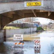
High water levels on the Tuolumne River close River Road in the city of Modesto, California, part of Stanislaus County. Photo credit: Dale Kolke / California Department of Water Resources.
The San Diego County Water Authority has a partnership with the Scripps Institution of Oceanography at UC San Diego to better predict atmospheric rivers and improve water management before, during and after seasonal storms.
(Editors Note: Study co-authors include Benjamin Hatchett of the Desert Research Institute in Nevada; Tamara Shulgina, Michael DeFlorio, Rosana Aguilera, achel Clemesha, Tom Corringham, Luca Delle Monache, and Marty Ralph of CW3E at Scripps Oceanography; Aneesh Subramanian and David Reynolds of the University of Colorado Boulder; Janin Guzman-Morales of the University of California Santa Barbara; and Alex Tardy and Ivory Small of the National Weather Service.)
https://www.waternewsnetwork.com/wp-content/uploads/2022/08/Flooding-primary-photo-UCSD-study.jpg450845Mike Leehttps://www.waternewsnetwork.com/wp-content/uploads/2024/04/WNN-Horizontal-White-Blue2.pngMike Lee2022-08-12 13:16:102022-08-12 13:16:10More Evidence that California Weather is Trending Toward Extremes
In earlier days of the COVID-19 pandemic, before diagnostic testing was widely available, it was difficult for public health officials to keep track of the infection’s spread or predict where outbreaks were likely to occur. Attempts to get ahead of the coronavirus that causes the disease are still complicated by the fact that people can be infected and spread the virus even without experiencing symptoms themselves.
https://www.waternewsnetwork.com/wp-content/uploads/2024/04/WNN-Horizontal-White-Blue2.png00Kimberlyn Velasquezhttps://www.waternewsnetwork.com/wp-content/uploads/2024/04/WNN-Horizontal-White-Blue2.pngKimberlyn Velasquez2021-03-16 10:13:212021-03-16 10:14:17Sewage-Handling Robots Help UCSD Team Predict Coronavirus Outbreaks in San Diego
UC San Diego says it detected traces of the novel coronavirus in five areas of campus over the weekend after it greatly expanded its search for the pathogen in wastewater samples drawn from dozens of buildings.
The positive tests could involve as many as 14 residential halls and two laundries. But school officials also said Tuesday the findings also could represent only a small number of sites and very few infections.
https://www.waternewsnetwork.com/wp-content/uploads/2024/04/WNN-Horizontal-White-Blue2.png00Mike Leehttps://www.waternewsnetwork.com/wp-content/uploads/2024/04/WNN-Horizontal-White-Blue2.pngMike Lee2020-11-25 09:26:032020-12-03 14:30:27UC San Diego Detects Coronavirus in Wastewater Samples From Five Areas of Campus
UC San Diego Chancellor Pradeep Khosla on Tuesday alerted students, faculty and staff that the university’s wastewater monitoring system detected SARS CoV-2 — the virus which causes COVID-19 — in multiple sites on Sunday and Monday.
“Our early detection system identified active virus in the wastewater outflow in the five campus areas from 11 a.m. on Sunday, November 22 to 1 p.m. on Monday, November 23,” Khosla said.
UC San Diego will receive a $39 million grant to build a testbed to allow universities, utilities and industry leaders to gain a better understanding of how to integrate renewable energy resources into the power grid, it was announced Monday.
https://www.waternewsnetwork.com/wp-content/uploads/2024/04/WNN-Horizontal-White-Blue2.png00Mike Leehttps://www.waternewsnetwork.com/wp-content/uploads/2024/04/WNN-Horizontal-White-Blue2.pngMike Lee2020-11-03 09:43:532020-11-06 16:22:36UCSD Gets $39 Million Grant for Renewable Energy Testbed
Researchers at the University of California San Diego report in a new study a way to improve groundwater monitoring by using a remote sensing technology (known as InSAR), in conjunction with climate and land cover data, to bridge gaps in the understanding of sustainable groundwater in California’s San Joaquin Valley.
https://www.waternewsnetwork.com/wp-content/uploads/2024/04/WNN-Horizontal-White-Blue2.png00Chelsea Camposhttps://www.waternewsnetwork.com/wp-content/uploads/2024/04/WNN-Horizontal-White-Blue2.pngChelsea Campos2020-10-07 09:57:132020-10-12 10:55:48Researchers Use Satellite Imaging to Map Groundwater Use In California’s Central Valley
As the beginning of the school year nears, the university is preparing to ramp up its testing of sewage for the coronavirus. The goal: Monitor the progress of the pandemic on campus and catch outbreaks before it’s too late to control them. Along those lines, UCSD on Saturday sent out its first campus-wide email alert about the detection of the virus in sewage from one of its seven colleges.
https://www.waternewsnetwork.com/wp-content/uploads/2024/04/WNN-Horizontal-White-Blue2.png00Mike Leehttps://www.waternewsnetwork.com/wp-content/uploads/2024/04/WNN-Horizontal-White-Blue2.pngMike Lee2020-09-08 09:20:382020-09-11 09:53:37A New Kind of College Exam: UCSD is Testing Sewage for COVID-19

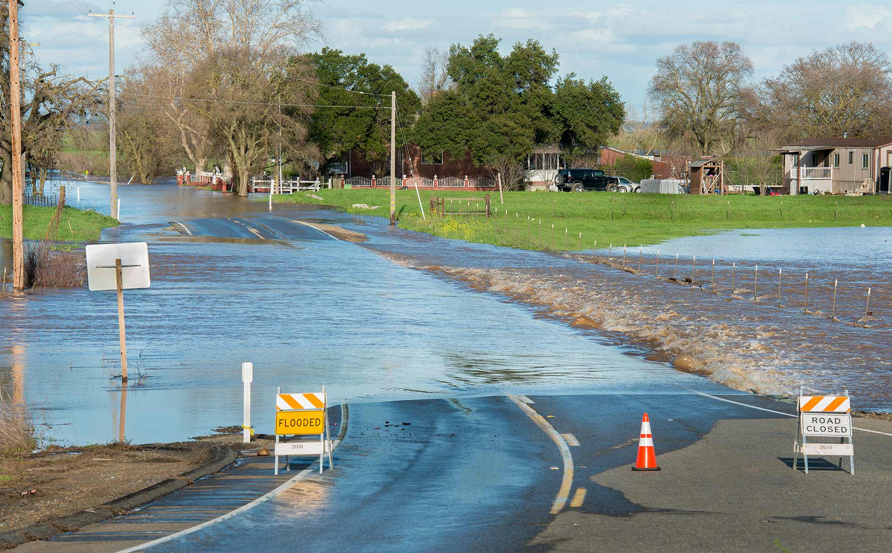 Dillard Road is flooded near the Hwy 99 off ramp, located south of Elk Grove, California. Photo credit: Florence Low / California Department of Water Resources.
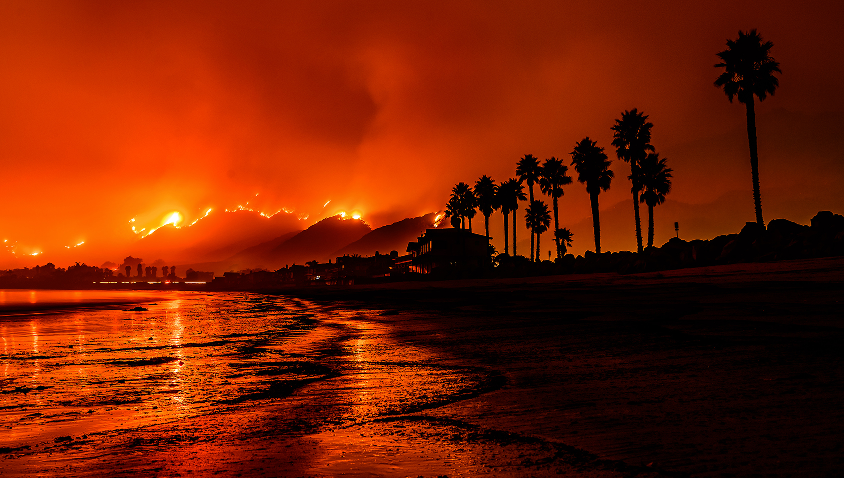 Photo of the Thomas Fire taken from a Santa Barbara beach. Photo credit: Carsten Schertzer / iStock.
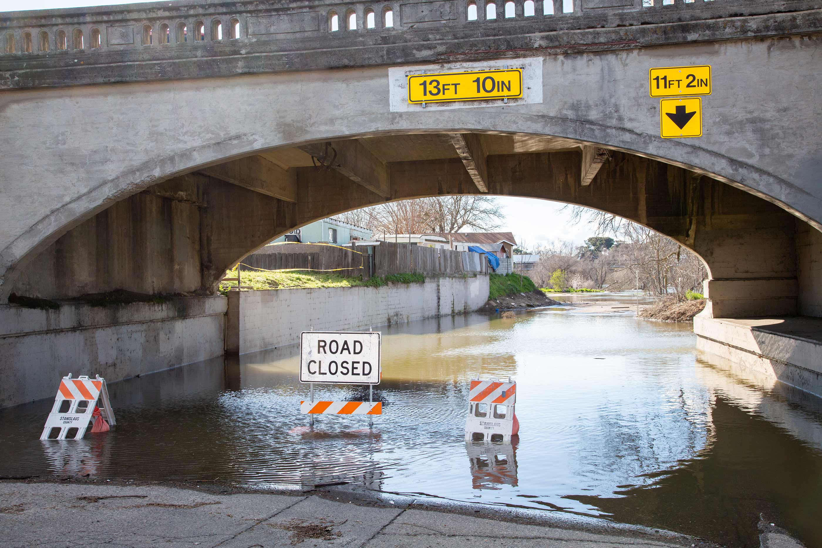 High water levels on the Tuolumne River close River Road in the city of Modesto, California, part of Stanislaus County. Photo credit: Dale Kolke / California Department of Water Resources.
