Posts

Atmospheric River Hits California. Here’s What That Means.

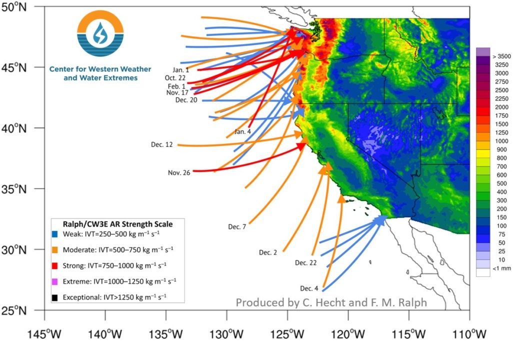
As the United States begins to recover from a week of severe weather that left dozens dead, more storms are already in the forecast. An atmospheric river began moving through California on Tuesday, with another atmospheric river predicted for later in the week.

Forty Atmospheric Rivers Have Hit West Coast Since October

More than three dozen atmospheric rivers made landfall on the West Coast from fall through early spring, but a lack of strong events in California led to the development of drought conditions in parts of the state.

An atmospheric river is a thin, but long plume of moisture in the atmosphere that stretches from the Pacific Ocean tropics or subtropics into higher latitudes. They provide a boost to the rain and snow totals produced by storm systems taking aim at the West Coast, mostly from late fall into early spring. Although these events can bring hazardous impacts, they are also beneficial since they help replenish the water supply in the West.

atmospheric rivers-SIO-graphic 2020

The Center for Western Weather and Water Extremes at Scripps Institution of Oceanography studies atmospheric rivers and other extreme weather. Graphic: CW3E Scripps/UC San Diego

New Storm To Spread Snow, Ice, Rain Coast To Coast

A new storm from the West will spread snow, ice and rain through parts of the central and eastern states into early next week.

The energy from this next storm will move into the West Coast by Saturday. It will then spawn a low pressure system in the Southern Plains, which will track toward the eastern states early next week.

There will likely be snow and some ice where the moisture pulled in by the low overlaps with cold air supplied by high pressure to its north. Rain and thunderstorms are expected in the South.

California Storm Parade Continues Friday With More Rain, Feet of Sierra Snow Through The Weekend

Another Pacific storm will surge into California Friday and last into the weekend wringing out feet of Sierra snow and more rain that could trigger additional flooding and debris flows.

Satellite imagery clearly shows the next system waiting in the wings to soak the Golden State beginning Friday.

Wednesday’s storm dumped about an inch of rain in downtown L.A. and San Diego, with locally higher amounts over the mountains.

Levee Break Shuts Down California Highway, Strands Students Overnight At School

A broken levee shut down U.S. Highway 101 in Northern California on Wednesday and forced about 30 students and teachers to spend the night in their school’s gym.

Meanwhile, a nursing home in a neighboring county evacuated its residents because of flooding.

The levee near the school in Chualar was partially breached about 2 p.m., KSBW reported. The rain came as an atmospheric river storm drenched the state.

Two More Rounds of Rain, Mountain Snow Ahead For California Into This Weekend

California will receive two more rounds of rain and mountain snow through this weekend, continuing a stormy period that kicked off before Thanksgiving.

For now, drier conditions have developed and generally will be in place for most of Tuesday.

A low pressure system brought over 2 inches of rain to parts of the Central Valley north of Fresno. Some foothills and mountain locations below snow level in the Sierra Nevada, Santa Cruz Mountains into Napa and Sonoma counties measured over 4 inches of rain.

Powerful Storm Will Bring Snow, Rain And Strong Winds From West to Central And Eastern U.S. Into This Weekend

Snow, rain and strong winds will make travel conditions difficult in parts of the West this week from an powerful storm that will slowly spread toward the central and eastern United States into this weekend.

The intensifying storm is located in the northeastern Pacific Ocean and will move into Oregon and Northern California on Tuesday. This storm will undergo bombogenesis before it moves inland. This means it will be a bomb cyclone since its pressure will drop at least 24 millibars within 24 hours, making it an intense storm when it strikes.

Winter 2019-20 Will Likely Be Warmer Than Average in Southern U.S. & Colder Than Average in Parts of Northern Tier

A warmer winter is in store for much of the southern U.S., while the northern tier of the country shivers, our new winter outlook shows. In addition, NOAA’s winter outlook indicates that parts of the flood-weary Northern Plains and Midwest may see a wetter-than-average December through February.

Winter temperatures will likely be near to warmer than average for much of the southern U.S., but parts of the northern tier won’t be so lucky. Temperatures there are projected to be near to slightly below average.

NOAA Predicts Warmer Than Average Temperatures For The Entire U.S. Through December

Fall officially arrived with the autumnal equinox at 3:50 a.m. EDT Monday morning, but finding the colder weather more typical of autumn may be a difficult task, according to the latest three-month outlook from NOAA’s Climate Prediction Center.

The CPC predicts that the entire country will have warmer than average temperatures from October through December. You read that correctly: No areas of the United States are forecast to have below average temperatures when averaged over that three-month period.

Faster Water Cycle Brings Worries Of Increased Drought And Flooding In The United States

New calculations of changes in the water cycle over the United States pinpoint several areas that could become increasingly dry over the next few decades, a new study says. They also showed areas that could see more flooding.

The water cycle is the movement of water on the planet — from falling as precipitation, such as rain, ice or snow, to being absorbed in the soil or flowing into groundwater and streams and then being evaporated to start all over again.