Tag Archive for: National Weather Service

El Niño-NOAA-Northern Hemisphere-Winter

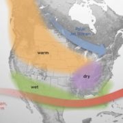
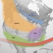
El Niño Anticipated to Continue Through the Northern Hemisphere Winter

El Niño is anticipated to continue through the Northern Hemisphere winter (with a greater than 95% chance through January – March 2024). An El Niño Advisory remains in effect.

In August, sea surface temperatures (SSTs) were above average across the equatorial Pacific Ocean [Fig. 1], with strengthening in the central and east-central Pacific. All of the latest weekly Niño indices were in excess of +1.0°C: Niño-4 was +1.1°C, Niño-3.4 was +1.6°C, Niño-3 was +2.2°C, and Niño1+2 was +2.9°C [Fig. 2]. Area-averaged subsurface temperatures anomalies increased compared to July [Fig. 3] in association with anomalous warmth in the central and eastern equatorial Pacific Ocean [Fig. 4]. Tropical atmospheric anomalies were also consistent with El Niño. Over the east-central Pacific, low-level winds were anomalously westerly, while upper-level winds were anomalously easterly. Convection was slightly enhanced around the International Date Line, stretching into the eastern Pacific, just north of the equator. Convection was mostly suppressed around Indonesia [Fig. 5]. The equatorial Southern Oscillation Index (SOI) and the traditional station-based SOI were both significantly negative. Collectively, the coupled ocean-atmosphere system reflected El Niño.

El Niño Winter

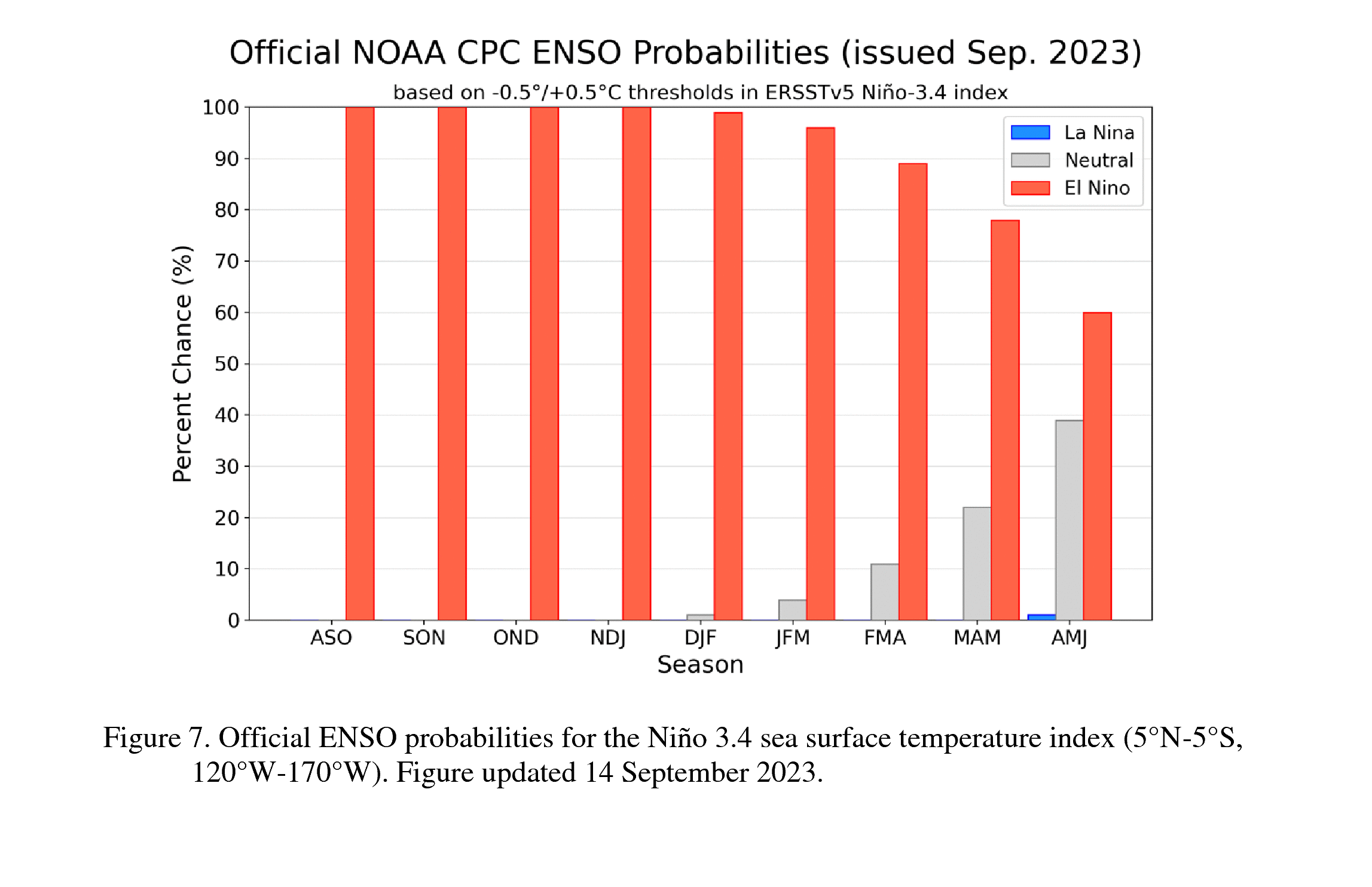
The most recent IRI plume indicates El Niño will persist through the Northern Hemisphere winter 2023-24 [Fig. 6]. Despite nearly the same ensemble mean amplitude as last month, the shorter forecast horizon means that the odds of at least a “strong” El Niño (≥1.5°C for the November-January seasonal average in Niño-3.4) have increased to 71%. However, a strong El Niño does not necessarily equate to strong impacts locally, with the odds of related climate anomalies often lower than the chances of El Niño itself (e.g., CPC’s seasonal outlooks). In summary, El Niño is anticipated to continue through the Northern Hemisphere winter (with greater than 95% chance through January – March 2024; [Fig. 7]).

Next El Niño update in October

This discussion is a consolidated effort of the National Oceanic and Atmospheric Administration (NOAA), NOAA’s National Weather Service, and their funded institutions. Oceanic and atmospheric conditions are updated weekly on the Climate Prediction Center web site (El Niño/La Niña Current Conditions and Expert Discussions). Additional perspectives and analysis are also available in an ENSO blog. A probabilistic strength forecast is available here. The next ENSO Diagnostics Discussion is scheduled for 12 October 2023.

El Niño

El Niño is anticipated to continue through the Northern Hemisphere winter (with a greater than 95% chance through January – March 2024). An El Niño Advisory remains in effect. Graphic: NOAA

Full discussion on the latest El Niño update from the National Weather Service Climate Prediction Center: www.cpc.ncep.noaa.gov/products/analysis_monitoring/enso_advisory/ensodisc.shtml


El Niño is Coming This Winter. The Question is, Will It Be a Whopper?

San Diego County’s fragile shoreline and vulnerable beachfront properties could be in for a rough winter, according to the California Coastal Commission, the National Weather Service and some top San Diego scientists.

“We are looking at an emerging El Niño event,” staff geologist Joseph Street told the Coastal Commission at its meeting Wednesday in Eureka.

July Keeps Sizzling as Phoenix Hits Another 110-Degree Day and Wildfires Spread in California

Phoenix sizzled through its 31st consecutive day of at least 110 degrees Fahrenheit (43.3 Celsius) and other parts of the country grappled Sunday with record temperatures after a week that saw significant portions of the U.S. population subject to extreme heat.

The National Weather Service said Phoenix climbed to a high of 111 F (43.8 Celsius) before the day was through.

With 13 Inches of Rain This Wet Season, San Diego County is Nearly Drought-Free

With an exceptionally rainy season for California, much of the state is free from drought, including most of San Diego County, according to the U.S. Drought Monitor.

The latest drought monitor map released Thursday shows all but 11% of San Diego County remains in some form of drought, which is the same as last week. But that’s significantly down from 3 months ago when all of San Diego County was in some form of drought.

Trillions of Gallons Have Soaked California. Is This the State’s Wettest Winter Ever?

A colossal amount of rain and snow has fallen on California over the past few months from a dozen atmospheric rivers: more than 78 trillion gallons of water and counting.

It’s not the wettest year the Golden State has ever seen, but it is a massive amount of water in a state that has been beset by drought for several years. The number of gallons is according to data from the National Weather Service that was compiled by meteorologist Ryan Maue.

No Telling How Much More Snow Coming for Sierra Nevada

No one really knows how much snow fell on the infamous Donner Party when the pioneers were trapped atop the Sierra Nevada for months and dozens died near Lake Tahoe in the winter of 1846-47.

But this season has now etched its way into the history books as the second snowiest in the 77 years of record-keeping at the Central Sierra Snow Lab — more than 56.4 feet (677 inches, 17.2 meters) with no end in sight.

Another Atmospheric River Will Thrash Storm-Ravaged California, Threatening More Flooding and Hurricane-force Wind Gusts

Swaths of California still saturated by ruthless storms will get walloped by another atmospheric river, spawning fears of renewed flooding and forcing some residents to flee.

The state has already been hammered by at least 11 atmospheric rivers this season. An atmospheric river is like a fire hose that carries saturated air from the tropics to higher latitudes, dumping relentless rain or snow.

Rainfall Breaks Records Across San Diego County, With Flooding Closing Roads

Record rainfall was reported across San Diego County on Wednesday, with numerous roads closed by flooding.

Oceanside Harbor received a record 4.21 inches, Vista 2.24 inches, Alpine 1.80 inches, Ramona 1.73 inches and Campo 1.17 inches.

Soggy California Drenched Anew as Nor’easter Buries New England, New York

The latest in a series of atmospheric river storms soaked California on Tuesday, bringing another deluge of rain to the already-saturated state, while a Nor’easter swirling over New York and New England prompted emergency orders and closed roads.

Several inches of rain was forecast in some areas of California, while as much as 3 feet (0.9 m) of fresh snow was expected in high-mountain elevations where snowdrifts already reach rooftops, according to the National Weather Service.

Here’s How Much Rain Fell in 43 San Diego County Communities Through Early Wednesday

As the rainfall figures below show, San Diego County received heavy precipitation overnight and early Wednesday from a Pacific storm that was enhanced by moisture from the sub-tropics. The system also has kicked up 26 mph winds at San Diego International Airport. And it created fog that reduced the carrier Carl Vinson to a silhouette in San Diego Bay.

The National Weather Service said that an additional 0.50 inches to 0.70 inches could fall by Wednesday night.