Tag Archive for: El Niño

Earth Just Had its Warmest August — and Summer — on Record, Spurring Dire Warnings

Amid a backdrop of extreme weather events and devastating wildfires, federal and international officials this week issued dire warnings about record-setting temperatures and the worsening effects of climate change.

Last month was the planet’s warmest August on record, and the Northern Hemisphere experienced its hottest meteorological summer, the National Oceanic and Atmospheric Administration announced Thursday.

“Global marine heat waves and a growing El Niño are driving additional warming this year, but as long as emissions continue driving a steady march of background warming, we expect further records to be broken in the years to come,” read a statement from NOAA chief scientist Sarah Kapnick.

El Niño-NOAA-Northern Hemisphere-Winter

El Niño Anticipated to Continue Through the Northern Hemisphere Winter

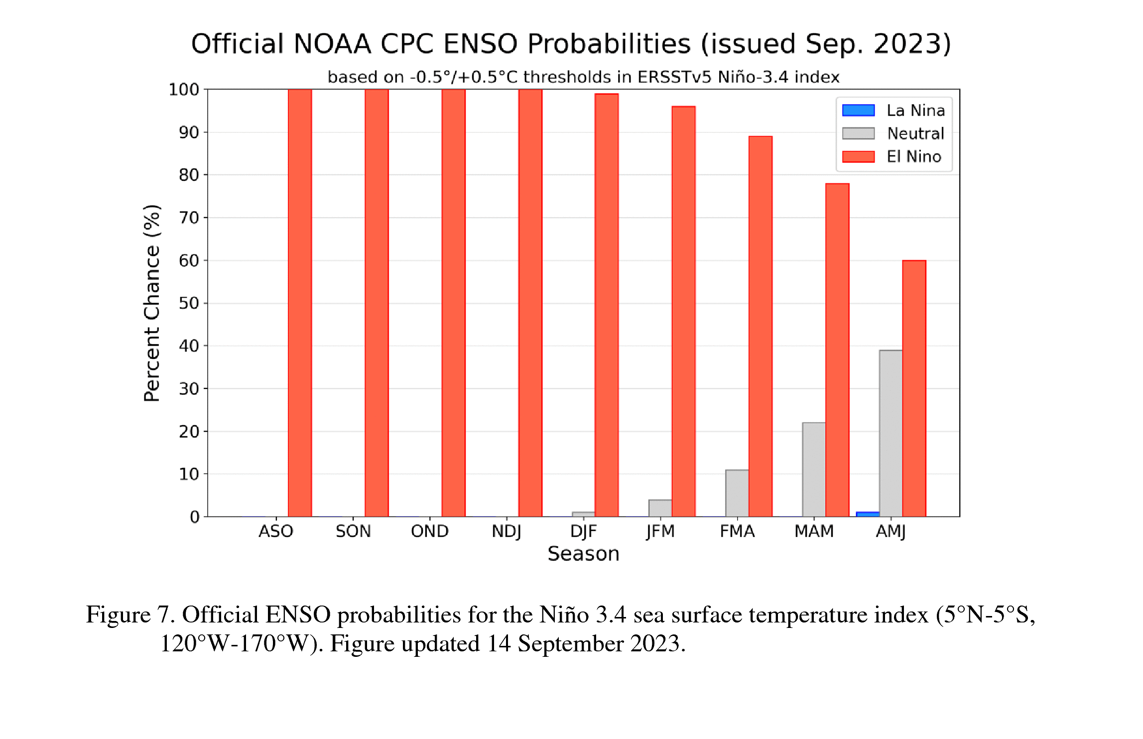
El Niño is anticipated to continue through the Northern Hemisphere winter (with a greater than 95% chance through January – March 2024). An El Niño Advisory remains in effect.

In August, sea surface temperatures (SSTs) were above average across the equatorial Pacific Ocean [Fig. 1], with strengthening in the central and east-central Pacific. All of the latest weekly Niño indices were in excess of +1.0°C: Niño-4 was +1.1°C, Niño-3.4 was +1.6°C, Niño-3 was +2.2°C, and Niño1+2 was +2.9°C [Fig. 2]. Area-averaged subsurface temperatures anomalies increased compared to July [Fig. 3] in association with anomalous warmth in the central and eastern equatorial Pacific Ocean [Fig. 4]. Tropical atmospheric anomalies were also consistent with El Niño. Over the east-central Pacific, low-level winds were anomalously westerly, while upper-level winds were anomalously easterly. Convection was slightly enhanced around the International Date Line, stretching into the eastern Pacific, just north of the equator. Convection was mostly suppressed around Indonesia [Fig. 5]. The equatorial Southern Oscillation Index (SOI) and the traditional station-based SOI were both significantly negative. Collectively, the coupled ocean-atmosphere system reflected El Niño.

El Niño Winter

The most recent IRI plume indicates El Niño will persist through the Northern Hemisphere winter 2023-24 [Fig. 6]. Despite nearly the same ensemble mean amplitude as last month, the shorter forecast horizon means that the odds of at least a “strong” El Niño (≥1.5°C for the November-January seasonal average in Niño-3.4) have increased to 71%. However, a strong El Niño does not necessarily equate to strong impacts locally, with the odds of related climate anomalies often lower than the chances of El Niño itself (e.g., CPC’s seasonal outlooks). In summary, El Niño is anticipated to continue through the Northern Hemisphere winter (with greater than 95% chance through January – March 2024; [Fig. 7]).

Next El Niño update in October

This discussion is a consolidated effort of the National Oceanic and Atmospheric Administration (NOAA), NOAA’s National Weather Service, and their funded institutions. Oceanic and atmospheric conditions are updated weekly on the Climate Prediction Center web site (El Niño/La Niña Current Conditions and Expert Discussions). Additional perspectives and analysis are also available in an ENSO blog. A probabilistic strength forecast is available here. The next ENSO Diagnostics Discussion is scheduled for 12 October 2023.

El Niño

El Niño is anticipated to continue through the Northern Hemisphere winter (with a greater than 95% chance through January – March 2024). An El Niño Advisory remains in effect. Graphic: NOAA

Full discussion on the latest El Niño update from the National Weather Service Climate Prediction Center: www.cpc.ncep.noaa.gov/products/analysis_monitoring/enso_advisory/ensodisc.shtml


El Niño is Coming This Winter. The Question is, Will It Be a Whopper?

San Diego County’s fragile shoreline and vulnerable beachfront properties could be in for a rough winter, according to the California Coastal Commission, the National Weather Service and some top San Diego scientists.

“We are looking at an emerging El Niño event,” staff geologist Joseph Street told the Coastal Commission at its meeting Wednesday in Eureka.

Will Northern California See Another Stormy Winter This Year? Here’s What Experts Predict

This summer’s heat seems to be easing down as temperatures decline to the 70s and 80s , a reminder that seasons are changing and winter is coming. In June, the National Oceanic and Atmospheric Association officially declared an El Niño, predicting that it will strengthen in the northern hemisphere this winter. But it’s too soon to know exactly what this winter will look like for California.


Coastal Areas Will Face Record ‘Sunny Day’ Flooding in 2024 — NOAA

Eight locations along the nation’s Atlantic and Pacific coasts experienced a record surge in high-tide flooding days last year, a trend intensified by rising sea levels and weather patterns that El Niño is expected to escalate in 2024, NOAA said Tuesday.

Coastal communities are expected to face three times as many high-tide, or “sunny day,” flooding instances through next April, compared to two decades ago, agency officials said in a press call.

Multiyear El Niño and La Niña Events Likely to Increase, Researchers Say

Climate scientists are bracing for potentially lengthy El Niño and La Niña events, according to a new study revealing how the underlying mechanism for climate variability is responding to increased greenhouse gas emissions in unpredicted ways and inducing El Niño-like conditions after volcanic eruptions.

The research published in Nature Wednesday details recently discovered trends of the “Pacific Walker Circulation,” (PWC) an atmospheric phenomenon relating to east-west circulation along the equatorial Pacific.

Scientists Look Beyond Climate Change and El Niño for Other Factors That Heat Up Earth

Scientists are wondering if global warming and El Niño have an accomplice in fueling this summer’s record-shattering heat.

The European climate agency Copernicus reported that July was one-third of a degree Celsius (six-tenths of a degree Fahrenheit) hotter than the old record. That’s a bump in heat that is so recent and so big, especially in the oceans and even more so in the North Atlantic, that scientists are split on whether something else could be at work.

Scientists agree that by far the biggest cause of the recent extreme warming is climate change from the burning of coal, oil and natural gas that has triggered a long upward trend in temperatures. A natural El Niño, a temporary warming of parts of the Pacific that changes weather worldwide, adds a smaller boost. But some researchers say another factor must be present.

As Threat of El Niño Winter Looms, Newsom Signs Order to Hasten Levee Repairs

As forecasters sound the alarm about another potentially wet California winter fueled by El Niño, Gov. Gavin Newsom is taking urgent but controversial measures to prevent a repeat of the devastating floods that befell the state earlier this year.

An executive order signed by the governor this month will streamline levee repairs and debris removal to help protect and prepare communities for another potential inundation.

snowmelt runoff-streamflow-records

Snowmelt Runoff Sets Streamflow Records in the Southwest

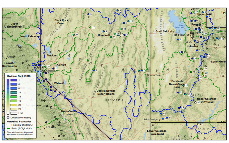
Across the western U.S., many areas received record or near-record amounts of snowpack over the winter. With the spring and summer temperatures melting the abundant snow, a record volume of streamflow has been recorded in several basins in the southwestern U.S., providing more water for the area later into the summer than is typically seen.

Snowmelt runoff in Walker and Carson basins

The Walker and Carson basins near the California-Nevada border, for example, have reported the largest volume of streamflow for April through July that has ever been observed in roughly a century, when the records began. The ample runoff is helping fill reservoirs that have been depleted from years of drought conditions.
Weekly U.S. Drought Monitor: Cooler Northwest, Warmer Southwest

Dry conditions dominated the West and southern Plains, coupled with above-normal temperatures. Precipitation was most widespread throughout much of the upper Midwest and central Plains and into the Northeast. Almost the entire country had near- to above-normal temperatures this last week, with the greatest departures over the Southwest and central Plains where temperatures were at least 4-7 degrees above normal.

Cooler-than-normal temperatures were recorded in the Pacific Northwest with departures of 3-6 degrees below normal. At the end of the current U.S. Drought Monitor period, significant rains developed over portions of the Midwest and central Plains, and they will be accounted for in the next analysis.

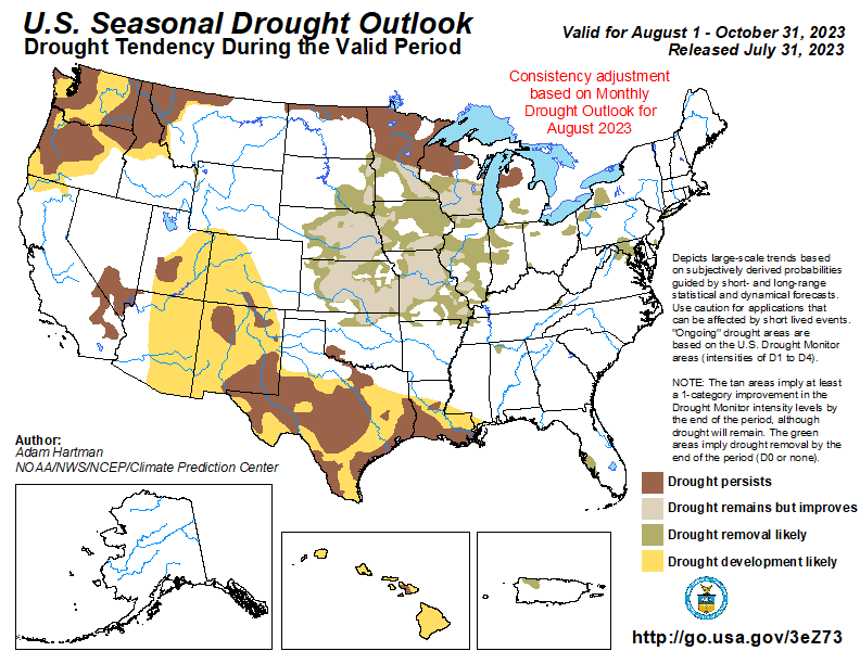
U.S. Seasonal Drought Outlook

Central portions of the Intermountain West may be spared degradation, as those areas are still showing residual benefits from above normal winter snowpack leading up to the summer, in addition to periods of above normal rainfall during the last 60 to 90 days. Seasonal temperature and precipitation outlooks, ENSO, and climatology favor widespread drought improvement and removal across the central U.S. However, drought persistence is favored across the Upper Midwest, although there is the potential for localized improvements.” Read full assessment: cpc.ncep.noaa.gov/products/expert_assessment/sdo_summary.php.
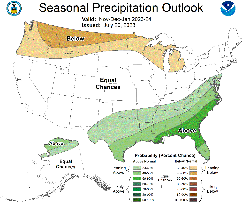
Seasonal Precipitation Outlook: November, December, January 2023-24

Colors show where total precipitation has an increased chance of being higher or lower than usual during the next three months. The darker the shading, the greater the chance for the indicated condition. White areas have equal chances for precipitation totals that are below, near, or above the long-term average (median) for the next three months.

Climate scientists base future climate outlooks on current patterns in the ocean and atmosphere. They examine projections from climate and weather models and consider recent trends. They also check historical records to see how much precipitation fell when patterns were similar in the past.
Copernicus Climate Change Service: July 2023 sees multiple global temperature records broken

July 2023 highlights:

  • The global average temperature for July 2023 is confirmed to be the highest on record for any month.
  • Antarctic sea ice extent continued to break records for the time of year, with a monthly value 15% below average, by far the lowest July extent since satellite observations began.
  • July 2023 was wetter than average over most of northern Europe and in a region from the Black Sea and Ukraine to northwestern Russia. Drier than average conditions were experienced across the Mediterranean basin, with Italy and southeastern Europe having the largest anomalies.

July 2023 NOAA State of Climate Report

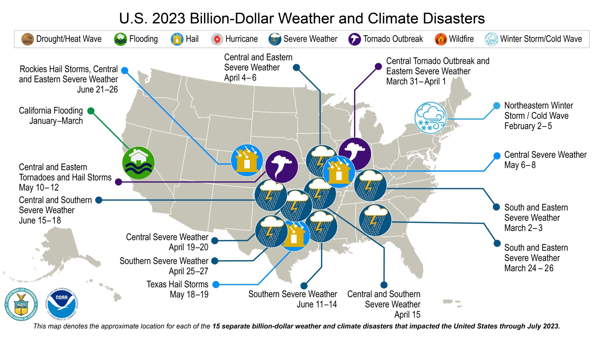
Record-high temps & devastating floods struck the U.S. 15 separate billion-dollar disasters occurred during the 1st 7 months of 2023. More from NOAA’s July State of Climate report.
(Editor’s Note: Content for this story comes from the Natural Resources Conservation Service, which produces a weekly report using data and products from the National Water and Climate Center and other agencies. The report focuses on seasonal snowpack, precipitation, temperature, and drought conditions in the United States.)

El Niño Increases Global Health Threats That Require a One Health Response

According to the National Oceanic and Atmospheric Administration (NOAA), El Niño is here. Its arrival likely augurs an increased occurrence of health threats around the world. Brought on by deviations in sea-surface temperatures, El Niño negatively impacts human, animal, and plant health—and their interconnections. According to the World Health Organization (WHO), the changing atmospheric conditions brought on by El Niño will increase the risks for droughts, fires, floods, and storms that can lead to the increased incidence of vector-borne diseases, food insecurity, and heat stress, among other health threats.