Posts

How Bad Will California’s Winter Be? Weather Outlook for North and South

El Niño has arrived, and the climate pattern is likely to bring above-average moisture to the southern U.S. this winter.

El Niño is one of two climate patterns that greatly impact Earth’s weather. La Niña recently culminated in the spring, ending a multiyear period in which the pattern influenced the weather. El Niño started in June, and the National Oceanic and Atmospheric Administration’s (NOAA) most recent update has identified El Niño as having high odds of being historically strong.

That means parts of California could see another wet winter, a welcome weather pattern as many of the state’s lakes and reservoirs continue to recover from a years-long drought. But an El Niño year doesn’t guarantee excess moisture in Southern California.

Early Onset of Fall Rains in Northstate Offers Positive Outlook for Water Year, Says State Climatologist

Rainy weather moved through the Northstate a little earlier than a normal season on Monday.

According to the Department of Water Resources (DWR), the possible rain we will see on Monday is starting the first fall precipitation about a week earlier than average.

An El Niño Winter is Coming. Here’s What That Could Mean for the US

Fall has only just begun, but it’s not too soon to look ahead to winter, especially since this one may look drastically different than recent years because of El Niño.

This winter will be the first in a few years to feel the effects of the phenomenon, which has a sizable impact on the weather during the coldest months of the year.

El Niño is Getting Stronger, and Odds Are Tilting Toward Another Wet Winter for California

On the heels of a record-setting wet and warm August, forecasters on Thursday announced that El Niño is gaining strength and will almost certainly persist into 2024.

El Niño, the warm phase of the El Niño-La Niña Southern Oscillation pattern, is a major driver of weather worldwide and is often associated with hotter global temperatures and wetter conditions in California.

Fall-Like Weather Pattern for CA as El Niño Continues to Strengthen; Odds of a Second Consecutive Wet Winter Rise (Though With Caveats!)

Conditions were much warmer than average this summer across the Pacific Northwest, AZ and NM, and across much of far northern California. Elsewhere in CA, summer temperatures were mostly near long-term averages or even somewhat below in some of the SoCal coastal counties.

El Niño-NOAA-Northern Hemisphere-Winter

El Niño Anticipated to Continue Through the Northern Hemisphere Winter

El Niño is anticipated to continue through the Northern Hemisphere winter (with a greater than 95% chance through January – March 2024). An El Niño Advisory remains in effect.

In August, sea surface temperatures (SSTs) were above average across the equatorial Pacific Ocean [Fig. 1], with strengthening in the central and east-central Pacific. All of the latest weekly Niño indices were in excess of +1.0°C: Niño-4 was +1.1°C, Niño-3.4 was +1.6°C, Niño-3 was +2.2°C, and Niño1+2 was +2.9°C [Fig. 2]. Area-averaged subsurface temperatures anomalies increased compared to July [Fig. 3] in association with anomalous warmth in the central and eastern equatorial Pacific Ocean [Fig. 4]. Tropical atmospheric anomalies were also consistent with El Niño. Over the east-central Pacific, low-level winds were anomalously westerly, while upper-level winds were anomalously easterly. Convection was slightly enhanced around the International Date Line, stretching into the eastern Pacific, just north of the equator. Convection was mostly suppressed around Indonesia [Fig. 5]. The equatorial Southern Oscillation Index (SOI) and the traditional station-based SOI were both significantly negative. Collectively, the coupled ocean-atmosphere system reflected El Niño.

El Niño Winter

The most recent IRI plume indicates El Niño will persist through the Northern Hemisphere winter 2023-24 [Fig. 6]. Despite nearly the same ensemble mean amplitude as last month, the shorter forecast horizon means that the odds of at least a “strong” El Niño (≥1.5°C for the November-January seasonal average in Niño-3.4) have increased to 71%. However, a strong El Niño does not necessarily equate to strong impacts locally, with the odds of related climate anomalies often lower than the chances of El Niño itself (e.g., CPC’s seasonal outlooks). In summary, El Niño is anticipated to continue through the Northern Hemisphere winter (with greater than 95% chance through January – March 2024; [Fig. 7]).

Will Lake Mead Water Levels Rise Again? What We Know About El Niño

Last week, Lake Mead water levels started to even out after experiencing a steep increase for the last five months, but it isn’t expected to last for long.

After years of drought, Lake Mead, which is in Nevada and Arizona, reached drastically low levels last summer, prompting fears that a dead pool—the point where water levels are too low to flow downstream—would occur much sooner than originally thought.

Earth Just Had its Warmest August — and Summer — on Record, Spurring Dire Warnings

Amid a backdrop of extreme weather events and devastating wildfires, federal and international officials this week issued dire warnings about record-setting temperatures and the worsening effects of climate change.

Last month was the planet’s warmest August on record, and the Northern Hemisphere experienced its hottest meteorological summer, the National Oceanic and Atmospheric Administration announced Thursday.

“Global marine heat waves and a growing El Niño are driving additional warming this year, but as long as emissions continue driving a steady march of background warming, we expect further records to be broken in the years to come,” read a statement from NOAA chief scientist Sarah Kapnick.

El Niño-NOAA-Northern Hemisphere-Winter

El Niño Anticipated to Continue Through the Northern Hemisphere Winter

El Niño is anticipated to continue through the Northern Hemisphere winter (with a greater than 95% chance through January – March 2024). An El Niño Advisory remains in effect.

In August, sea surface temperatures (SSTs) were above average across the equatorial Pacific Ocean [Fig. 1], with strengthening in the central and east-central Pacific. All of the latest weekly Niño indices were in excess of +1.0°C: Niño-4 was +1.1°C, Niño-3.4 was +1.6°C, Niño-3 was +2.2°C, and Niño1+2 was +2.9°C [Fig. 2]. Area-averaged subsurface temperatures anomalies increased compared to July [Fig. 3] in association with anomalous warmth in the central and eastern equatorial Pacific Ocean [Fig. 4]. Tropical atmospheric anomalies were also consistent with El Niño. Over the east-central Pacific, low-level winds were anomalously westerly, while upper-level winds were anomalously easterly. Convection was slightly enhanced around the International Date Line, stretching into the eastern Pacific, just north of the equator. Convection was mostly suppressed around Indonesia [Fig. 5]. The equatorial Southern Oscillation Index (SOI) and the traditional station-based SOI were both significantly negative. Collectively, the coupled ocean-atmosphere system reflected El Niño.

El Niño Winter

The most recent IRI plume indicates El Niño will persist through the Northern Hemisphere winter 2023-24 [Fig. 6]. Despite nearly the same ensemble mean amplitude as last month, the shorter forecast horizon means that the odds of at least a “strong” El Niño (≥1.5°C for the November-January seasonal average in Niño-3.4) have increased to 71%. However, a strong El Niño does not necessarily equate to strong impacts locally, with the odds of related climate anomalies often lower than the chances of El Niño itself (e.g., CPC’s seasonal outlooks). In summary, El Niño is anticipated to continue through the Northern Hemisphere winter (with greater than 95% chance through January – March 2024; [Fig. 7]).
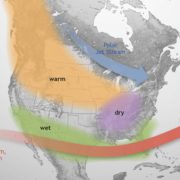
Next El Niño update in October

This discussion is a consolidated effort of the National Oceanic and Atmospheric Administration (NOAA), NOAA’s National Weather Service, and their funded institutions. Oceanic and atmospheric conditions are updated weekly on the Climate Prediction Center web site (El Niño/La Niña Current Conditions and Expert Discussions). Additional perspectives and analysis are also available in an ENSO blog. A probabilistic strength forecast is available here. The next ENSO Diagnostics Discussion is scheduled for 12 October 2023.

El Niño

El Niño is anticipated to continue through the Northern Hemisphere winter (with a greater than 95% chance through January – March 2024). An El Niño Advisory remains in effect. Graphic: NOAA

Full discussion on the latest El Niño update from the National Weather Service Climate Prediction Center: www.cpc.ncep.noaa.gov/products/analysis_monitoring/enso_advisory/ensodisc.shtml


El Niño is Coming This Winter. The Question is, Will It Be a Whopper?

San Diego County’s fragile shoreline and vulnerable beachfront properties could be in for a rough winter, according to the California Coastal Commission, the National Weather Service and some top San Diego scientists.

“We are looking at an emerging El Niño event,” staff geologist Joseph Street told the Coastal Commission at its meeting Wednesday in Eureka.