El Niño and La Niña are natural climate phenomena that alter weather patterns around the world. El Niño occurs irregularly but shows up roughly every three to seven years and typically lasts between nine and 12 months with occasional exceptions that linger for multiple years.
After three successive years of La Niña (2020-2023), the National Oceanic and Atmospheric Administration (NOAA) and the National Weather Service (NWS) have officially declared an El Niño event that is expected to continue and intensify into winter. As of this writing, the forecast predicts this year’s El Niño is likely to be of moderate strength and is unlikely to be as intense as the 2015-2016 event.
El Niño’s effects are powerful. Its ocean warming is enough to drive average global temperatures higher, and to temporarily raise sea levels along the California coast via thermal expansion – offering humanity a glimpse of conditions that are projected to become the norm in coming decades as climate change accelerates.
To learn more, we asked experts from UC San Diego’s Scripps Institution of Oceanography to answer some common questions about El Niño and its impacts.
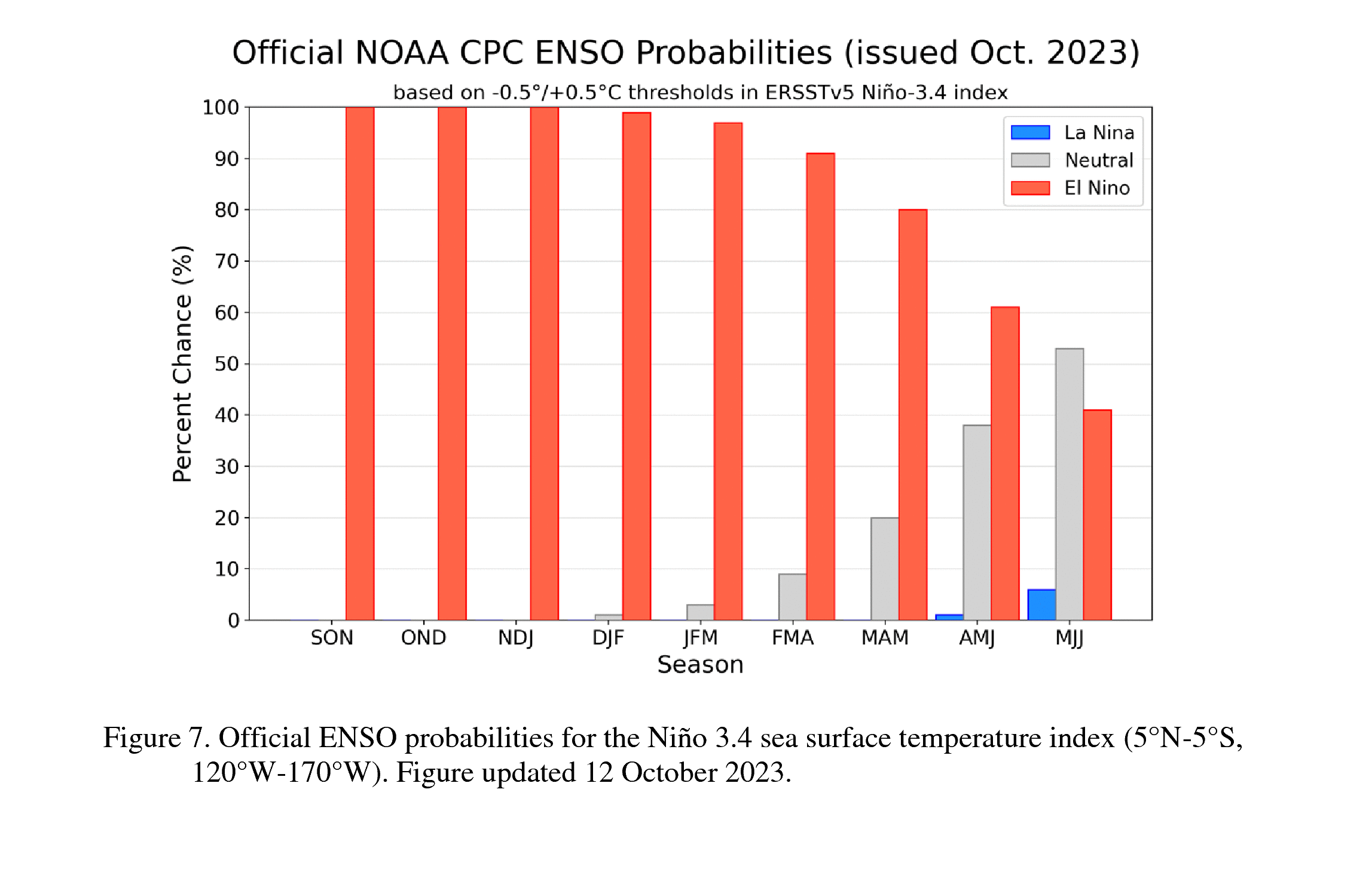
El Niño is anticipated to continue through the Northern Hemisphere spring (with an 80% chance during March-May 2024). An El Niño Advisory remains in effect. Graphic: NWS Climate Prediction Center
Scripps Oceanography experts explain phenomenon and its global impacts
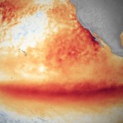
Shang-Ping Xie (Professor of Climate Science and Physical Oceanography, Roger Revelle Chair in Environmental Science): El Niño refers to anomalously warm waters in the central and eastern Pacific Ocean near the equator. La Niña is the opposite–colder than average water temperatures in the equatorial Pacific.
The tropics are like the engine room of the Pacific. Heat in the tropics drives global atmospheric circulation. In that sense, variations in the tropical Pacific like El Niño can have huge impacts on global weather patterns.
What causes El Niño?
Shang-Ping Xie: El Niño and La Niña are the result of complex interactions between the ocean and the atmosphere.
The trade winds that normally blow from east to west across the tropical Pacific relax in response to El Niño’s warmer water conditions. The trade winds normally push warm water from east to west in the tropical Pacific and cause cold, nutrient-rich water upwelling in the eastern equatorial Pacific. Without the trade winds, warm water builds up in the central and eastern equatorial Pacific.
Anomalously warm water can cause the trade winds to weaken but weaker trade winds can cause ocean warming. It’s somewhat of a chicken-egg problem: “Do we see the ocean side of El Niño or the atmospheric side first?” But really it’s a chicken-egg coupled problem, because the atmosphere and the ocean are in contact and influence each other.
Once an El Niño gets established these atmospheric and oceanic effects can reinforce each other.
How does El Niño typically alter Earth’s weather patterns?
Shang-Ping Xie: In a typical El Niño year, India’s monsoon rainfall from June to September will decrease and may cause drought conditions. The second stop would be around Australia and Indonesia. They’re also likely to get dry conditions, and perhaps wildfires during North America’s fall months.
Then the third stop would be North America. El Niño often causes California and the southwestern states to experience more storms and increased rainfall in the winter months. That said, every El Niño is different and you can have a dry El Niño winter just like you can have a wet La Niña winter the way we just did.
The fourth stop – if the El Niño grows in magnitude – is the Pacific coast of South America during North American springtime. Countries like Peru can get heavy rainfall. The final stop would be China and Japan. In that part of the world, research shows that the last echo of a typical El Niño is heavy rains and flooding along the Yangtze River in China and across Japan.
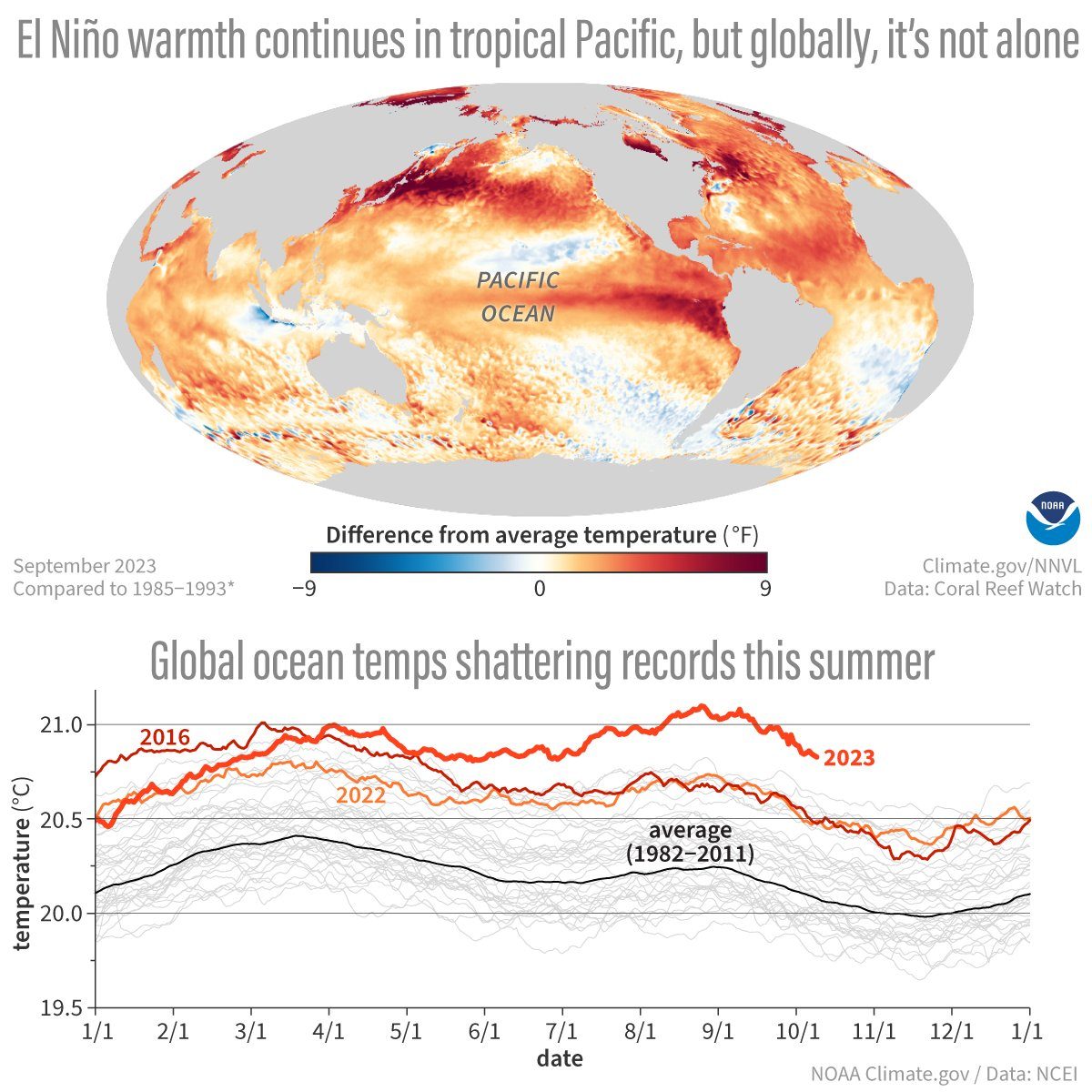
At the global scale, the ocean warming that occurs during an El Niño year is enough to drive average global temperatures higher by heating the atmosphere around the equator. Layering El Niño on top of warming due to human-caused climate change could push global temperatures to new highs, including past the Paris Agreement threshold of 1.5 degrees Celsius [2.7 degrees Fahrenheit] of warming above pre-industrial levels.
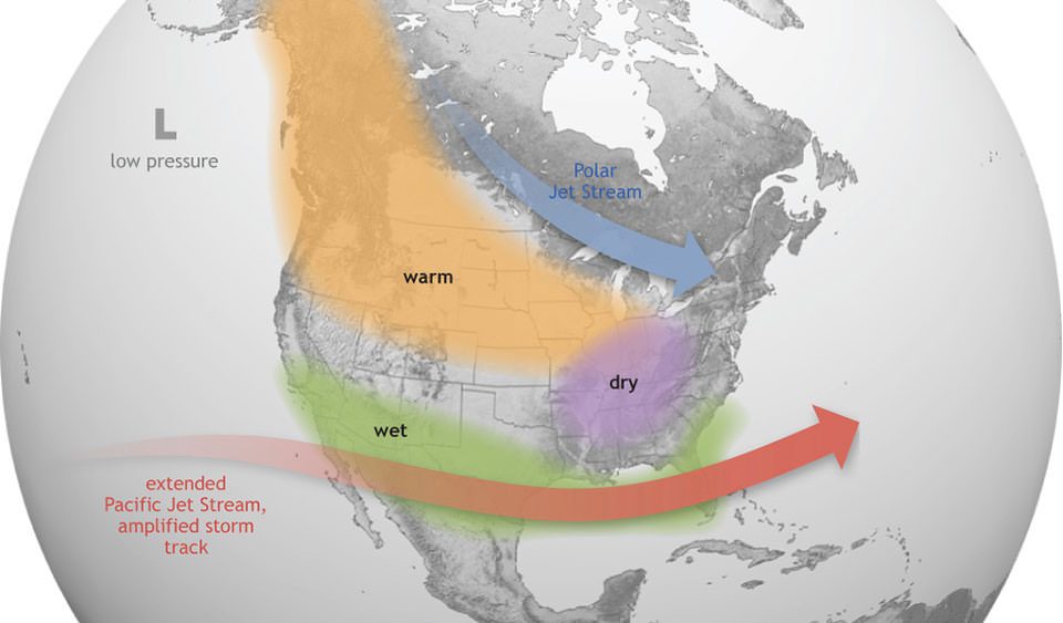
For California, especially Southern California, El Niño can typically mean larger storms in the winter which can mean more rainfall and larger waves along the coast. Graphic: NOAA
What can Californians expect from a typical El Niño year?
Dan Cayan (Climate Science Researcher): For California, the North Pacific storm track is often highly active during the winter months, and those storms can be shunted a bit farther southward, which can deliver a more direct hit to Southern California. So California, especially Southern California, can get larger storms in the winter which can mean more rainfall and larger waves along the coast. It can also be somewhat drier in the Pacific Northwest, with Northern California sort of being a fulcrum that can go either way.
Julie Kalansky (Climate scientist and deputy director for operations at the Center for Western Weather and Water Extremes): It’s important to stress that even though we see these general patterns during El Niño and La Niña years, there is still a lot of variability and not every event is going to follow the general pattern. Last year’s La Niña was a perfect example. We’d normally expect dry winter conditions from a La Niña in Southern California but it was wetter than normal. So, the declaration of an El Niño doesn’t guarantee that Southern California is going to have a wet, stormy winter, but it does stack the deck in that direction.
Laura Engeman (Coastal resilience specialist with the Center for Climate Change Impacts and Adaptation): Often during El Niño years California sees elevated sea levels. This is because El Ninos are associated with warmer sea surface waters in the equatorial eastern Pacific. When large swaths of the Pacific surface waters warm, there is a short-term thermal expansion of the ocean that raises sea levels along California’s coast. For example, in the 2015-2016 El Nino, California sea levels were elevated as much as 11 inches.
How does El Niño impact the California coast?
Adam Young (Integrative Oceanography Researcher): El Niño conditions can generate a triple threat for coastal hazards in California. Increased rainfall triggers landslides; powerful waves can accelerate erosion of beaches, sea cliffs, and bluffs, and cause coastal flooding; and strong El Niño conditions can raise sea level on the California coast by 15 to 30 centimeters (6-13 inches). Combined, these factors increase coastal erosion and flooding during El Niño events, which can threaten public parks, beaches, critical infrastructure, highways, and homes.
Some of what determines the severity of impacts is related to the timing of winter storms. For example, if large waves arrive during a very high tide, the potential for coastal flooding and other types of damage increases significantly. Multiple sequential storms can also be a factor. The first storm may strip all the sand off a beach, and without the natural sand buffer, the next storm can deliver a stronger punch. Every El Niño is different but these conditions increase the possibility for significant coastal impacts.
It’s important for us to monitor this year’s El Niño by mapping the coastline before and after the event so we can measure how the coast responds. The elevated sea levels associated with El Niño also provide a snapshot of how future sea level rise might impact our coast. Collecting these data is essential to improve our ability to predict hazards and plan for the future.
Can you blame individual weather events on El Niño?
Dan Cayan: It’s hard to directly attribute individual storms to a seasonal phenomenon. At the time scale of a season, if we get lots of storms and lots of precipitation I think it makes sense to at least partially attribute what happened with those storms to El Niño. But just like not all El Niño years follow the typical pattern, storms can also be atypical. So El Niño doesn’t dictate every storm but every storm is affected by El Niño. Individual weather patterns can be shifted or enhanced or reinforced by this seasonal phenomenon.
How do we detect El Niño?
Daniel Rudnick (Professor of Physical Oceanography): El Niños are detected using measurements from a combination of instruments including moored buoys, the Argo network of floats, and satellite measurements. Sea surface temperatures in the equatorial Pacific from those different sources are the measurements that NOAA uses to officially declare an El Niño.
Locally, I’ve been monitoring the effects of El Niño off California’s coast using underwater gliders since 2005. These autonomous gliders can cover about 15 miles underwater each day during a series of dives from the surface down to about 500 meters. This network of gliders gives us continuous measurements of temperature not just at the surface but at depth, as well as various other measurements related to oxygen concentration, salinity, and ocean currents. The glider data let us see how California’s waters are responding to changes caused by El Niño in real time. Taking all these measurements down to 500 meters helps screen out local factors that might only be altering conditions at the surface.
With the help of new funding from the Bipartisan Infrastructure Law and the Southern California Coastal Ocean Observing System, we are updating our fleet of gliders so they can go farther and carry more sensors. The new gliders will include sensors that detect nitrate, an important nutrient for phytoplankton, and pH, which will help us measure ocean acidification in local waters.
El Niño typically reduces the coastal upwelling that brings cold water full of nutrients like nitrate to the surface off California’s coast, and so having nitrate sensors on the gliders will help us to monitor the status of upwelling along the coast before, after, and during El Niño events.
How does El Niño impact marine ecosystems?
Mark Ohman (Professor of Biological Oceanography): There are different effects for different organisms, but El Niño often reduces coastal upwelling in the eastern Pacific, which is an important source of nutrients for the plankton at the base of the food web. So, the broadest impact is that overall biological productivity in the eastern Pacific tends to decrease.
At the same time, the warmer waters off the coast of North America can also lead to an influx of subtropical and tropical species of plankton and fish. In San Diego, we sometimes see major influxes of swimming red crabs (Pleuroncodes planipes) that normally breed off the coast of Baja. When I first came to Scripps, a marine technician told me about a guano index for El Niño. If the guano stains from the seabirds on the Scripps pier turned from white to pink to red this indicated there was a strong El Niño, because the birds were feasting on the red crabs that had come north from Baja waters.
Seabirds and marine mammals may also alter the timing of their migrations if their major food sources diminish because of reduced upwelling. Blue whales, for instance, usually migrate into Southern California waters between May and September and presumably they might delay their arrival if reduced upwelling meant less krill were available.
Colleen Petrik (Assistant Professor of Biological Oceanography): Warmer waters in the eastern Pacific can allow for big open ocean fish like tuna to expand their range closer to the California coast. This range expansion also occurs vertically in the water column. Normally, deeper waters that are high in nutrients can be low in oxygen. But when upwelling is reduced by El Niño, oxygen levels in the middle depths can increase which allows species like tuna that need a lot of oxygen to move into those depths and find more food. Tuna often do quite well during El Niño years because they can expand their range horizontally into the eastern Pacific and vertically into these deeper waters that normally don’t have enough oxygen.
Ed Parnell (Associate Researcher in Integrative Oceanography Division): El Niño can be devastating for giant kelp forests in Southern California and Baja. Reduced coastal upwelling means fewer nutrients to fuel kelp growth and the altered storm track can mean more violent waves that rip out kelp.
Some recovery occurs during these colder water periods of La Nina conditions, but there hasn’t been a full recovery and now another El Niño is coming that will damage the system again. The whole system is being stressed more frequently and harder.
Kelp forests provide vital food and habitat for lots of marine species. Giant kelp grows fast but when it gets ripped out various understory algae species can move in that then make it even harder for the kelp forest to come back.
I’m very worried that with the ocean warming we are seeing and the increased likelihood of severe and frequent El Niños, that much of Southern California’s kelp canopy could disappear within my kids’ lifetime.
Jennifer Smith (Professor of Marine Biology): The impacts of El Niño depend on the specific event – its severity and duration – but an increase in ocean temperatures is ubiquitous, and that can make coral bleaching more likely. Corals are susceptible to changes in temperature and they will bleach if temperatures go above a certain threshold for too long.
The 2015-2016 El Niño is a clear example of how severe and how widespread the impact on coral reefs can be. During that event we saw massive bleaching in Hawaii, Australia’s Great Barrier Reef, the Caribbean, and places like Fiji in the South Pacific.
I was in the Hawaiian Islands in early August and there was no sign of bleaching, but the predictions suggest warming will continue or accelerate into winter. My lab is keeping a close eye on it and we are definitely worried about potential impacts.
We are hoping these ecosystems are adapting over time and can maybe show more resilience in the future because these heat waves are such a strong selective pressure for heat tolerant individuals. But we don’t know. My lab is actively researching this – looking for corals with more thermal tolerance and hopefully one day using that information to help reefs survive.
Is climate change altering the frequency or intensity of El Niño events?
Shang-Ping Xie: The short answer is we don’t know. It’s the subject of an ongoing and intense debate. Right now the models are telling us different things. This means our physical understanding isn’t yet precise enough to pin down how El Niño changes in a warmer climate. Really, it tells us we need more research into El Niño.
(Editor’s Note: Story by Alex Fox, at UC San Diego Scripps Institution of Oceanography, from UC San Diego Today. The San Diego County Water Authority has partnered with the Scripps Institution of Oceanography at UC San Diego to better predict atmospheric rivers and improve water management before, during, and after those seasonal storms.)