After facing criticism, California water regulators have proposed new conservation rules that would ease requirements for urban suppliers and lead to smaller statewide water savings than originally planned.
https://www.waternewsnetwork.com/wp-content/uploads/2024/04/WNN-Horizontal-White-Blue2.png00Chelsea Camposhttps://www.waternewsnetwork.com/wp-content/uploads/2024/04/WNN-Horizontal-White-Blue2.pngChelsea Campos2024-03-13 10:09:552024-03-13 10:09:55California Eases New Water Saving Regulations for Local Agencies After Pushback
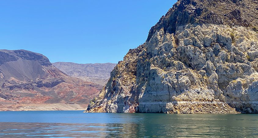
California, Arizona and Nevada on Wednesday offered what they described as significant concessions on how much Colorado River water they claim, as their counterparts nearer the river’s source proposed more modest changes that would protect their rights.
https://www.waternewsnetwork.com/wp-content/uploads/2024/04/WNN-Horizontal-White-Blue2.png00Maddie Simmonshttps://www.waternewsnetwork.com/wp-content/uploads/2024/04/WNN-Horizontal-White-Blue2.pngMaddie Simmons2024-03-07 08:16:482024-03-07 08:16:48California, Arizona, Nevada Join in Plan to Protect Colorado River Amid Climate Change
California water agencies including the San Diego County Water Authority are exploring ways to better manage sporadic periods of abundant rainfall — part of a larger effort to meet the ever-changing realities they face logistically and economically.
Water Authority General Manager Dan Denham recently discussed the evolution of regional water management on the Southern California Water Dialogue. The Water Dialogues are a monthly forum exploring water-related issues of regional interest.
The backdrop for the discussion is what many call “climate whiplash” — for instance, when three years of record drought from 2020 to 2022 were followed by abnormally high rainfall in 2023. In the future, California could experience shorter but more extreme wet seasons between periods of drought.
View the webinar here.
Creative portfolio approach to water management
At the Water Authority — the agency responsible for long-term water planning in San Diego County — Denham said the lack of regular rainfall and little access to groundwater has forced the Water Authority to be more creative than most water agencies in securing a safe, reliable water supply.
“We embarked upon a 20-to-30-year process to diversify the Water Authority’s supply portfolio. Our board directed a portfolio approach to ensure that we had not only sufficient supplies but also made significant investments in infrastructure,” explained Denham.
“We’ve adopted cutting-edge conservation and techniques. We’ve sponsored legislation at the state level. And we’re at the forefront of many water use efficiency programs,” said Denham.
With those investments and actions as the foundation, the time is right to set a vision for the coming decades. “The future of water in Southern California — of course, reuse is going to be a big component of it — but I do believe a lot of it is going to be sharing resources and developing partnerships,” Denham said.
Advancing long-term water-sharing partnerships
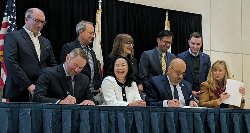
Signing the historic agreement: Top (L to R): Mel Katz, chair SDCWA Board; Jim Madaffer, Vice Chair Colorado River Board of CA and SDCWA Board member; Gloria Cordero, MWD’s representative to the Colorado River Board; Adan Ortega, chair MWD Board; J.B. Hamby, Chair Colorado River Board of CA. Bottom (L To R): Dan Denham, SDCWA General Manager; Camille Touton, Commissioner of the U.S. Bureau of Reclamation; Adel Hagekhalil, MWD General Manager; Jamie Asbury, Imperial Irrigation District General Manager. Photo: San Diego County Water Authority
Denham said investing in a long-term partnership with the Imperial Irrigation District in a water conservation agreement has proved key. “Those types of partnerships have continued and had been successful over the past 20 years,” said Denham.
“This is what our diversification looks like. This is 25 years’ worth of investment in resiliency, transitioning us from an imported water agency with one source of supply to where we’re at today with a really diverse resource mix,” said Denham.
Denham says in addition to maximizing reuse, sharing resources and developing partnerships to share those resources will become vital. The Water Authority signed a landmark agreement with the Metropolitan Water District and the Imperial Irrigation District in late 2023.
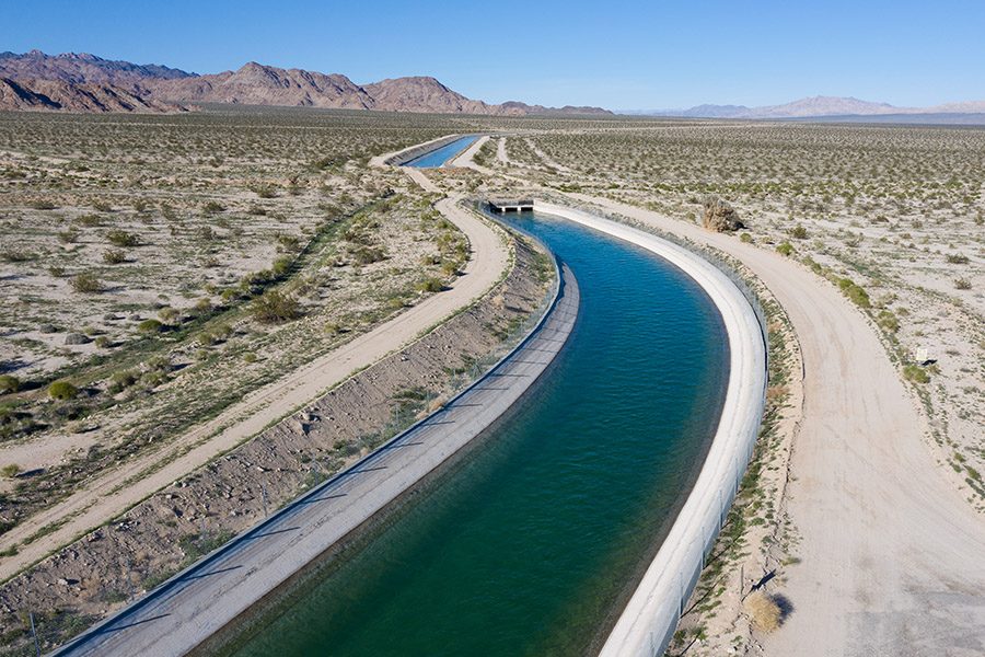
“What we were able to do was take advantage of those high runoff years in Northern California, bringing that State Water Project water down to San Diego and leaving some of our Colorado River conserved water in Lake Mead – 50,000-acre feet – which raised the reservoir by six inches. It could not have been done without the partnership that we have in relationships developed over time with the Metropolitan Water District and the Imperial Irrigation District. I look towards more of this to the future,” said Denham.
Flexibility to optimize water resources
In October 2003, the San Diego County Water Authority, Coachella Valley Water District, Imperial Irrigation District, Metropolitan Water District of Southern California, State of California and U.S. Department of the Interior completed a historic set of agreements to conserve and transfer Colorado River water.
While planning for drought is necessary, it’s also necessary to devise a plan flexible enough to take advantage of high-runoff years.
“What do you do in those high runoff years, in those years of abundance? Some of that speaks to storage,” explained Denham. “The Water Authority has increased its largest surface water storage reservoir. It’s doubled in size. But the Water Authority — like others in the Metropolitan Water District service area in California, is realizing that those surface water storage reservoirs are pretty full.
“What does that speak to next? Flexibility, and the sharing of resources. If our reservoirs are full, or we don’t have the demands for the investments that we’ve made, whether it’s in the Colorado River supplies or the Carlsbad desalination plant, perhaps there’s another partner in Southern California or in the Lower Colorado River Basin that we can exchange supplies with.
“What I mean by that is we do have supplies that can be managed in a different way,” said Denham.
Established in 1998, the Water Dialogue explores the common interests among Southern California water agencies, environmental organizations, and public interest organizations, and serves as a clearinghouse and advocate for projects, activities, and processes that will improve the quality and reliability of Southern California’s water supply.
The Water Dialogue represents members including the Metropolitan Water District of Southern California, Southern California Watershed Alliance, Sierra Club, West Basin Municipal Water District, Central Basin Municipal Water District, Inland Empire Utilities Agency, Irvine Ranch Water District, Trabuco Canyon Water District, Southern California Water Coalition, Atwater Consulting Group, Jacobs and Caltech/JPL/NASA.
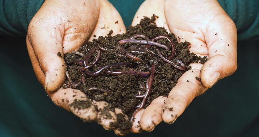
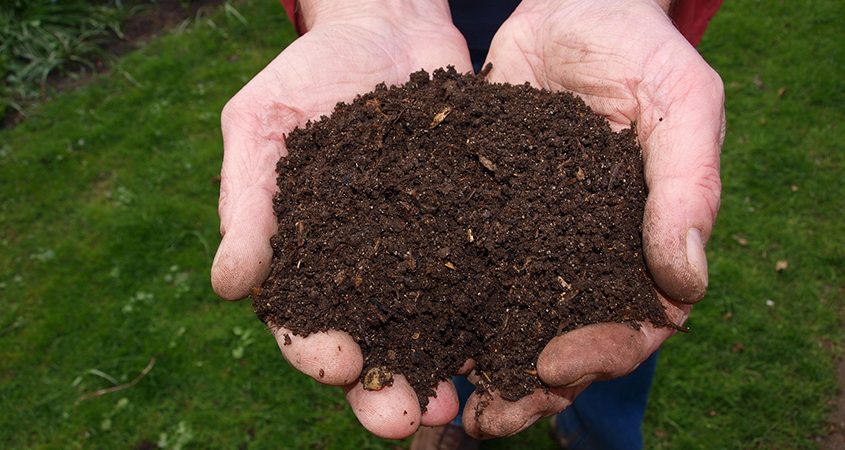
One of the most valuable tools for managing water retention and avoiding stormwater runoff while improving your landscaping soil harnesses the power of worms – earthworks, to be specific.
Vermiculture and vermicomposting are eco-friendly tools using earthworms to transform organic waste into nutrient-rich compost. This process benefits gardeners and the environment.
In the San Diego region, spring’s mild weather is an ideal time to start vermicomposting. Moderate temperatures facilitate optimal worm activity and compost processing. During the hotter summer months, compost bins must be kept in cooler, shaded areas to prevent overheating and ensure worm survival.
Vallecitos Water District 2023 Landscape Contest winner Dean Williams of Carlsbad is a big believer in vermiculture and vermicomposting. In this video, he shows how easy it is to learn how to put worms to work in your landscaping.
Understanding Vermiculture and Vermicomposting
Vermiculture refers to the cultivation of earthworms. The normal activity of earthworms breaks down organic waste. The result is vermicompost, also known as worm castings, a highly nutritious form of compost.
Vermicomposting is the practice of using earthworms to convert organic wastes into high-quality compost and worm castings. This method is an efficient, odorless, and space-saving way to recycle kitchen scraps, keeping them out of landfills where they contribute to greenhouse gas emissions and climate change.
How Using Worms Works
Adding common kitchen food waste to your vermicomposting system keeps it out of our landfills where it produces greenhouse gases. Photo: Sarah Chai/Pexels
As the video shows, setting up a vermicomposting bin is simple and can be done indoors or outdoors. The bin is stocked with material such as shredded newspaper, cardboard, or coconut coir and stocked with earthworms. When organic waste is added, such as food scraps, weeds, or plant trimmings, the worms digest this material and convert it into compost.
Recommended types of worms for vermicomposting are red wigglers (Eisenia fetida) and red earthworms (Lumbricus rubellus). Both thrive in compost bins and are efficient at processing waste.
Vermicomposting’s Environmental Benefits
Nutrient-rich compost produced by vermiculture helps soil retain rainwater in your garden, preventing it from picking up pollutants and washing them into storm drains. Photo: Pixabay/CC
Vermicomposting helps protect the watershed and preserves soil in several ways.
Safe, Nutrient-Rich Soil Amendment: Vermicompost improves soil structure and enhances nutrient availability. It can reduce the need for chemical fertilizers.
Water Conservation: By improving soil structure and water retention, vermicompost helps conserve water.
Stormwater Runoff: Healthy, vermicompost-amended soils absorb water more efficiently. It lessens the amount of runoff washing pollutants into watersheds.
Waste Reduction: Vermicomposting diverts organic waste from landfills, helping avoid the production and release of greenhouse gases.
As vermicompost increases the ground’s capacity to absorb rainwater, it lessens the burden on stormwater management systems. With less water flowing into stormwater drainage systems, vermiculture helps diminish flood risks.
Vermiculture and vermicomposting offer a holistic approach to environmental stewardship for San Diego residents. It’s an easy, practical way for individuals to help preserve resources, enhance soil health, and support sustainable gardening. Vermiculture and vermicomposting offer simple tools to confront the challenges of climate change, including risks to our region’s long-term water supply.
For decades, Southern California’s infrastructure has driven economic growth, enabling the swift movement of goods throughout the region, enhancing health and safety across communities, and improving the quality of life for residents.
https://www.waternewsnetwork.com/wp-content/uploads/2024/04/WNN-Horizontal-White-Blue2.png00Maddie Simmonshttps://www.waternewsnetwork.com/wp-content/uploads/2024/04/WNN-Horizontal-White-Blue2.pngMaddie Simmons2024-02-15 08:13:142024-02-15 08:13:14The High Cost of Underinvestment
John Kennedy watched in frustration Tuesday as floodwaters pulsed through the Santa Ana River, past systems the Orange County, Calif., water manager uses to capture precious water and send it underground. For a second consecutive winter, rain is not just falling on once-parched California — it’s inundating the Golden State in record-setting volume, faster than it can be saved.
New Mexico is teaming up with Google to hunt for leaky water pipes using satellite imagery as the drought-stricken state prepares for a future in which growing demand puts more pressure on already dwindling drinking water supplies.
https://www.waternewsnetwork.com/wp-content/uploads/2024/04/WNN-Horizontal-White-Blue2.png00Maddie Simmonshttps://www.waternewsnetwork.com/wp-content/uploads/2024/04/WNN-Horizontal-White-Blue2.pngMaddie Simmons2024-01-31 08:20:022024-01-31 08:20:02Spring A Leak? Google Will Find it Through a New Partnership Aimed at Saving Water in New Mexico
For the second time in a month, torrential flooding returned to Southern California this week with El Niño-fueled rains rolling in off the Pacific Ocean. This time San Diego felt the punch. The city, known for weather “the closest thing to perfect in America,” experienced one of its wettest days on record.
https://www.waternewsnetwork.com/wp-content/uploads/2024/04/WNN-Horizontal-White-Blue2.png00Maddie Simmonshttps://www.waternewsnetwork.com/wp-content/uploads/2024/04/WNN-Horizontal-White-Blue2.pngMaddie Simmons2024-01-26 08:37:242024-01-26 08:37:24Dry, Sunny San Diego Was Hit With Damaging Floods. What’s Going On? Is It Climate Change?
River basins around the world that were once regularly snowbound are increasingly seeing their snowpack shrink and climate change is to blame, a new study found. “Many of the world’s most populous basins are hovering on the precipice of rapid snow declines,” concluded the study of snow amounts since 1981 in Wednesday’s journal Nature.
https://www.waternewsnetwork.com/wp-content/uploads/2024/04/WNN-Horizontal-White-Blue2.png00Maddie Simmonshttps://www.waternewsnetwork.com/wp-content/uploads/2024/04/WNN-Horizontal-White-Blue2.pngMaddie Simmons2024-01-11 08:29:292024-01-11 08:29:29Climate Change Is Shrinking Snowpack In Many Places, Study Shows. And It Will Get Worse
This summer, when the temperature hit 110 degrees Fahrenheit or above in Phoenix for 31 straight days, many were fretting about the Southwest’s prospects in the age of climate change. A writer for The Atlantic asked, “When Will the Southwest Become Unlivable?” Bloomberg wondered, “How Long Can We Keep Living in Hotboxes Like Phoenix?”
https://www.waternewsnetwork.com/wp-content/uploads/2024/04/WNN-Horizontal-White-Blue2.png00Maddie Simmonshttps://www.waternewsnetwork.com/wp-content/uploads/2024/04/WNN-Horizontal-White-Blue2.pngMaddie Simmons2024-01-02 08:16:422024-01-02 08:16:42OPINION -Don’t Flee the American Southwest Just Yet