Tag Archive for: Climate Change
Hundreds Of Hazardous Sites in California Are At Risk Of Flooding As Sea Level Rises, Study Finds
Hundreds of hazardous industrial sites that dot the California coastline – including oil and gas refineries and sewage-treatment plants – are at risk of severe flooding from rising sea levels if the climate crisis worsens, new research shows.
If planet-warming pollution continues to rise unabated, 129 industrial sites are estimated to be at risk of coastal flooding by 2050 according to the study, published Tuesday in the journal Environmental Science & Technology by researchers from University of California at Los Angeles and Berkeley, as well as Climate Central.
Snow Surveys Help Plan Snowmelt Runoff Forecasts
The California Department of Water Resources May 1 conducted the fifth snow survey of the season at Phillips Station. The manual survey recorded 59 inches of snow depth and a snow water equivalent of 30 inches, which is 241% of average for this location on May 1. The last time there was measurable snow at the Phillips snow course on May 1 was 2020, when only 1.5 inches of snow and .5 inches of snow water equivalent was measured
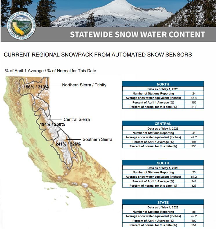
DWR’s electronic readings from 130 snow sensors placed throughout the state indicate the statewide snowpack’s snow water equivalent is 49.2 inches, or 254% of average for May 1.
The snow water equivalent measures the amount of water still contained in the snowpack and is a key component of DWR’s water supply run-off forecast.
“While providing a significant boost to California’s water supplies, this year’s massive snowpack is posing continued flood risks in the San Joaquin Valley,” said DWR Director Karla Nemeth. “The snowpack will not disappear in one week or one month but will lead to sustained high flows across the San Joaquin and Tulare Basins over the next several months and this data will help us inform water managers and ultimately help protect communities in these regions.”

Snowmelt runoff forecasts
Snow surveys like the one at Phillips Station are critical to planning for impacts of the coming snowmelt runoff on communities. DWR uses the most updated technology to gather data from snow surveys, a network of 130 remote snow sensors, and airborne snow observatory data to gather information on current real-world conditions to create the most accurate snowmelt runoff forecasts possible. These runoff forecasts, published through DWR’s Bulletin 120, allow reservoir operators to plan for anticipated inflows and water managers downstream of reservoirs to plan and prepare for flood risks.
Despite a brief increase in temperatures in late April, the statewide snowpack overall melted at a slower pace than average over the month of April due to below average temperatures early in the month and increased cloud cover. An average of 12 inches of the snowpack’s snow water equivalent has melted in the past month and it now contains an average of 49.2 inches.
“The snowpack will not disappear in one week or one month but will lead to sustained high flows across the San Joaquin and Tulare Basins over the next several months… pic.twitter.com/zIOiGMm0I7
— CA – DWR (@CA_DWR) May 1, 2023
Water supply, flood control planning
“No matter how you look at the data, only a handful of years in the historical record compared to this year’s results,” said Sean de Guzman, manager of DWR’s Snow Surveys and Water Supply Forecasting Unit. “Survey results from our partners in the California Cooperative Snow Surveys Program and other data, including data from Airborne Snow Observatory flights, allow us to incorporate these data into our models to provide the most accurate snowmelt runoff forecasts possible right now to inform water supply, flood control, and planning.”
@CA_DWR uses data from the 5/1 snow survey as well as ASO aircraft-based LiDAR & remote snow sensors to forecast & supply current conditions of the snowpack in real-time & provide water managers, #flood agencies & emergency responders the most accurate snowmelt forecasts possible pic.twitter.com/dsuRxt1ORJ
— CA – DWR (@CA_DWR) May 1, 2023
Climate Change and snowpack averages
According to historical records, only the April 1 measurements from the years 1952, 1969, 1983 and this year were above 200 percent, although it is difficult to directly compare individual years across the decades due to changes in the number of snow courses measured over time.
Due to the impact of climate change on California’s snowpack, since 2021, snowpack averages have been calculated using a timeframe of 1991 through 2020 so that results better reflect the current climate conditions.
DWR is maximizing the amount of water that can be stored and diverted from this record snowpack.
In April, DWR announced a 100% allocation of requested supplies from the State Water Project, which delivers water to 29 public water agencies that serve 27 million Californians and 750,000 acres of farmland. The last time the SWP allocated 100% was in 2006. DWR is also maximizing the amount of water that can be diverted towards recharging groundwater basins so more water is stored for future use in underground reservoirs.

Flooding impacts in California
Last week, Governor Newsom visited the Tulare Basin to tour flood impacts first hand, met with community leaders and emphasized the state’s commitment to supporting and providing appropriate assistance to counties impacted by recent and anticipated flooding this spring and summer.
Snowmelt runoff forecasts are an instrumental part of the assistance provided by DWR’s State-Federal Flood Operations Center (FOC), which is supporting emergency response in the Tulare Lake Basin and Lower San Joaquin River by providing technical and materials assistance to support ongoing flood response activities.
Storms this year have caused impacts across the state including flooding in the community of Pajaro and communities in Sacramento, Tulare, and Merced counties. The FOC has helped Californians by providing more than 1.4 million sandbags, 1 million square feet of plastic sheeting, and 9,000 feet of reinforcing muscle wall, across the state since January.
May Drought Outlook by @NOAA’s @NWSCPC
Some potential improvement in the drought-stricken Southern Plains. Also the East, Gulf Coast, and a bit of CA/NV.
Drought may develop on the Eastern Plains and Midwest including part of KS, NE, IA, MO, and IL.
Otherwise, drought persists pic.twitter.com/OfVbjzpMbh
— NIDIS Drought.gov (@DroughtGov) May 1, 2023
(Editor’s Note: Information in this story was provided by the California Department of Water Resources).
Long Beach Looks to Invest More in Groundwater as Colorado River Shrinks
With the future of the Colorado River and the amount of water it will be able to deliver to Southern California in question, the Long Beach Utilities Department is looking at investing $157 million into its groundwater system, which could reduce the city’s reliance on expensive and diminishing imported water.
Groundwater accounts for about 60% of the water that Long Beach residents use each year, and the Colorado provides about 25% of the city’s supply, with the rest coming from the State Water Project, both of which can fluctuate with precipitation patterns.
Colorado Leaders Are Rallying Against a Railway Project That Would Carry Crude Oil Along the Colorado River
A railway project in Eastern Utah is drawing significant pushback in Colorado as elected officials voice concerns about crude oil risks to the Colorado River, which is the West’s primary freshwater river.
The Uinta Basin Railway project would build around 80 miles of train tracks connecting oil production to America’s rail network.
‘We Can’t Be Living in an Economy of 40 Million People This Close to the Edge.’
Lake Mead, in Arizona and Nevada, is the largest reservoir in the United States and part of the Colorado River system, which supplies water to seven U.S. states and part of Mexico, including one third of the water used in Southern California. It also supplies 30 Tribal Nations.
At the end of last year, experts predicted that, due to drought and heavy demand for water, Lake Mead was just two years shy of dead pool, when water levels drop below the point at which it can flow downstream of the reservoir.
The Very Bad Math Behind the Colorado River Crisis
California and Arizona are currently fighting each other over water from the Colorado River. But this isn’t new — it’s actually been going on for over 100 years. At one point, the states literally went to war about it. The problem comes down to some really bad math from 1922.
Lawmakers Propose $4.5B Flood Protection Bond Measure
Californians could be voting on a major flood protection bond next November.
State lawmakers are pushing a $4.5 billion bond measure which would help fund water infrastructure projects across the state.
Land of Fire and Flood: How the Climate Crisis is Challenging Our Water Supply
Mark Pestrella is the director of L.A. County Public Works, which oversees 27 spreading grounds and 14 dams that both hold most of our local water supply as well as prevent massive flooding in the cities below.
Pestrella said he isn’t losing sleep over a megaflood. His biggest concern? The increasing severity of smaller, but intense storms — like many we experienced this winter.
Opinion: Future of California at Risk the Longer Landmark CEQA Environmental Law Remains Unchanged
Like our changing climate and its many impacts on our communities, economy and environment; like the collapse of critical infrastructure; like the humanitarian homelessness crisis on our streets and the housing shortage driving it; like so many other slow-motion disasters that have befallen us, the warning signs have been unmistakably clear.


