Tag Archive for: Center For Western Weather and Water Extremes

Scripps, CW3E and Yuba Water Agency Launched Weather Balloons During Atmospheric River

On Sunday morning, during the atmospheric river event in Northern California, scientists from the Center for Western Weather and Water Extremes (CW3E) at the Scripps Institute of Oceanography at UC San Diego and their partners at Yuba Water Agency launched weather balloons to gather data on the AR and its impacts on reservoirs.

Atmospheric River events in Water Year 2021

(Editor’s Note: The Center for Western Weather and Water Extremes, or CW3E, at Scripps Institution of Oceanography, released its report October 11 on atmospheric rivers during Water Year 2021.

Atmospheric Rivers-CW3E-Scripps-YubaNet-Science-drought

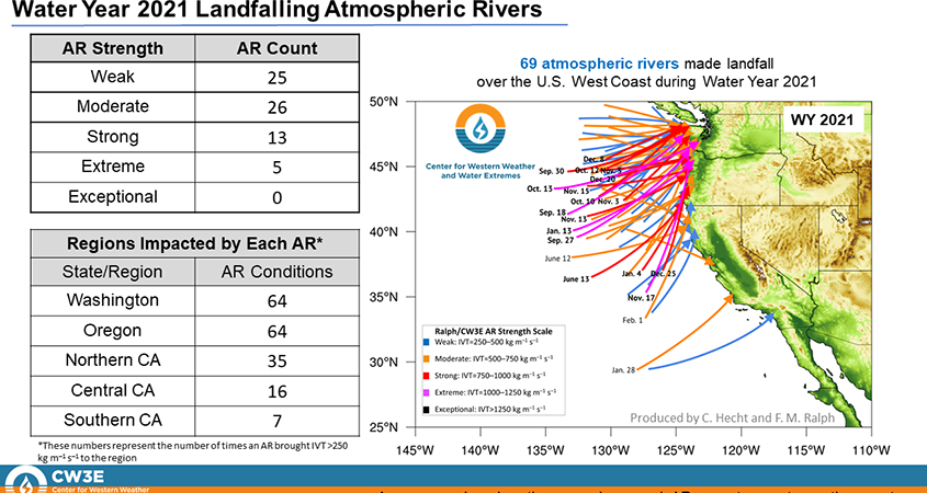
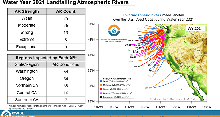
Distribution of Landfalling Atmospheric Rivers over the U.S. West Coast During Water Year 2021: End of Water Year Summary. Graphic: Center for Western Weather and Water Extremes

The San Diego County Water Authority partnered with the Scripps Institution of OceanographyCenter for Western Weather and Water Extremes, at UC San Diego in 2020 to better predict atmospheric rivers and improve water management before, during, and after those seasonal storms. The Center and its partners share best practices in forecast-informed reservoir operations, increased research around atmospheric rivers and droughts, and develop strategies for mitigating flood risk and increasing water supply reliability.)

Atmospheric Rivers-Water Year 2021-drought-climate

Atmospheric Rivers Left California Mostly Dry in Water Year 2021

The Center for Western Weather and Water Extremes, or CW3E, at Scripps Institution of Oceanography, released its report October 11 on atmospheric rivers during Water Year 2021.

The report, “Distribution of Landfalling Atmospheric Rivers over the U.S. West Coast During Water Year 2021: End of Water Year Summary” shows that more atmospheric rivers landed on the U.S. West Coast in Water Year 2021 than in Water Year 2020. But the majority of those storms reached the Pacific Northwest, not California, where drought conditions have impacted water supply.

“The report on atmospheric rivers shows the variability in weather across the state from year to year,” said Jeff Stephenson, Water Resources Manager with the San Diego County Water Authority. “Through our partnership with CW3E and the AR forecasting tools they’ve developed, it better prepares us in management of our water resources using regional storage. This storage, in conjunction with developing multiple water supply sources in the San Diego region, has prepared us for years when rainfall levels are below normal in the region.”

The summary report from CW3E

Water Year 2021 experienced a total of 69 landfalling ARs over the U.S. West Coast, 4 more than Water Year 2020.
• While WY 2021 experienced more ARs, a much larger majority of the ARs only impacted the Pacific Northwest.
• California only experienced AR conditions (IVT >250 kg m–1 s–1) from 36 separate ARs during WY 2021, compared to 43
during WY 2020.
Atmospheric Rivers-Water Year 2021-drought-climate

Distribution of Landfalling Atmospheric Rivers over the U.S. West Coast During Water Year 2021: End of Water Year Summary. Graphic: Center for Western Weather and Water Extremes

Fewer Atmospheric Rivers in California

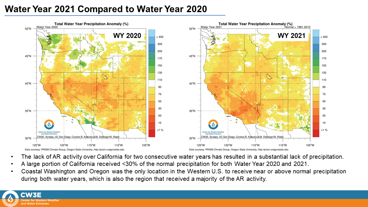
The lack of AR activity over California for two consecutive water years has resulted in a substantial lack of precipitation.
• A large portion of California received <30% of the normal precipitation for both Water Year 2020 and 2021.
• Coastal Washington and Oregon was the only location in the Western U.S. to receive near or above normal precipitation
during both water years, which is also the region that received a majority of the AR activity.

California experienced strong or greater magnitude AR conditions only three times during WY 2020 and 2021 combined

Atmospheric Rivers-CW3E-drought-climate

Atmospheric Rivers-CW3E-drought

The San Diego County Water Authority partnered with the Scripps Institution of Oceanography, Center for Western Weather and Water Extremes, at UC San Diego in 2020 to better predict atmospheric rivers and improve water management before, during, and after those seasonal storms. The Center and its partners share best practices in forecast-informed reservoir operations, increased research around atmospheric rivers and droughts, and develop strategies for mitigating flood risk and increasing water supply reliability.

For additional details and graphics go to: https://bit.ly/3mKhkcR
Water Year 2021 Characterized by Persistent Dry Weather and Worsening Drought in California

• Total precipitation has been well below normal throughout much of California during water year (WY) 2021
• In some regions, drier than normal conditions extend back to the start of WY 2020
• Drought has expanded and intensified across the state, and current water storage levels are below normal in many
reservoirs
• Below-normal snowpack in the Sierra Nevada may limit water resource availability as summer approaches
• The abnormally dry conditions were driven by a lack of landfalling atmospheric rivers (ARs) and persistent
ridging/blocking over the Northeast Pacific Ocean
• Drought is expected to continue through spring 2021, thereby increasing the threat of significant wildfire activity in
summer 2021

Landfalling Atmospheric Rivers Increase in First Quarter of Water Year 2021 Over 2020

A Scripps Center for Western Weather and Water Extremes report shows that more atmospheric rivers have made landfall over the U.S. West Coast in the first four months of Water Year 2021 compared to the previous period in 2020.

Atmospheric Rivers-CW3E-Scripps-Rain

Landfalling Atmospheric Rivers Increase in First Quarter of Water Year 2021 Over 2020

A Scripps Center for Western Weather and Water Extremes report shows that more atmospheric rivers have made landfall over the U.S. West Coast in the first four months of Water Year 2021 compared to the previous period in 2020.

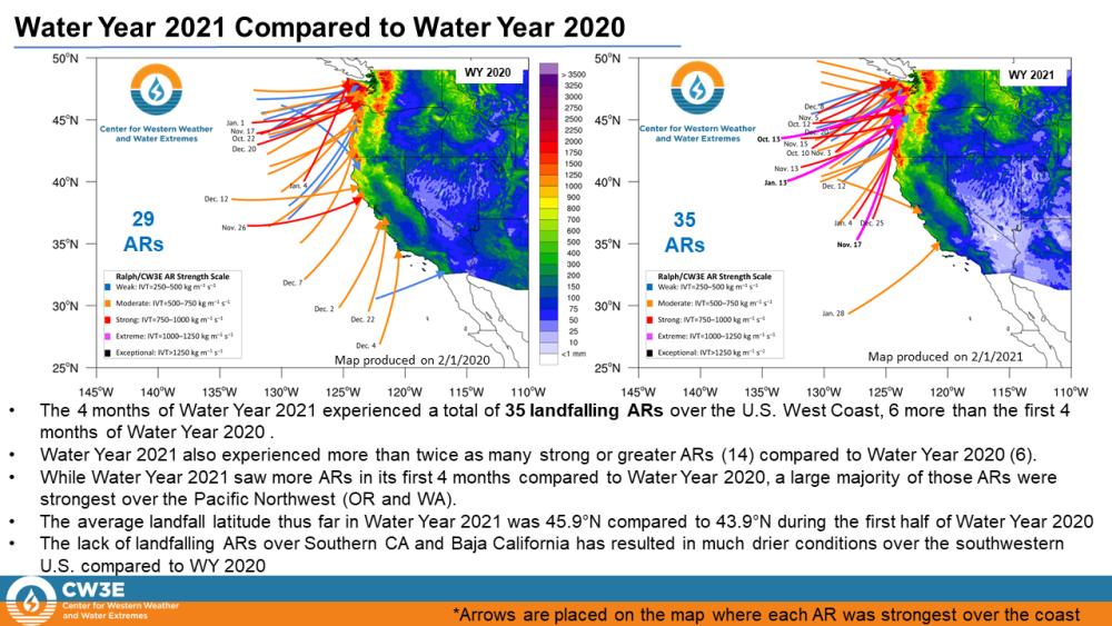
The four months of Water Year 2021 experienced a total of 35 landfalling ARs over the U.S. West Coast, six more than the first four months of Water Year 2020, according to the CW3E quarter year summary released February 11.

Key takeaways from the CW3E update on atmospheric rivers

• The first four months of Water Year 2021 experienced a total of 35 landfalling ARs over the U.S. West Coast, 6 more than the first four months of Water Year 2020.
• Water Year 2021 also experienced more than twice as many strong or greater ARs (14) compared to Water Year 2020 (6).
• While Water Year 2021 saw more ARs in its first 4 months compared to Water Year 2020, a large majority of those ARs were
strongest over the Pacific Northwest (Oregon and Washington).
• The average landfall latitude thus far in Water Year 2021 was 45.9°N compared to 43.9°N during the first half of Water Year 2020.
• The lack of landfalling ARs over Southern California and Baja California has resulted in much drier conditions over the southwestern U.S. compared to WY 2020.

CW3E-Atmospheric Rivers-Water Year 2021

The four months of Water Year 2021 experienced a total of 35 landfalling ARs over the U.S. West Coast, six more than the first four months of Water Year 2020. Graphic: Center for Western Weather and Water Extremes

Distribution of Landfalling Atmospheric Rivers over the U.S. West Coast During Water Year 2021: Quarter Year Summary

Atmospheric River-NOAA-WNN-CW3E

A partnership with the San Diego County Water Authority and the Scripps Institution of Oceanography at UC San Diego seeks to optimize water management to better predict atmospheric rivers before, during, and after those seasonal storms.

In August 2020, Scripps Center for Western Weather and Water Extremes (CW3E) launched the Water Affiliates Group, which brings together cutting-edge science and hands-on water industry experience to enhance reservoir operations in light of the changing climate. The Water Authority has a long-running alliance with Scripps and is among six founding water agencies statewide.

CW3E and its partners will share and support best practices in forecast-informed reservoir operations, increase research around atmospheric rivers and droughts, and develop strategies for mitigating flood risk and increasing water supply reliability.

Atmospheric Rivers-CW3E-water supply

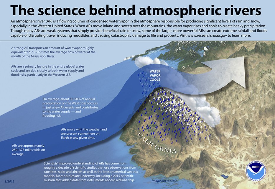
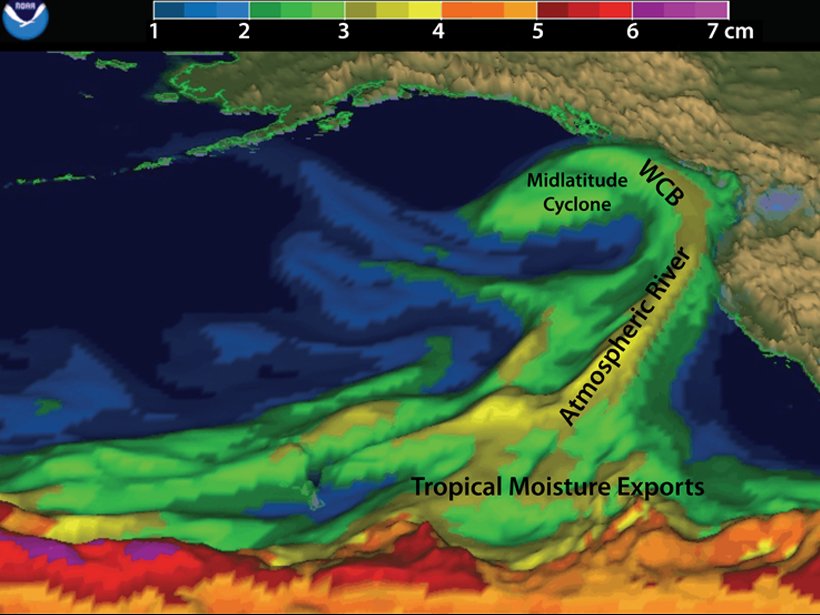
The above image, from the EOS article, is a depiction of an atmospheric river, interacting with West Coast mountains and a midlatitude cyclone over the northeast Pacific on 5 February 2015. This image provides an example of approximate locations of associated tropical moisture exports and a warm conveyor belt (WCB). Graphic: Adapted from NOAA/ESRL Physical Sciences Division via CW3E

As Fires Rage, California Center Aims to Better Understand Their Remedy: Atmospheric Rivers

At the Center for Western Weather and Water Extremes, researchers feel the urgency as they examine connections between West Coast precipitation and a devastating wildfire season, which has yet to conclude.

The center, part of Scripps Institution of Oceanography in La Jolla, Calif., has unlocked many secrets of atmospheric rivers — airborne jets of tropical moisture that can break droughts and quell fires but also unleash raging floodwaters.

Odds Of Reaching 100% Of Normal Water Year Precipitation

Drought status is often represented by maps of how much precipitation has fallen in the year to date, or how that amount differs from normal amounts of precipitation to date. Up-to-date examples of such maps are presented below:

A somewhat different viewpoint on the development of drought considers how much precipitation has fallen (or not) and how much is likely to fall in coming months, based on climatology. The following are maps of this and previous years’ drought development that explicitly takes both of these aspects into account.