Reclamation Announces 2024 Operating Conditions for Lake Powell and Lake Mead
The Bureau of Reclamation on August 15, released the Colorado River Basin August 2023 24-Month Study, which determines the tiers for the coordinated operation of Lake Powell and Lake Mead for 2024. These operating conditions, which are based on existing agreements under the 2007 guidelines and lower basin Drought Contingency Plans, will be in effect until the near-term guidelines from the Supplemental Environmental Impact Statement (SEIS) are finalized. Reclamation is currently analyzing the consensus-based Lower Division States proposed alternative for the SEIS.
Based on projections in the 24-Month Study, Lake Powell will operate in a Mid-Elevation Release Tier with a 7.48 million acre-feet release in water year 2024. Consistent with existing agreements, Lake Mead will operate in a Level 1 Shortage Condition – an improvement from the Level 2 Shortage Condition announced last year – with required shortages by Arizona and Nevada, coupled with Lower Basin Drought Contingency Plan water savings contributions. Mexico’s water delivery will be reduced consistent with Minute 323.
Lake Mead’s release in 2023 is projected to be the lowest in 30 years, approximately one and half million acre-feet lower than an average normal year, reflecting extensive, ongoing conservation efforts in the Lower Basin states funded in part by President Biden’s historic Investing in America agenda, above-normal inflows in the lower basin below Hoover Dam, and conservation in Mexico.
Reclamation: Significant improvement for Lake Mead due to improved hydrology, ongoing conservation efforts. Operating guidelines in effect until Reclamation finalizes SEIS, including analysis of consensus-based state conservation agreement.
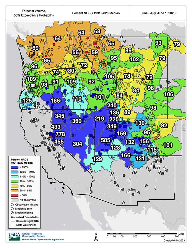
Investments in system conservation and improved hydrology this year have provided an opportunity to recover some reservoir storage. At the same time, the Colorado River system continues to face low elevations, with Lake Powell and Lake Mead at a combined storage of 36%.
“The above-average precipitation this year was a welcome relief, and coupled with our hard work for system conservation, we have the time to focus on the long-term sustainability solutions needed in the Colorado River Basin. However, Lake Powell and Lake Mead – the two largest reservoirs in the United States and the two largest storage units in the Colorado River system – remain at historically low levels,” said Reclamation Commissioner Camille Calimlim Touton. “As we experience a warmer, drier west due to a prolonged drought, accelerated by climate change, Reclamation is committed to leading inclusive and transparent efforts to develop the next-generation framework for managing the river system.”
Reclamation on Development of Near- and Long-Term Guidelines
Reclamation is simultaneously developing both near- and long-term guidelines for Lake Powell and Lake Mead operations. The supplemental SEIS in progress focuses on near-term actions, which would be applicable from 2024 through 2026 based on potential changes to limited sections of the 2007 Interim Guidelines. Reclamation temporarily withdrew the SEIS so it could fully analyze the consensus-based Lower Division States proposed alternative and will publish an updated draft SEIS for public review and comment with the consensus-based proposal as an action alternative later this year.
In addition to several agreements that have already been finalized, a consensus-based proposal – agreed upon by the three Lower Basin states earlier this year – commits to measures to conserve at least 3 million-acre-feet (maf) of system water through the end of 2026, when the current operating guidelines are set to expire.
The long-term guidelines, informally referred to as Post 2026 Operations, will revisit the 2007 Interim Guidelines in full, as well as other operating agreements that expire in 2026, including Drought Contingency Plans and Minute 323. In June, Reclamation initiated the formal process to develop the long-term operating guidelines.
Reclamation is committed to an inclusive and transparent process that enhances meaningful Tribal engagement as well as collaboration with all stakeholders in the basin. In response to Tribal feedback, the Department of the Interior established the first-ever Federal-Tribal-State partnership to promote equitable information-sharing and discussion among the sovereign governments in the Colorado River Basin. All 30 Colorado River Basin Tribal Nations and the seven U.S. basin states were invited to participate in this new group. The group met for the first time last week with Deputy Secretary Tommy Beaudreau, Commissioner Touton, and other Department leaders. The formation of this new group does not replace any independent consultation with either Tribes or states.
2024 Operations of Lake Powell and Lake Mead
Until the updated near-term guidelines are finalized once the supplemental SEIS is complete, Reclamation will continue to implement the plans developed over the past two decades that lay out detailed operational rules for these critical Colorado River reservoirs through 2026:
- Lake Powell Mid-Elevation Release Tier: The 24-Month Study, with an 8.23 maf release pattern in October – December 2023, projects Lake Powell’s January 1, 2024, elevation to be 3,568.57 feet – about 130 feet below full and about 80 feet above minimum power pool. Based on this projection, Lake Powell will operate in the Mid-Elevation Release Tier in water year 2024 (October 1, 2023, through September 30, 2024). Under this tier, Lake Powell will release 7.48 million acre-feet in water year 2024 without the potential for a mid-year adjustment in April 2024. Under the most probable scenario, and with a 7.48 maf release pattern in October – December 2023, Lake Powell’s projected elevation on January 1, 2024, is 3,573.68 feet.
- Lake Mead Level 1 Shortage Condition: The 24-Month Study projects Lake Mead’s January 1, 2024, elevation to be 1,065.27 feet – about 10 feet below the Lower Basin shortage determination trigger of 1,075 feet and about 25 feet below the drought contingency plan trigger of 1,090 feet. This elevation is based on a 7.48 maf release from Lake Powell in water year 2024. Based on this projection, Lake Mead will operate in a Level 1 Shortage Condition for calendar year 2024 (January 1, 2024, through December 31, 2024). This is a significant improvement from the Level 2 Shortage Condition announced last year. The required shortage reductions and water savings contributions under the 2007 Colorado River Interim Guidelines for Lower Basin Shortages and Coordinated Operations of Lake Powell and Lake Mead, 2019 Lower Basin Drought Contingency Plan and Minute 323 to the 1944 Water Treaty with Mexico are:
- Arizona: 512,000 acre-feet, which is approximately 18% of the state’s annual apportionment.
- Nevada: 21,000 acre-feet, which is 7% of the state’s annual apportionment.
- Mexico: 80,000 acre-feet, which is approximately 5% of the country’s annual allotment.
Lower Basin projections for Lake Mead include updated water orders to reflect additional conservation efforts and new completed system conservation agreements under the Lower Colorado River Basin System Conservation and Efficiency Program.
President Biden’s Investing in America Agenda
System conservation and efficiency programs in the Colorado River Basin are being strengthened by President Biden’s Investing in America agenda and will invest in long-term durable system efficiency improvements that result in quantifiable, verifiable water savings in the Basin.
The Investing in America agenda represents the largest investment in climate resilience in the nation’s history and is providing much-needed resources to enhance Western communities’ resilience to drought and climate change, including protecting the short- and long-term sustainability of the Colorado River System. Through the Bipartisan Infrastructure Law, Reclamation is investing a total of $8.3 billion over five years for water infrastructure projects, including water purification and reuse, water storage and conveyance, desalination and dam safety. The Inflation Reduction Act is investing an additional $4.6 billion to address the historic drought.
To date, the Interior Department has announced the following investments for Colorado River Basin states, which will yield hundreds of thousands of acre-feet of water savings each year once these projects are complete:
- $281 million for 21 water recycling projects that are expected to increase annual water capacity by 127,000 acre-feet annuall
- Up to $233 million in water conservation funding for the Gila River Indian Community, including $83 million for a water pipeline project and an additional $50 million from the Inflation Reduction Act through the Lower Colorado River Basin System Conservation and Efficiency Program, which will also provide similar investments in 2024 and 2025
- Over $73 million for infrastructure repairs on water delivery systems, $19.3 million in fiscal year 2022 and another $54 million in April
- $71 million for 32 drought resiliency projects to expand access to water through groundwater storage, rainwater harvesting, aquifer recharge and water treatment
- $20 million in new small surface and groundwater storage investments
- Eight new System Conservation Implementation Agreements in Arizona that will commit water entities in the Tucson and Phoenix metro areas to conserve up to 140,000-acre feet of water in Lake Mead in 2023, and up to 393,000-acre feet through 2025.