When the Colorado River Compact was signed 100 years ago, the negotiators for seven Western states bet that the river they were dividing would have ample water to meet everyone’s needs – even those not seated around the table.
A century later, it’s clear the water they bet on is not there. More than two decades of drought, lake evaporation and overuse of water have nearly drained the river’s two anchor reservoirs, Lake Powell on the Arizona-Utah border and Lake Mead near Las Vegas. Climate change is rendering the basin drier, shrinking spring runoff that’s vital for river flows, farms, tribes and cities across the basin – and essential for refilling reservoirs.
Colorado River Compact
The states that endorsed the Colorado River Compact in 1922 – and the tribes and nation of Mexico that were excluded from the table – are now straining to find, and perhaps more importantly accept, solutions on a river that may offer just half of the water that the Compact assumed would be available. And not only are solutions not coming easily, the relationships essential for compromise are getting more frayed.
With the Compact’s shortcomings and the effects of climate change and aridification becoming as clear as the bathtub ring around Lake Mead, previous assumptions of how much water the river can provide and the rules governing how it gets divvyed up must be revised to reflect the West’s new hydrology. One thing is certain among experts and Colorado River veterans: Water cuts are in the short-term and long-term forecast for major cities such as Los Angeles, Las Vegas and Phoenix, as well as farmers from Colorado’s West Slope to growers in California’s Imperial Valley near the Mexican border.
“You don’t have any other arrow in your quiver right now except to reduce use,” Pat Mulroy, former general manager of the Southern Nevada Water Authority, told a gathering of Colorado River water interests this fall. “There are no other arrows.”
The River’s Changing Math
Predicting the amount of water the Colorado River can provide in a given year has always been a challenge. The river’s flow is famously erratic, dictated by the size of the often-fickle Rocky Mountain snowpack and other variables such as soil moisture and changes in temperature.
The old expectations of the Compact signers is giving way to a new reality on the river. Over the last century, the river’s flows in the Upper Basin have dropped by 20 percent. Scientists have pinned warming temperatures as the main cause of the disappearing flows and predict the trend will worsen as the Upper Basin, source of most of the river’s water, becomes even hotter and drier.
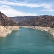
Lake Mead and Lake Powell
Water users have been able to counter previous dry spells by relying on the river’s main reservoirs. But after more than two decades of drought, both Lake Mead and Lake Powell are only about one-quarter full. The reservoirs’ rapid declines have forced the Bureau of Reclamation to order unprecedented water cuts to Arizona and Nevada. Mexico is taking similar cuts under binational agreements. And Reclamation has warned more severe actions are needed to prevent the collapse of the Colorado River system.
The Compact signatories, relying on data from a small but abnormally wet time period, estimated the river’s annual average natural flow in the Upper Basin to be about 18 million acre-feet. The figure, they asserted, was enough to cover 7.5 million acre-feet of water in perpetuity for the Upper Basin states of Colorado, New Mexico, Utah and Wyoming, and 7.5 million acre-feet for the Lower Basin states of Arizona, Nevada and California. They also agreed that any water committed to Mexico would be supplied equally by the two Basins. Native American tribes, who now legally hold substantial rights to the river’s water, were barely mentioned.
Climate Change and Water in the West
Brad Udall, Colorado State University climate researcher, said it’s becoming harder and harder for the river to meet the promises outlined in the Compact and the accompanying set of agreements, laws and court cases referred to as the Law of the River. He warned dozens of water managers and policy experts at a recent Water Education Foundation Symposium that climate change caused by greenhouse gas emissions is rapidly and permanently shifting precipitation trends in the Basin.
“It’s not a drought, it’s not temporary, it’s aridification,” said Udall. “Additional 1 degree Celsius or more warming by 2050, Lee Ferry flows in 9 million acre-feet are possible. Every important trend line [is] heading in the wrong direction, notably our reservoirs, but all the science trends as well.”
“Simple Math”
Data from recent decades shows it’s becoming uncommon for the river to meet the benchmark used to craft the Compact. Estimated annual flows at Lee Ferry, a key dividing point between the Colorado River’s Upper and Lower Basins, have surpassed 18 million acre-feet just four times since 1991, while the river’s average flow since 2000 has been 12.3 million acre-feet.
“If we’re taking out more than comes in, it is really simple math that the reservoirs are going to continue to decline,” said Rebecca Mitchell, director of the Colorado Water Conservation Board, the state’s water management agency.
Mitchell was among nearly 200 state and regional water managers, farmers, tribal leaders and other water interests from the seven Basin states, along with key federal and Mexican officials, who attended the Foundation’s biennial Colorado River Symposium in late September to mark the Compact’s 100th anniversary and to discuss the risks and challenges ahead for the iconic Southwestern river.
Collaboration and compromise
Discussions were sometimes sobering and sometimes tense, underscoring the growing risks to a river depended upon for drinking water by 40 million people and for irrigation of more than 4 million farmland acres across the Basin. An undercurrent of the discussions was whether Basin interests can avoid taking their differences to court – a prime motivation behind creating the 1922 Compact. Despite the occasional sharply worded airing of differences between Upper and Lower Basin interests, there was broad acknowledgement that action is needed to keep the river system functioning.
U.S. Bureau of Reclamation Commissioner Maria Camille Calimlim Touton was among those urging water interests throughout the Basin to continue working collaboratively toward solutions and she provided a broad outline of actions that federal officials are preparing to take in 2023 – including reducing water releases from Lake Powell and Lake Mead – to keep the river from crashing.
“The actions we choose to take over the next two years,” Touton told participants, “will define the fate of the Colorado River for the next century.”
(Editor’s Note: This article is provided courtesy of Western Water. Read full article here. The Colorado River Compact is in full focus during the Colorado River Water Users Association annual conference December 14-16 in Las Vegas).