Snowmelt Runoff Sets Streamflow Records in the Southwest
Across the western U.S., many areas received record or near-record amounts of snowpack over the winter. With the spring and summer temperatures melting the abundant snow, a record volume of streamflow has been recorded in several basins in the southwestern U.S., providing more water for the area later into the summer than is typically seen.
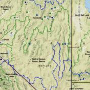
Snowmelt runoff in Walker and Carson basins
The Walker and Carson basins near the California-Nevada border, for example, have reported the largest volume of streamflow for April through July that has ever been observed in roughly a century, when the records began. The ample runoff is helping fill reservoirs that have been depleted from years of drought conditions.
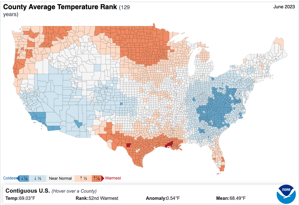
Weekly U.S. Drought Monitor: Cooler Northwest, Warmer Southwest
Dry conditions dominated the West and southern Plains, coupled with above-normal temperatures. Precipitation was most widespread throughout much of the upper Midwest and central Plains and into the Northeast. Almost the entire country had near- to above-normal temperatures this last week, with the greatest departures over the Southwest and central Plains where temperatures were at least 4-7 degrees above normal.
Cooler-than-normal temperatures were recorded in the Pacific Northwest with departures of 3-6 degrees below normal. At the end of the current U.S. Drought Monitor period, significant rains developed over portions of the Midwest and central Plains, and they will be accounted for in the next analysis.
July 2023 recorded more than 6,500 severe weather reports, the most preliminary July reports on record, according to our friends at the @NWSSPC. As we head into August, where is severe weather most likely this time of year? https://t.co/pySvHxoQQt pic.twitter.com/6C4u82SGYa
— NOAA Climate.gov (@NOAAClimate) August 7, 2023
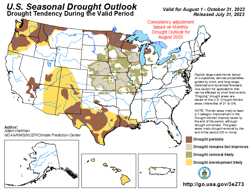
U.S. Seasonal Drought Outlook
Central portions of the Intermountain West may be spared degradation, as those areas are still showing residual benefits from above normal winter snowpack leading up to the summer, in addition to periods of above normal rainfall during the last 60 to 90 days. Seasonal temperature and precipitation outlooks, ENSO, and climatology favor widespread drought improvement and removal across the central U.S. However, drought persistence is favored across the Upper Midwest, although there is the potential for localized improvements.” Read full assessment: cpc.ncep.noaa.gov/products/expert_assessment/sdo_summary.php.
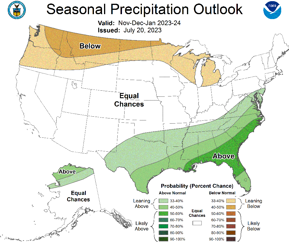
Seasonal Precipitation Outlook: November, December, January 2023-24
Colors show where total precipitation has an increased chance of being higher or lower than usual during the next three months. The darker the shading, the greater the chance for the indicated condition. White areas have equal chances for precipitation totals that are below, near, or above the long-term average (median) for the next three months.
Climate scientists base future climate outlooks on current patterns in the ocean and atmosphere. They examine projections from climate and weather models and consider recent trends. They also check historical records to see how much precipitation fell when patterns were similar in the past.
🌡️📈#ERA5 data from the #CopernicusClimate Change Service show that July 2023 was the hottest month on record globally.
Check the data 👉 https://t.co/Ug5FznAlMW pic.twitter.com/jnsJWOT53Z
— Copernicus ECMWF (@CopernicusECMWF) August 8, 2023
Copernicus Climate Change Service: July 2023 sees multiple global temperature records broken
- The global average temperature for July 2023 is confirmed to be the highest on record for any month.
- Antarctic sea ice extent continued to break records for the time of year, with a monthly value 15% below average, by far the lowest July extent since satellite observations began.
- July 2023 was wetter than average over most of northern Europe and in a region from the Black Sea and Ukraine to northwestern Russia. Drier than average conditions were experienced across the Mediterranean basin, with Italy and southeastern Europe having the largest anomalies.
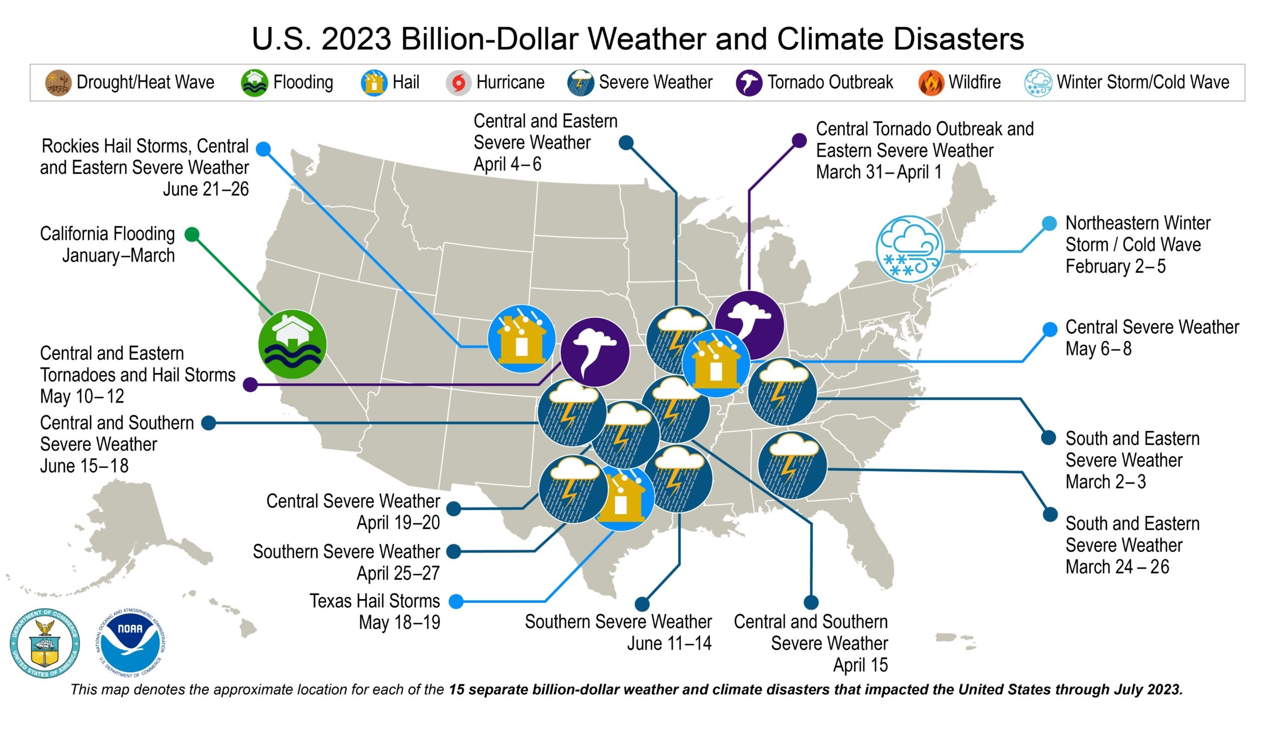
July 2023 NOAA State of Climate Report
Record-high temps & devastating floods struck the U.S. 15 separate billion-dollar disasters occurred during the 1st 7 months of 2023. More from NOAA’s July State of Climate report.
El Niño is anticipated to continue through the Northern Hemisphere winter (with a greater than 95% chance through December 2023-February 2024). An #ElNino Advisory remains in effect. https://t.co/5zlzaZ1aZx pic.twitter.com/j5Kb91Uoty
— NWS Climate Prediction Center (@NWSCPC) August 10, 2023
(Editor’s Note: Content for this story comes from the Natural Resources Conservation Service, which produces a weekly report using data and products from the National Water and Climate Center and other agencies. The report focuses on seasonal snowpack, precipitation, temperature, and drought conditions in the United States.)


 Sweetwater Authority Logo 2019